File:Kirgisen-Reich (840-924).PNG
跳至導覽
跳至搜尋
預覽大小:800 × 499 像素。 其他解析度:320 × 199 像素 | 640 × 399 像素 | 1,024 × 638 像素 | 1,253 × 781 像素。
原始檔案 (1,253 × 781 像素,檔案大小:1.42 MB,MIME 類型:image/png)
說明
說明
添加單行說明來描述出檔案所代表的內容
摘要
[編輯].PNG&action=edit§ion=1)
| 描述 |
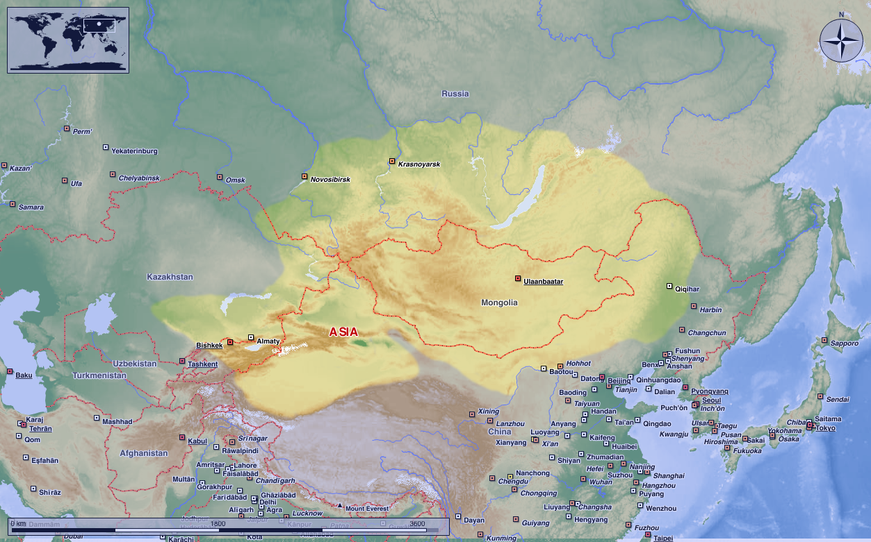
Deutsch: Das Kirgisen-Reich in seiner größten Ausdehung.
(Original text: Darstellungskarte zeigt das Kirgisen-Reich, das 840 das stammverwandte Reich der Uiguren zerschlug und dessen Erbe antrat.) 中文:叶尼塞吉尔吉斯的活动范围,吉尔吉斯人并没有在蒙古高原建立稳固的政权。
English: The map shows the Kyrgyz empire, which destroyed the related empire of the Uyghurs in 840 and inherited it. Kyrgyz Khaganate activity range, Kyrgyz people did not establish a stable political power in the Mongolian plateau.
|
| 日期 | 2004年八月17日 (原始上傳日期) |
| 來源 | Transferred from de.wikipedia to Commons. |
| 作者 | Postmann Michael |
| 授權許可 (重用此檔案) |
Public Domain |
授權條款
[編輯].PNG&action=edit§ion=2)
| 我,此作品的版權所有人,釋出此作品至公共領域。此授權條款在全世界均適用。 這可能在某些國家不合法,如果是的話: 我授予任何人有權利使用此作品於任何用途,除受法律約束外,不受任何限制。 |
原始上傳日誌
[編輯].PNG&action=edit§ion=3)
The original description page was here. All following user names refer to de.wikipedia.
- 2004-08-17 00:57 Postmann Michael 752×591× (37783 bytes) Das Kirgisen-Reich in seiner größten Ausdehung.
檔案歷史
點選日期/時間以檢視該時間的檔案版本。
| 日期/時間 | 縮圖 | 尺寸 | 用戶 | 備註 | |
|---|---|---|---|---|---|
| 目前 | 2023年8月21日 (一) 00:44 | | 1,253 × 781(1.42 MB) | HapHaxion(對話 | 貢獻) | Reverted to version as of 17:01, 15 April 2021 (UTC) |
| 2023年5月8日 (一) 23:18 |  | 1,048 × 614(757 KB) | JJUPLOADS22(對話 | 貢獻) | Reverted to version as of 20:27, 14 April 2021 (UTC) | |
| 2021年4月15日 (四) 17:01 |  | 1,253 × 781(1.42 MB) | MicBy67(對話 | 貢獻) | Reverted to version as of 14:30, 22 August 2020 (UTC). No improvement. | |
| 2021年4月14日 (三) 20:27 |  | 1,048 × 614(757 KB) | Бмхүн(對話 | 貢獻) | Adjust resolution | |
| 2020年8月22日 (六) 14:30 |  | 1,253 × 781(1.42 MB) | MicBy67(對話 | 貢獻) | Reverted to version as of 14:05, 22 August 2020 (UTC) | |
| 2020年8月22日 (六) 14:30 |  | 752 × 591(37 KB) | MicBy67(對話 | 貢獻) | Reverted to version as of 17:09, 10 May 2009 (UTC) | |
| 2020年8月22日 (六) 14:05 |  | 1,253 × 781(1.42 MB) | MicBy67(對話 | 貢獻) | Revision of the existing file. Topography, cities, etc. according to Marble (public domain) | |
| 2009年5月10日 (日) 17:09 |  | 752 × 591(37 KB) | Nachcommonsverschieber(對話 | 貢獻) | {{Information |Description={{de|Das Kirgisen-Reich in seiner größten Ausdehung. ----<br/> (Original text : ''Darstellungskarte zeigt das Kirgisen-Reich, das 840 das stammverwandte Reich der Uiguren zerschlug und dessen Erbe antrat.'') * erstellt am: 17. |
無法覆蓋此檔案。
檔案用途
下列3個頁面有用到此檔案:
全域檔案使用狀況
以下其他 wiki 使用了這個檔案:
- ar.wikipedia.org 的使用狀況
- az.wikipedia.org 的使用狀況
- bn.wikipedia.org 的使用狀況
- de.wikipedia.org 的使用狀況
- en.wikipedia.org 的使用狀況
- fa.wikipedia.org 的使用狀況
- fr.wikipedia.org 的使用狀況
- id.wikibooks.org 的使用狀況
- kk.wikipedia.org 的使用狀況
- pt.wikipedia.org 的使用狀況
- ru.wikipedia.org 的使用狀況
- ta.wikipedia.org 的使用狀況
- tr.wikipedia.org 的使用狀況
- uz.wikipedia.org 的使用狀況
- www.wikidata.org 的使用狀況
.PNG&oldid=794766475)