Category:History of Kyrgyzstan
Jump to navigation
Jump to search
aspect of history | |||||
| Upload media | |||||
| Pronunciation audio | |||||
|---|---|---|---|---|---|
| Instance of | |||||
| Facet of | |||||
| Location |
| ||||
| |||||
Subcategories
This category has the following 35 subcategories, out of 35 total.
A
B
D
- Kurmanjan Datka (19 F)
E
F
G
H
I
- Interhelpo (7 F)
K
- Kara-Kyrgyz Khanate (9 F)
- Kyrgyz History Society (1 F)
- Kyrgyz Khanate (13 F)
M
P
R
- Reichskommissariat Turkestan (2 F)
S
T
- Törökul Zanuzakov (5 F)
W
Y
Media in category "History of Kyrgyzstan"
The following 46 files are in this category, out of 46 total.
-
 Abdukadyr Urazbekov Signature.jpg 144 × 49; 23 KB
-
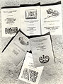 Amantur Akmataliev. Some books on Kyrgyz Ethnography.jpg 4,064 × 5,448; 6.56 MB
-
 Bayaly Isakeev Signature.png 1,500 × 500; 90 KB
-
 Berkutchi stone-cut sculpture MOISEIKIN.jpg 3,104 × 4,672; 883 KB
-
 Burgo Batyr.jpg 501 × 600; 129 KB
-
 C86ae9bf9d69e790910600aa8bced4fe XL.jpg 918 × 519; 142 KB
-
 Caravanserai Tash Rabat on Silk Road in Kyrgyzstan.jpg 2,000 × 3,008; 1.83 MB
-
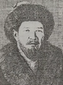 Cherikchi Biy.png 623 × 839; 776 KB
-
 Committee of the Latin Language of the Kyrgyz ASSR.jpg 3,058 × 2,000; 5.57 MB
-
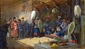 Cossacks in Kirgiz-Kaysats Orda by N.Karazin.jpg 1,000 × 573; 90 KB
-
-

-

-
 Interhelpo.jpg 197 × 202; 8 KB
-
 Interhelpotraktor.jpg 1,500 × 867; 323 KB
-
 Jaiyl Biy.png 1,378 × 1,378; 1 MB
-
 Jantay Batyr.jpg 2,022 × 2,702; 928 KB
-
 Kara Kyrgyz Khanate (West Burut) 1847 ad (cropped).jpg 1,080 × 804; 263 KB
-
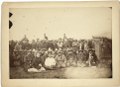
 Kirghiz (i.e. Kazakh) tribesmen with a local Russian Governor and his wife LCCN99615494.jpg 5,120 × 3,709; 2.07 MB
-
 Kirghiz (i.e. Kazakh) tribesmen with a local Russian Governor and his wife LCCN99615494.tif 5,120 × 3,709; 54.34 MB
-
 Kirghiz (i.e., Kazakh) aul or tents near Omsk LCCN99615492.jpg 1,024 × 776; 144 KB
-
 Kirghiz (i.e., Kazakh) aul or tents near Omsk LCCN99615492.tif 5,120 × 3,878; 56.81 MB
-
 Kirgisen-Reich (840-924).PNG 1,253 × 781; 1.42 MB
-
 Kyrgyz 1813.JPG 826 × 1,169; 121 KB
-
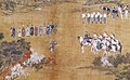 Kyrgyz ambassadors and Qianlong (cropped).jpg 348 × 214; 30 KB
-
 Kyrgyz Confederation map.jpg 1,100 × 768; 158 KB
-
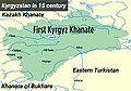 Kyrgyz Khanate XV Century map.jpg 1,100 × 768; 119 KB
-
 Kyrgyz religious rite 1562 ad (cropped).jpg 1,080 × 563; 164 KB
-
 Mamatkul Byi.jpg 845 × 1,180; 223 KB
-
 Map of Kyrgyz Confederation XVII century.jpg 1,100 × 768; 146 KB
-
 Map of Second Turkic Khaganate.png 1,644 × 959; 33 KB
-
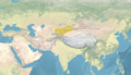 Map of the Kyrgyz Khanate 1500.png 3,196 × 1,840; 14.33 MB
-
 Map of the Kyrgyz Khanate 1512.png 3,196 × 1,840; 14.34 MB
-
 Map of the Kyrgyz Khanate 1600.png 3,196 × 1,840; 14.34 MB
-
 Map of the Kyrgyz Khanate in 1758.png 3,196 × 1,840; 14.34 MB
-
 PG - Semireche Cossack.jpg 1,024 × 941; 287 KB
-

-
 Seal Atake Biy.png 1,378 × 1,378; 325 KB
-
 Seal of Atake Biy cropped.jpg 240 × 272; 35 KB
-
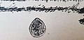 Seal of Atake Biy.jpg 1,070 × 520; 43 KB
-
 Shakemap, 2008 Kyrgyzstan earthquake.jpg 612 × 720; 143 KB
-
 State of Kirges 1562 ad (cropped).jpg 1,080 × 1,206; 188 KB
-
 Stone of Tagai Biy.jpg 2,000 × 1,333; 485 KB
-
 The Aksakal in front of his Yoort.jpg 466 × 731; 45 KB
-
 YuezhiIdeograms.jpg 448 × 720; 17 KB
-
 Балбай баатырдын катты жана мөөрү.jpg 985 × 2,025; 130 KB


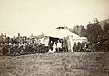
_men_posing_with_a_local_Russian_Governor,_his_wife,_and_their_child_in_front_of_a_yurt_LCCN99615493_(cropped).jpg)
_men_posing_with_a_local_Russian_Governor,_his_wife,_and_their_child_in_front_of_a_yurt_LCCN99615493.jpg)


_1847_ad_(cropped).jpg)
_tribesmen_with_a_local_Russian_Governor_and_his_wife_LCCN99615494.jpg)
_aul_or_tents_near_Omsk_LCCN99615492.jpg)
.PNG)

.jpg)


.jpg)


_(14782413134).jpg)


.jpg)


