File:Kisatchie National Forest, Caney Ranger District, Louisiana LOC 2011590590.jpg
Jump to navigation
Jump to search

Size of this preview: 800 × 583 pixels. Other resolutions: 320 × 233 pixels | 640 × 467 pixels | 1,024 × 747 pixels | 1,280 × 933 pixels | 2,560 × 1,866 pixels | 6,702 × 4,886 pixels.
Original file (6,702 × 4,886 pixels, file size: 4.15 MB, MIME type: image/jpeg)
Captions
Captions
Add a one-line explanation of what this file represents
Summary
[edit]| Description |
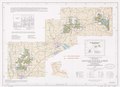
English: Title from panel. "Louisiana Meridian." Includes text, index to topographic map, key map, and list to recreation sites. Available also through the Library of Congress Web site as a raster image. |
||
| Title | Kisatchie National Forest, Caney Ranger District, Louisiana | ||
| Shelf ID | G4012.K5 1988 .U52 | ||
| Date | |||
| Source | https://www.loc.gov/item/2011590590/ | ||
| Author | United States. Forest Service | ||
| Permission (Reusing this file) |
|
||
| Other versions |
|
||
| Location | United States · Lousiana · Louisiana · Kisatchie National Forest. · Kisatchie National Forest | ||
| Part of | American Memory · General Maps · Catalog · Geography And Map Division | ||
| Subject | United States · Maps · Kisatchie National Forest (La.) · Louisiana · Kisatchie National Forest |

Licensing
[edit]
| This work is from the Library of Congress. According to the library, there are no known copyright restrictions on the use of this work. |  |
File history
Click on a date/time to view the file as it appeared at that time.
| Date/Time | Thumbnail | Dimensions | User | Comment | |
|---|---|---|---|---|---|
| current | 02:24, 31 July 2019 | | 6,702 × 4,886 (4.15 MB) | Fæ (talk | contribs) | LOC Maps https://www.loc.gov/item/2011590590/ #102 |
You cannot overwrite this file.
File usage on Commons
The following page uses this file: