File:Kouri Island gsi-20180219.jpg
Jump to navigation
Jump to search

Size of this preview: 600 × 600 pixels. Other resolutions: 240 × 240 pixels | 480 × 480 pixels | 768 × 768 pixels | 1,024 × 1,024 pixels | 2,048 × 2,048 pixels | 5,000 × 5,000 pixels.
Original file (5,000 × 5,000 pixels, file size: 6.67 MB, MIME type: image/jpeg)
Captions
Captions
Add a one-line explanation of what this file represents
Summary[edit]
| Description |
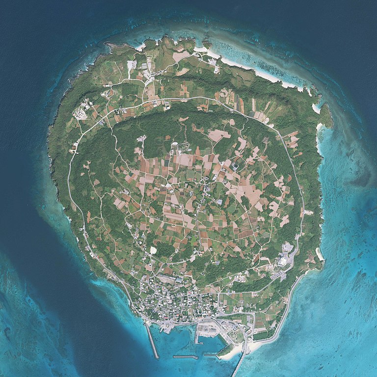
English: Kouri Island, Nakijin, Okinawa Prefecture, Japan. Combined 10 aerial photos taken by Geospatial Information Authority of Japan.
日本語: 古宇利島
国土交通省の地図・空中写真閲覧サービスを元に作成。10枚の航空写真を使用。
|
| Date | Taken on 19 February 2018 |
| Source | COK20172-C1-2, C1-3, C1-4, C1-5, C1-6, C2-3, C2-4, C2-5, C2-6, C2-7 |
| Author |
English: Geospatial Information Authority of Japan
日本語: 国土地理院 |
| Camera location | | View this and other nearby images on: OpenStreetMap |
|---|
| This is a retouched picture, which means that it has been digitally altered from its original version. Modifications: Combined 10 aerial photos and cropped. Modifications made by Kugel~commonswiki.
|

|
NOTE: This image is a panorama consisting of 10 frames that were merged or stitched in software. As a result, this image necessarily underwent some form of digital manipulation. These manipulations may include blending, blurring, cloning, and colour and perspective adjustments. As a result of these adjustments, the image content may be slightly different from reality at the points where multiple images were combined. This manipulation is often required due to lens, perspective, and parallax distortions.
|
Licensing[edit]

|
The copyright holder of this file, Ministry of Land, Infrastructure, Transport and Tourism, allows anyone to use it for any purpose, provided that the copyright holder is properly attributed. Redistribution, derivative work, commercial use, and all other use is permitted. |
Attribution:
National Land Image Information (Color Aerial Photographs), created by Ministry of Land, Infrastructure, Transport and Tourism, distributed by Geospatial Information Authority of Japan
|

File history
Click on a date/time to view the file as it appeared at that time.
| Date/Time | Thumbnail | Dimensions | User | Comment | |
|---|---|---|---|---|---|
| current | 06:16, 19 June 2018 | | 5,000 × 5,000 (6.67 MB) | Kugel~commonswiki (talk | contribs) | {{Information |Description={{en|1=Kouri Island, Nakijin, Okinawa Prefecture, Japan. Combined 10 aerial photos taken by Geospatial Information Authority of Japan. *Reference Number : COK20172 *Location : Nago *Course and Photo Number : C1-2~6, C2-3~7 *Date taken : 19 February 2018 }} {{ja|1=古宇利島 国土交通省の地図・空中写真閲覧サービスを元に作成。10枚の航空写真を使用。 * 整理番号 : COK20172 * 撮影地域 : 名護 * コース - 写真番号 : C1-2からC1-6, C2-3からC2-7 * 撮影年月日 : 2018年2月19日 }} |Source=[http://mapps.gsi.go.jp/contentsImageDisplay.do?specificationId... |
You cannot overwrite this file.
File usage on Commons
The following 3 pages use this file:
File usage on other wikis
The following other wikis use this file:
- Usage on ceb.wikipedia.org
- Usage on ja.wikipedia.org
- Usage on www.wikidata.org
- Usage on zh.wikipedia.org