File:Kukenan Roraima GS.jpg

元のファイル (4,851 × 1,533 ピクセル、ファイルサイズ: 3.64メガバイト、MIME タイプ: image/jpeg)
キャプション
キャプション
概要[編集]
| 解説 |
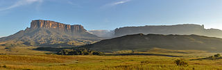
English: Morning view of Kukenan and Roraima tepuis, from Tëk river camp (river visible in the image), in Gran Sabana, Venezuela. Roraima tepui is actually some 100 mts higher than Kukenan, but due to the perspective of the picture, it looks like it is lower.
Español: Vista matutina de los tepuys Kukenan y Roraima, desde el campamente del río Tëk (con el río visible en la imagen), en la Gran Sabana, Venezuela. El tepuy Roraima es en realidad unos cien metros más alto que el Kukenan, aunque por la perspectiva de la foto, parece lo contrario.
Français : Vue matinale sur le Tepuy Kukenan et le Mont Roraima, depuis le camp de la rivière Tëk, dans la Gran Sabana (Vénézuela). Le Roraima Fait 100 m de plus que le Kukenan, bien qu'il apparaisse moins haut sur l'image, à cause de la perspective.
Bosanski: Jutarnja panorama Kukenana i tepui planine Roraima, iz riječnog kampa Tëk, Gran Sabana, Venecuela.
Italiano: Panorama al mattino dei tepui di Kukenan e Roraima dal campo sul fiume Tëk, Gran Sabana in Venezuela.
|
|||
| 日付 | ||||
| 原典 | 投稿者自身による著作物 | |||
| 作者 | Paolo Costa Baldi | |||
| 許可 (ファイルの再利用) |
|
| カメラの位置 | | 以下のサービスでこの位置を確認する: オープンストリートマップ |
|---|
|
この画像は2015年7月10日の今日の一枚に選ばれました。その際の説明文は以下のとおりでした。 他の言語
Bosanski: Jutarnja panorama Kukenana i tepui planine Roraima, iz riječnog kampa Tëk, Gran Sabana, Venecuela. Español: Vista matutina de los tepuys Kukenan y Roraima, desde el campamente del río Tëk (con el río visible en la imagen), en la Gran Sabana, Venezuela. Italiano: Panorama al mattino dei tepui di Kukenan e Roraima dal campo sul fiume Tëk, Gran Sabana in Venezuela. |
ライセンス[編集]
- あなたは以下の条件に従う場合に限り、自由に
- 共有 – 本作品を複製、頒布、展示、実演できます。
- 再構成 – 二次的著作物を作成できます。
- あなたの従うべき条件は以下の通りです。
- 表示 – あなたは適切なクレジットを表示し、ライセンスへのリンクを提供し、変更があったらその旨を示さなければなりません。これらは合理的であればどのような方法で行っても構いませんが、許諾者があなたやあなたの利用行為を支持していると示唆するような方法は除きます。
- 継承 – もしあなたがこの作品をリミックスしたり、改変したり、加工した場合には、あなたはあなたの貢献部分を元の作品とこれと同一または互換性があるライセンスの下に頒布しなければなりません。

|
この文書は、フリーソフトウェア財団発行のGNUフリー文書利用許諾書 (GNU Free Documentation License) 1.2またはそれ以降のバージョンの規約に基づき、複製や再配布、改変が許可されます。不可変更部分、表紙、背表紙はありません。このライセンスの複製は、GNUフリー文書利用許諾書という章に含まれています。 |
| 注釈 | この画像には注釈がついています: コモンズで注釈を見る |
ファイルの履歴
過去の版のファイルを表示するには、その版の日時をクリックしてください。
| 日付と時刻 | サムネイル | 寸法 | 利用者 | コメント | |
|---|---|---|---|---|---|
| 現在の版 | 2011年10月20日 (木) 03:42 | 4,851 × 1,533 (3.64メガバイト) | Paolostefano1412 (トーク | 投稿記録) | {{Information |Description ={{en|1=Morning view of Kukenan and Roraima tepuis, from River Tëk camp (river visible in the image).}} {{es|1=Vista matutina de los tepuys Kukenan y Roraima, desde el campamente del río Tëk (con el río visible en la imag |
このファイルは上書きできません。
ファイルの使用状況
以下の 39 ページがこのファイルを使用しています:
- Venezuela
- User:Biyergeyiyer
- User:Paolostefano1412
- User:Rodrigo.Argenton/test
- User:Stratokumulus/Favorites
- User:Tomer T
- User:Ö/Best/2012
- User talk:Tomer T/Archive 1
- Commons:Featured picture candidates/File:Kukenan Roraima GS.jpg
- Commons:Featured picture candidates/Log/January 2012
- Commons:Featured pictures/Places/Natural
- Commons:Featured pictures/Places/Panoramas
- Commons:Featured pictures/chronological/2012-A
- Commons:Photo challenge/2015 - May - Panoramas
- Commons:Picture of the Year/2012/Galleries/2012-A
- Commons:Picture of the Year/2012/Galleries/ALL
- Commons:Picture of the Year/2012/Galleries/Index/1
- Commons:Picture of the Year/2012/Galleries/JAN
- Commons:Picture of the Year/2012/Galleries/Panoramic views
- Commons:Picture of the Year/2012/R1/Kukenan Roraima GS.jpg
- Commons:Picture of the Year/2012/Results/R1/ALL
- Commons:Picture of the Year/2012/Results/R1/ALL/gallery
- Commons:Picture of the Year/2012/Results/R1/ALL/thumbnailtable
- Commons:Picture of the Year/2012/Results/R1/Panoramic views
- Commons:Wiki Loves Earth 2024 in Brazil
- Commons talk:Photo challenge/themes/Archive
- Template:Potd/2015-07
- Template:Potd/2015-07-10
- Template:Potd/2015-07-10 (bs)
- Template:Potd/2015-07-10 (cs)
- Template:Potd/2015-07-10 (en)
- Template:Potd/2015-07-10 (es)
- Template:Potd/2015-07-10 (hu)
- Template:Potd/2015-07-10 (it)
- Template:Potd/2015-07-10 (ko)
- Template:Potd/2015-07-10 (nl)
- Template:Potd/2015-07-10 (pt)
- Template:Potd/2015-07-10 (uk)
- Category:La Gran Sabana
グローバルなファイル使用状況
以下に挙げる他のウィキがこの画像を使っています:
- ast.wikipedia.org での使用状況
- av.wikipedia.org での使用状況
- az.wikipedia.org での使用状況
- be-tarask.wikipedia.org での使用状況
- bn.wikipedia.org での使用状況
- bs.wikipedia.org での使用状況
- crh.wikipedia.org での使用状況
- cs.wikipedia.org での使用状況
- cv.wikipedia.org での使用状況
- cy.wikipedia.org での使用状況
- da.wikipedia.org での使用状況
- de.wikipedia.org での使用状況
- en.wikipedia.org での使用状況
- Wikipedia:WikiProject Protected areas
- Gran Sabana
- Portal:Venezuela
- Wikipedia:Featured pictures/Places/Panorama
- Talk:Gran Sabana
- User talk:Paolostefano1412
- Wikipedia:WikiProject Geology/Recognized content
- Wikipedia:Featured pictures thumbs/33
- Wikipedia:Featured picture candidates/January-2013
- User talk:Razr Nation/2013/2
- Wikipedia:Featured picture candidates/Kukenan Roraima GS
- User:Razr Nation/FPs
- Distribution of Heliamphora
- Eastern Tepuis
- Wikipedia:Picture of the day/May 2014
- User talk:Razr Nation/2014/4
- Template:POTD/2014-05-29
- Wikipedia:Main Page history/2014 May 29
- Wikipedia:WikiProject Geology/Automated list of recognized content
- Raleigh's El Dorado expedition
- Portal:Venezuela/Recognized content
- en.wikivoyage.org での使用状況
- es.wikipedia.org での使用状況
- La Gran Sabana
- Anexo:Patrimonio de la Humanidad en América Latina y el Caribe
- Wikipedia:Imágenes destacadas/Lugares/Sudamérica
- Wikipedia:Recurso del día/501 - 600
- Wikipedia:Candidatos a recursos destacados/Diciembre-2011
- Wikipedia:Candidatos a recursos destacados/Kukenan Roraima GS.jpg
- Plantilla:RDD/556
- Wikipedia:Recurso del día/enero de 2012
- Wikipedia:Recurso del día/febrero de 2013
- Usuario discusión:Eduardosalg/Archivo57/Archivo56/Archivo39
- Usuario:JosueCarrion
- Usuario:Eduardosalg/Vitrina
- Usuario:Leanex77
このファイルのグローバル使用状況を表示する。