File:Kungsgårdarna i Norrland under medeltiden.tif
Jump to navigation
Jump to search

Size of this PNG preview of this TIF file: 405 × 600 pixels. Other resolutions: 162 × 240 pixels | 324 × 480 pixels | 518 × 768 pixels | 691 × 1,024 pixels | 1,382 × 2,048 pixels | 2,857 × 4,232 pixels.
Original file (2,857 × 4,232 pixels, file size: 1.15 MB, MIME type: image/tiff)
Captions
Captions
Add a one-line explanation of what this file represents
Summary
[edit]| Description |
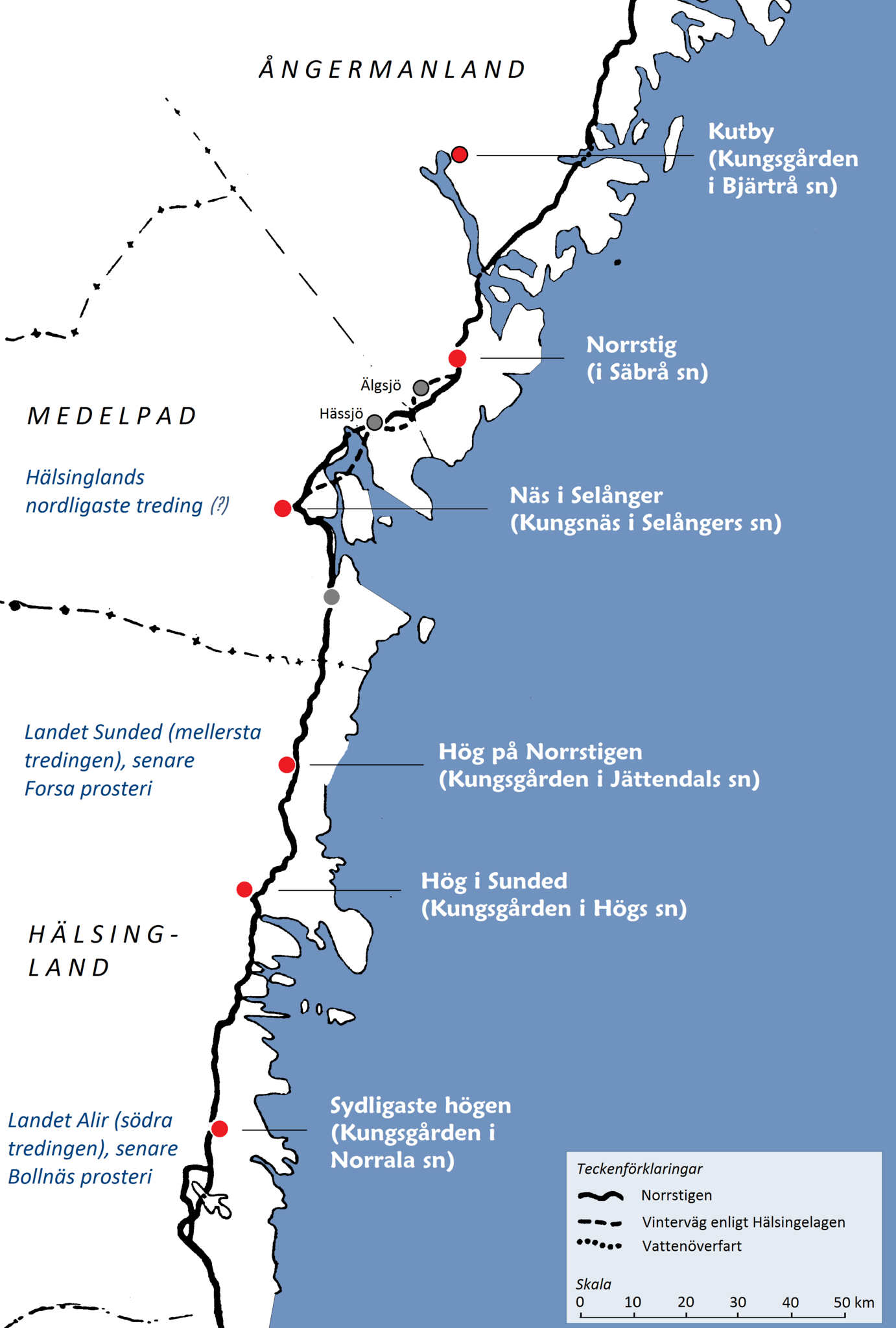
English: Map of the coastline of Norrland in Sweden displaying the location of the royal farmsteads, centers for tax collection and judicial hearings during the Middle Ages. Norrland ("Northland ") is the northernmost, least populated and by far the largest of the three traditional lands of Sweden.
Svenska: Karta som utvisar placeringen av de medeltida kungsgårdarna längs Norrlandskusten.) |
| Date | |
| Source |
Svenska: Kartan är en bearbetning av en karta som ursprungligen presenterades i Nils Fribergs Vägarna i Västernorrlands län. Typiska drag i deras naturgeografiska struktur och äldre utveckling jämte utblickar över det svenska vägväsendet i övrigt, speciellt Norrland. Första delen. Meddelande från geografiska institutet vid Stockholms högskola Nr 80 A. Stockholm och Härnösand 1951. |
| Author | Urban Sikeborg, Sollentuna |
Licensing
[edit]| I, the copyright holder of this work, release this work into the public domain. This applies worldwide. In some countries this may not be legally possible; if so: I grant anyone the right to use this work for any purpose, without any conditions, unless such conditions are required by law. |
File history
Click on a date/time to view the file as it appeared at that time.
| Date/Time | Thumbnail | Dimensions | User | Comment | |
|---|---|---|---|---|---|
| current | 08:19, 1 December 2011 |  | 2,857 × 4,232 (1.15 MB) | Minor~commonswiki (talk | contribs) | Texten med namnen på kungsgårdarna har förstorats. Ett frågetecken har lagts till för texten »Hälsinglands nordligaste treding» för att markera att uppgiften bygger på ett indicieresonemang. |
| 22:36, 1 September 2011 |  | 2,857 × 4,232 (1.12 MB) | Minor~commonswiki (talk | contribs) | Enlarged captions for better readability. Added specification of the three parts (»tredingar») of the Hälsingland province mentioned in the Hälsinge Law from the beginning of the 14th century. | |
| 03:01, 1 September 2011 |  | 2,857 × 4,232 (1,019 KB) | Minor~commonswiki (talk | contribs) | {{Information |Description=Karta som utvisar placeringen av de medeltida kungsgårdarna längs Norrlandskusten. (Map displaying the location of the royal farmsteads – centers for tax collection and judicial hearings – were located by the coastline in |
You cannot overwrite this file.
File usage on Commons
There are no pages that use this file.
File usage on other wikis
The following other wikis use this file:
- Usage on da.wikipedia.org
- Usage on nn.wikipedia.org
- Usage on no.wikipedia.org
- Usage on sv.wikipedia.org