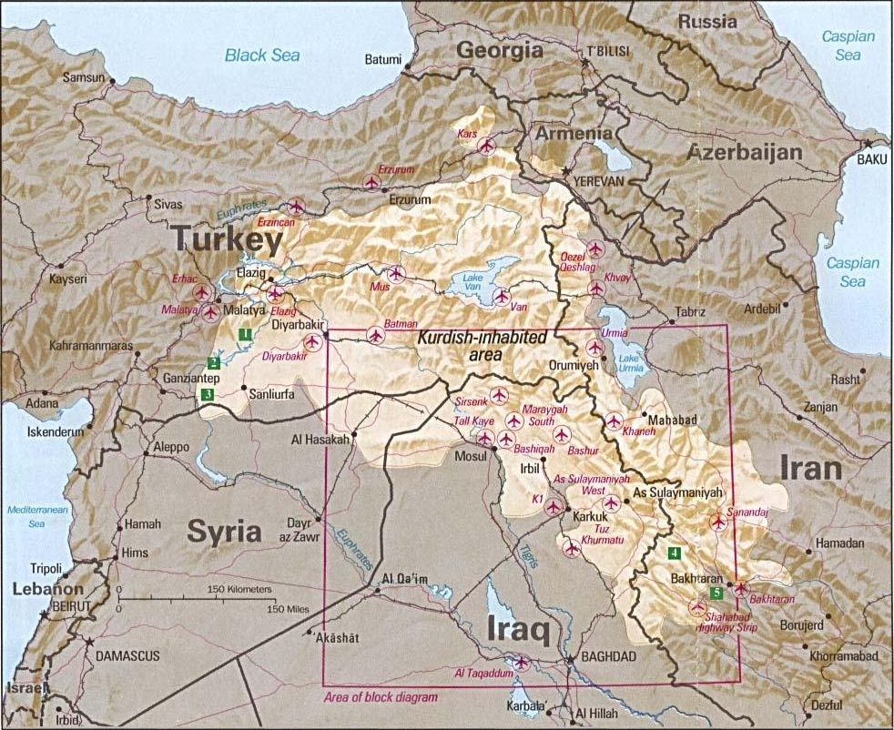
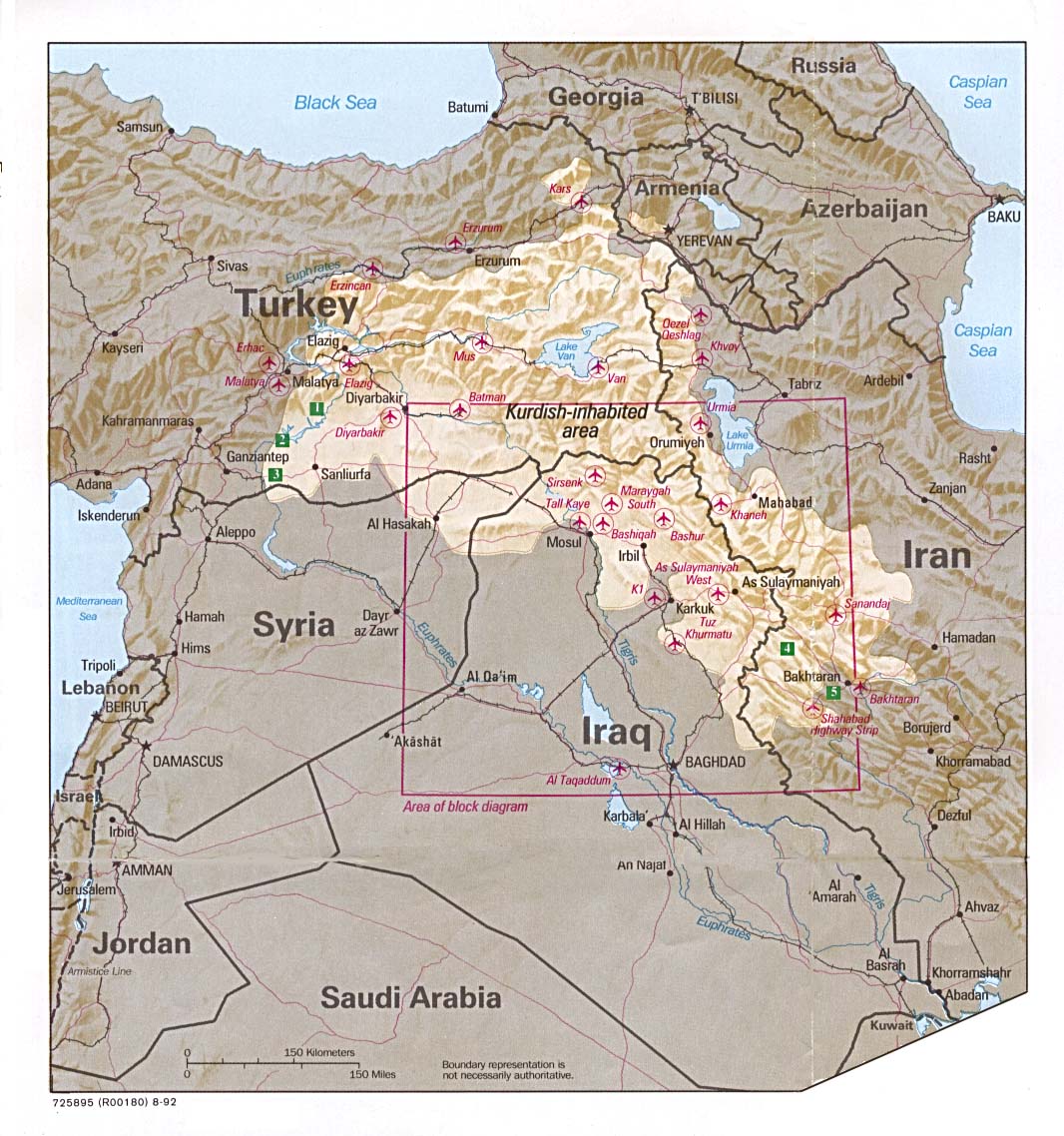
File:Kurdish-inhabited area by CIA (1992).jpg
跳至導覽
跳至搜尋
預覽大小:734 × 599 像素。 其他解析度:294 × 240 像素 | 588 × 480 像素 | 982 × 802 像素。
原始檔案 (982 × 802 像素,檔案大小:630 KB,MIME 類型:image/jpeg)
說明
說明
添加單行說明來描述出檔案所代表的內容
摘要[編輯]
| 描述 |
Ελληνικά: Περιοχές κατοικούμενες από Κούρδους κατά τη CIA (1992) |
| 日期 | August 1992 or earlier |
| 來源 |
Perry-Castañeda Library Map Collection at The University of Texas at Austin [1] linked from Perry-Castañeda Library Map Collection at The University of Texas at Austin |
| 作者 |
English: Source stated "The following maps were produced by the U.S. Central Intelligence Agency, unless otherwise indicated." The original, non-cropped map also states: "Boundary representation is not necessarily authoritative". |
| 其他版本 |

.jpg&action=edit§ion=1)
請不要覆蓋此文件:任何裁剪或其他修復工作應以新文件名上傳,並在此頁使用“other versions=”參數標註,故該文件能夠保持其所鏈接的CIA原樣。此頁面上的元數據直接導入自CIA檔案記錄;維基用戶可以添加輔助描述文本至“description=”參數下,但請不要修改其他內容。
(注意: 建議放置此模板的編輯解釋該文件如何使用此要求。)
授權條款[編輯]
.jpg&action=edit§ion=2)
| 本圖像是中央情報局僱員的職務作品。作為美國聯邦政府的作品,本圖像或媒體屬於公有領域。
|

|
See also[編輯]
.jpg&action=edit§ion=3)
- File:Kurdish lands 92.jpg - cropped and down-scaled version of same map apparently first uploaded at English wikipedia in 12 May 2003 from [2] and transferred to Commons on 2007-09-08
- Image:Kurdish lands 92 cropped.jpg - apparently cropped on 15 Jun 2003 (see w:en:Talk:Kurdish people/Archive 1) moved to Commons on or before 2006-12-16 but deleted on 9 February 2007 with comment: Superceeded ny Image:Kurdish-inhabited area by CIA (1992).jpg
檔案歷史
點選日期/時間以檢視該時間的檔案版本。
.jpg&uselang=zh-tw&dir=prev)
.jpg&uselang=zh-tw&offset=20100807100521)
.jpg&uselang=zh-tw&offset=&limit=20)
.jpg&uselang=zh-tw&offset=&limit=50)
.jpg&uselang=zh-tw&offset=&limit=100)
.jpg&uselang=zh-tw&offset=&limit=250)
.jpg&uselang=zh-tw&offset=&limit=500)
| 日期/時間 | 縮圖 | 尺寸 | 使用者 | 備註 | |
|---|---|---|---|---|---|
| 目前 | 2010年8月20日 (五) 07:47 | | 982 × 802(630 KB) | Sv1xv(留言 | 貢獻) | Reverted to version as of 18:21, 9 February 2007 |
| 2010年8月19日 (四) 20:47 |  | 975 × 795(177 KB) | Saadwand(留言 | 貢獻) | Reverted to version as of 10:05, 7 August 2010 | |
| 2010年8月18日 (三) 05:15 |  | 975 × 795(556 KB) | Kintetsubuffalo(留言 | 貢獻) | make a new map, stop warring, per discussion | |
| 2010年8月17日 (二) 20:51 |  | 975 × 795(177 KB) | Daryai(留言 | 貢獻) | Reverted to version as of 12:55, 14 August 2010 | |
| 2010年8月14日 (六) 15:13 |  | 975 × 795(556 KB) | Kintetsubuffalo(留言 | 貢獻) | we're not going to edit war on this-create your own map | |
| 2010年8月14日 (六) 12:55 |  | 975 × 795(177 KB) | Abuadab(留言 | 貢獻) | Reverted to version as of 10:05, 7 August 2010 | |
| 2010年8月13日 (五) 21:48 |  | 975 × 795(556 KB) | Prosfilaes(留言 | 貢獻) | It's a CIA map as of 1992; if you want to update it, feel free to copy it | |
| 2010年8月13日 (五) 20:45 |  | 975 × 795(177 KB) | Leosan(留言 | 貢獻) | Reverted to version as of 10:05, 7 August 2010 | |
| 2010年8月7日 (六) 18:14 |  | 975 × 795(556 KB) | Kintetsubuffalo(留言 | 貢獻) | changes fundaments of CIA map for that date. if you want to update, make a new map with a different date | |
| 2010年8月7日 (六) 10:05 |  | 975 × 795(177 KB) | Saadwand(留言 | 貢獻) | River coloured. |
無法覆蓋此檔案。
檔案用途
下列6個頁面有用到此檔案:
全域檔案使用狀況
以下其他 wiki 使用了這個檔案:
- an.wikipedia.org 的使用狀況
- ar.wikipedia.org 的使用狀況
- ar.wikiversity.org 的使用狀況
- ast.wikipedia.org 的使用狀況
- azb.wikipedia.org 的使用狀況
- be.wikipedia.org 的使用狀況
- bn.wikipedia.org 的使用狀況
- br.wikipedia.org 的使用狀況
- ca.wikipedia.org 的使用狀況
- ca.wikinews.org 的使用狀況
- ce.wikipedia.org 的使用狀況
- ckb.wikipedia.org 的使用狀況
- cs.wikipedia.org 的使用狀況
- da.wikipedia.org 的使用狀況
- de.wikipedia.org 的使用狀況
- Irak
- Kurden
- Portal:Kurdistan
- Portal:Kurdistan/Willkommen
- Wikipedia:WikiProjekt Kurdistan
- Wikipedia:WikiProjekt Kurdistan/Intro
- Wikipedia:WikiProjekt Kurdistan/Benutzer
- Wikipedia:WikiProjekt Kurdistan/Teilnehmer
- Benutzer:Bohater/ Kurdisch
- Wikipedia:WikiProjekt Kurdistan/Benutzer Box
- Benutzer:Bohater/Spielwiese
- Wikipedia:WikiProjekt Kurdistan/logo
- Benutzer:Projekt-Till/In Memoriam
- Benutzer:Yoda41
- Diskussion:Völkermord an den irakischen Turkmenen
- dsb.wikipedia.org 的使用狀況
- el.wikipedia.org 的使用狀況
- en.wikipedia.org 的使用狀況
檢視此檔案的更多全域使用狀況。
.jpg)
.jpg&oldid=711200792)