File:L'Amerique divisée Par Grands Etats Par le Sr Janvier Géographe A Paris (MAPS 31).jpg

Original file (7,254 × 4,980 pixels, file size: 6.95 MB, MIME type: image/jpeg)
Captions
Captions
|
|
|
This image was automatically transferred from the collections of the University of Washington. While certainly the majority of metadata in their database is correct, it is not necessarily written by individuals who are expert on the material they are describing. Such images often have incorrect dates, locations, or other information. If you can verify that this information is correct, or correct it if it isn't, please do so and remove this template. Also, if you are correcting information, please also let the library know so that they can update the metadata on their site. You can contact UW LIBRARIES MSCUA at photos |
Summary
[edit]| Title |
English: America Divided into Great States by Mr. Janvier, Geographer at Paris
Français : L'Amerique divisée Par Grands Etats Par le Sr. Janvier Géographe A Paris |
|||||||||||||||||||||||
| Description |
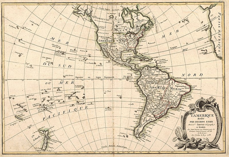
English: Copper engraving handcolored with watercolor. Outline color. Relief shown pictorially. Contains illegible watermark. Printed in cartouche in lower right corner: “L’Amerique divisée Par Grands Etats Par le Sr. Janvier Géographe A Paris chez Lattré Graveur rue St. Jacques, prés la Fontaine Saint Severin, a la Ville de Bordeaux. Avec Privilege du Roy. 1783.” Printed beneath cartouche: “[Illegible].” Printed above top right corner outside border: ”No. 31.” Written in pencil on verso along top edge: "no. 42. 55." Includes areas of exploration along the northwest coast of North America marked by name of explorer including: Captain Bering, Tszirikow in 1741, Admiral de Fonte, Juan de Fuca and Martin D’Aguilar. Also shows New Zealand and many islands in the South Pacific Ocean. Hawaii or “Owhy hee” is shown in the Sandwich Islands as the place where Captain Cook died. The eastern region of North America belonging to the United States is shown with its western border as the Mississippi River. Faintly visible in the northwest region of North America are the signs of an earlier imprint showing a Sea of the West and possibly a Northwest Passage. Includes Illustrations of fruits and branches around cartouche. Prime meridian: Teneriff. Scale: c.a. 1:55,000,000. [E 180 degrees—E 360 degrees / N 80 degrees—S 70 degrees].Jean Janvier also known as "Sieur Jean Janvier" and "Robert Janvier" was a French geographer in Paris. He worked on many maps himself but frequently collaborated with others. Many of his maps appear in atlases by others. His works include: "France" with Longchamps (1751), "Isles Brit." With Bordeaux (1759), a map in "Atlas de Géographie ancienne et modern" by Jean de Beaurain, "America" with Longchamps (1754), maps of the world, the continents, France and Germany (c.a. 1760), "L'Amérique" (1772) and "Paris" with Lattré (1783-90) (Moreland and Bannister, 136; Tooley, 334). Jean Lattré was an engraver and publisher in France. He engraved for Vaugondy (1743), Janvier (1760) and Bonne. His works include: "Malte" (1752), "Chambry" (1754), "Bordeaux" (1759), "Dijon" (1762), "Paris" (1765), "Atlas Moderne" (1771, 1783, 1793) and "Etats Unis (1784) (Tooley, 379). Source(s): "Rare Maps Held in Research Collections Master List (In Accession Number Order)." McMaster University Library. 2008. Moreland, Carl and David Bannister. "Antique Maps: A Collector's Handbook." New York: Longman Group, Ltd., 1983. Tooley, Ronald Vere. "Tooley's Dictionary of Mapmakers." Hertfordshire: Map Collector Publications Limited, 1979.
|
|||||||||||||||||||||||
| Publisher | Lattré, Jean | |||||||||||||||||||||||
| Digital ID Number | MAP097 | |||||||||||||||||||||||
| Condition | Small brown stains along bottom of centerfold. Small piece missing from lower right corner of leaf. Has binder's guard. | |||||||||||||||||||||||
| Date | ||||||||||||||||||||||||
| Source |
English: World and Regional Maps Collection |
|||||||||||||||||||||||
| Creator |
English: Janvier, Jean Denis fl. English: Jean Lattré |
|||||||||||||||||||||||
| Permission (Reusing this file) |
|
|||||||||||||||||||||||
| Geotemporal data | ||||||||||||||||||||||||
| Map location | Western Hemisphere | |||||||||||||||||||||||
| Georeferencing | If inappropriate please set warp_status = skip to hide. | |||||||||||||||||||||||
| Place of publication | Paris | |||||||||||||||||||||||
| Archival data | ||||||||||||||||||||||||
| Collection |
|
|||||||||||||||||||||||
| Accession number | ||||||||||||||||||||||||
| Dimensions | height: 31 cm (12.2 in); width: 45 cm (17.7 in) | |||||||||||||||||||||||

.jpg&action=edit§ion=1)
| Annotations | This image is annotated: View the annotations at Commons |
.jpg)
File history
Click on a date/time to view the file as it appeared at that time.
| Date/Time | Thumbnail | Dimensions | User | Comment | |
|---|---|---|---|---|---|
| current | 05:33, 8 July 2022 | | 7,254 × 4,980 (6.95 MB) | BMacZeroBot (talk | contribs) | Batch upload (Commons:Batch uploading/University of Washington Digital Collections) |
You cannot overwrite this file.
File usage on Commons
There are no pages that use this file.
.jpg&oldid=797026157)