File:Lünersee vom Saulakopf 1.JPG
پرش به ناوبری
پرش به جستجو
اندازهٔ این پیشنمایش: ۸۰۰ × ۵۳۳ پیکسل. کیفیتهای دیگر: ۳۲۰ × ۲۱۳ پیکسل | ۶۴۰ × ۴۲۷ پیکسل | ۱٬۰۲۴ × ۶۸۳ پیکسل | ۱٬۲۸۰ × ۸۵۳ پیکسل | ۲٬۵۶۰ × ۱٬۷۰۷ پیکسل | ۴٬۱۲۵ × ۲٬۷۵۰ پیکسل.
پروندهٔ اصلی (۴٬۱۲۵ × ۲٬۷۵۰ پیکسل، اندازهٔ پرونده: ۶٫۳۴ مگابایت، نوع MIME پرونده: image/jpeg)
گزینهها
عنوان
شرحی یکخطی از محتوای این فایل اضافه کنید
| توضیح |
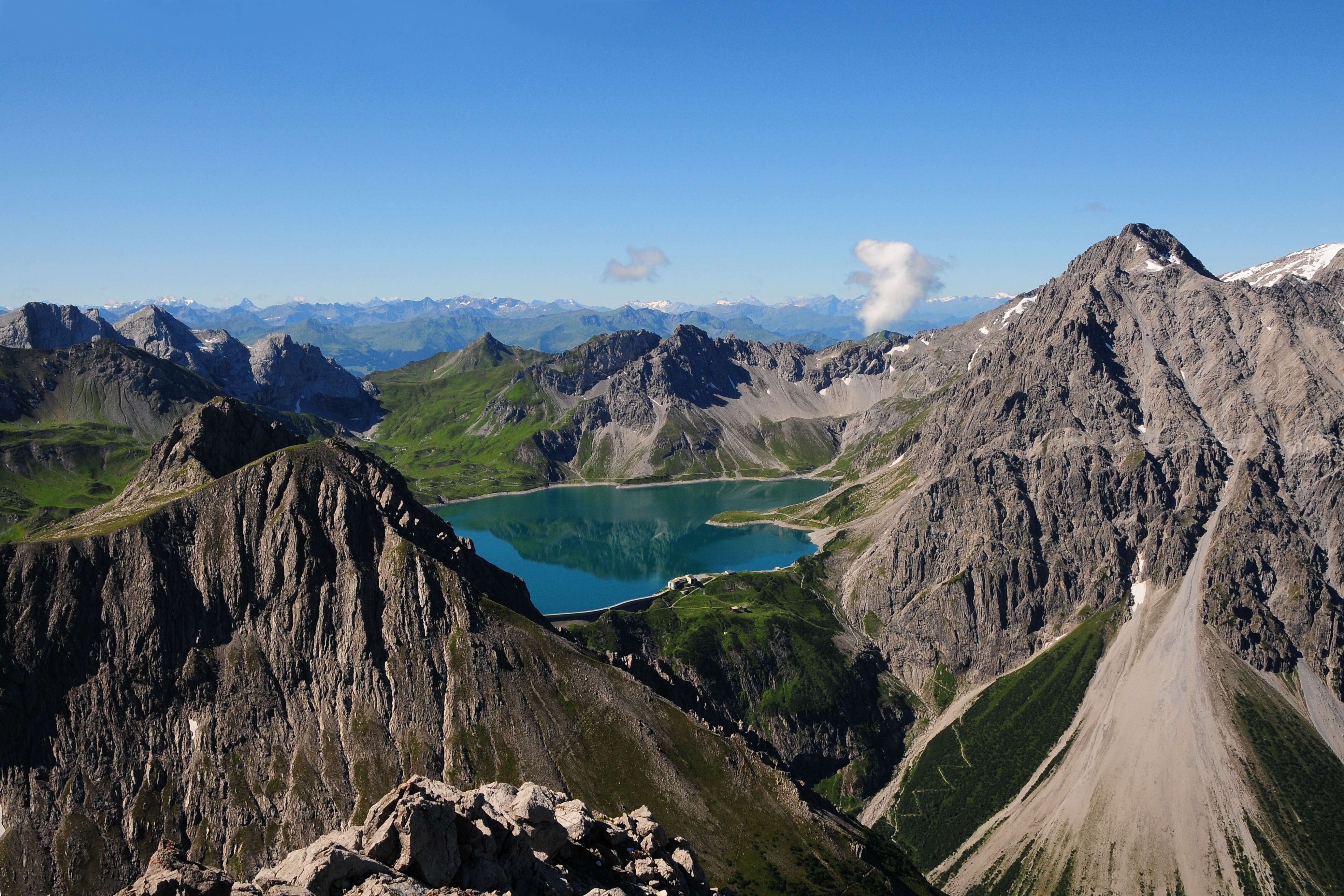
Deutsch: Der Lünersee, gesehen vom Saulakopf 2.517 m. Links der Schafgafall 2.414 m und rechts der Seekopf 2.698 m mit dem Schuttkegel, der bis zur Talstation der Lünerseebahn reicht. Hinter dem See die Kanzelköpfe 2.437 m und auf Schweizer Gebiet (der spitze Berg) die Girenspitze mit 2.394 m.
English: The Lüner Lake, seen from Mt. Saulakopf (2,517 m) in Austria. Left is Mt. Schafgafall (2,414 m) and right Mt. Seekopf (2.698 m). Behind the lake are Mt. Kanzelköpfe (2,437 m) and Mt. Girenspitze (2,394 m) in Switzerland.
Français : Le lac de Lüner (Lünersee) en Autriche, vu du Saulakopf (Tête de cochon).
Sunda: Talaga Lüner ditempo ti Gn. Saulakopf (2.517 m) di Austria. Di beulah kénca Gn. Schafgafall (2.414 m), beulah katuhu Gn. Seekopf (2.698 m). Anu di tukangeun talaga, Gn. Kanzelköpfe (2.437 m) jeung Gn. Girenspitze (2.394 m) mah kaasup wilayah Suis. |
| تاریخ | |
| منبع | اثر شخصی |
| پدیدآور | böhringer friedrich |
| اجازهنامه (استفادهٔ مجدد از این پرونده) |
من، صاحب حقوق قانونی این اثر، به این وسیله این اثر را تحث اجازهنامهٔ ذیل منتشر میکنم: این پرونده با اجازهنامهٔ کریتیو کامانز Attribution-Share Alike 2.5 عمومی منتشر شده است.
|
|

This Photo was taken by Böhringer Friedrich.
|
Feel free to use my photos, but please mention me as the author and if you want send me a message. or (rufre@lenz-nenning.at) |
| مختصات دوربین | | محل قرارگیری این نگاره و سایر نگارهها در: نقشهٔ شهری باز |
|---|
این نگاره با توجه به رهنمودهای نگاره باکیفیت ارزیابیشده و نگارهٔ باکیفیت در نظر گرفته شدهاست.
|
تاریخچهٔ پرونده
روی تاریخ/زمانها کلیک کنید تا نسخهٔ مربوط به آن هنگام را ببینید.
| تاریخ/زمان | بندانگشتی | ابعاد | کاربر | توضیح | |
|---|---|---|---|---|---|
| کنونی | ۶ اوت ۲۰۱۰، ساعت ۲۱:۳۲ | | ۴٬۱۲۵ در ۲٬۷۵۰ (۶٫۳۴ مگابایت) | Böhringer (بحث | مشارکتها) | Excellent picture (but please remove the white dot in the middle of the upper edge) erledigt |
| ۲ اوت ۲۰۱۰، ساعت ۲۲:۰۶ |  | ۴٬۱۲۵ در ۲٬۷۵۰ (۶٫۳۳ مگابایت) | Böhringer (بحث | مشارکتها) | {{Information |Description= {{de| Der Lünersee, gesehen vom Saulakopf 2.517m. Links der Schafgafall 2.414m und rechts der Seekopf 2.698m mit dem Schuttkegel, der bis zur Talstation der Lünerseebahn reicht. Hinter dem | |
| ۱ اوت ۲۰۱۰، ساعت ۲۱:۳۶ |  | ۴٬۲۸۸ در ۲٬۸۴۸ (۷٫۷۴ مگابایت) | Böhringer (بحث | مشارکتها) | {{Information |Description= {{de| Der Lünersee, gesehen vom Saulakopf 2.517m. Links der Schafgafall 2.414m und rechts der Seekopf 2.698m mit dem Schuttkegel, der bis zur Talstation der Lünerseebahn reicht. Hinter dem |
شما نمیتوانید این پرونده را رونویسی کنید.
کاربرد پرونده
صفحههای زیر از این تصویر استفاده میکنند:
- Exzellente Bilder aus Vorarlberg
- Vorarlberg
- User:Böhringer
- User:Böhringer/Archive 3
- User:Ö/Best/2010
- Commons:Featured picture candidates/File:Lünersee vom Saulakopf 1.JPG
- Commons:Featured picture candidates/Log/August 2010
- Commons:Featured pictures/Places/Natural/Austria
- Commons:Featured pictures/chronological/2010-B
- Commons:Picture of the Year/2010/Galleries/Index/9
- Commons:Picture of the Year/2010/Galleries/Index/Nature views
- Commons:Picture of the Year/2010/Galleries/Nature views
- Commons:Picture of the Year/2010/Galleries/Nature views/Large
- Commons:Picture of the Year/2010/Galleries/Nature views/Small
- Commons:Picture of the Year/2010/Galleries/Table
- Commons:Picture of the Year/2010/Galleries/Table/08
- Commons:Picture of the Year/2010/R1/File:Lünersee vom Saulakopf 1.JPG
- Commons:Picture of the Year/2010/Results/R1/ALL/Table
- Commons:Picture of the Year/2010/Results/R1/Nature views
- Commons:Picture of the Year/2010/Results/R1/Nature views/Table
- Commons:Quality images/Subject/Places/Natural structures/archive 2008 to 2012
- Commons:Quality images candidates/Archives August 2010
- Commons talk:Picture of the Year/2010/Galleries/Table
- Commons talk:Picture of the Year/2010/Results/R1/ALL/Table
کاربرد سراسری پرونده
ویکیهای دیگر زیر از این پرونده استفاده میکنند:
- کاربرد در ar.wikipedia.org
- کاربرد در de.wikipedia.org
- کاربرد در en.wikipedia.org
- کاربرد در es.wikipedia.org
- کاربرد در fa.wikipedia.org
- کاربرد در fr.wikipedia.org
- کاربرد در nl.wikipedia.org
- کاربرد در pl.wikipedia.org
- کاربرد در pnb.wikipedia.org
- کاربرد در simple.wikipedia.org
- کاربرد در sq.wikipedia.org
- کاربرد در su.wikipedia.org
- کاربرد در sv.wikipedia.org
- کاربرد در uk.wikipedia.org
- کاربرد در vi.wikipedia.org