File:LA2-Rivers of western Russia.png
- Fichier
- Historique du fichier
- Utilisations locales du fichier
- Utilisations du fichier sur d’autres wikis
- Métadonnées

Fichier d’origine (1 274 × 1 178 pixels, taille du fichier : 263 kio, type MIME : image/png)
Légendes
Légendes
Description
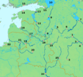
[modifier]| DescriptionLA2-Rivers of western Russia.png | Map of western Russia, with national borders marked (brown), rivers emphasized (dark blue) and major cities (pink) numbered (black). Bounding box West 19°, South 50°, East 40°, North 61°. Center at 55°30′00″N 29°30′00″E / 55.50000°N 29.50000°E / 55.50000; 29.50000. | ||||||
| Date | |||||||
| Source | Based on a public domain map from the Demis map server. Markup added by LA2. | ||||||
| Auteur | LA2 | ||||||
| Autorisation (Réutilisation de ce fichier) |
|
||||||
| Autres versions |
Œuvres dérivées de ce fichier : |
Legend
[modifier]Moscow (1) is situated on the Moskva River, which at Kolomna (3) joins the Oka River, coming from Oryol (2) and continuing west to Ryazan (4).
Europe's longest river, the Volga, originates in the Valdai Hills (5), passes Tver (6) and Rybinsk (7). Both the Oka and the Volga continue east, beyond this map.
The River Lovat originates in northern Belarus, passes Velikiye Luki (8) on its way to lake Ilmen. Further north, the Volkhov River passes the town Veliky Novogorod (9) en route to Europe's largest lake, Lake Ladoga (10). From there, the short Neva River passes Saint Petersburg (11) at the Gulf of Finland.
The Velikaya River passes Pskov (12) at Lake Peipus, from where the short Narva River passes through the town of Narva (13) near the Gulf of Finland. The capitals of Estonia, Tallinn, (14) and of Finland, Helsinki, (15) guard the gulf on opposite sides.
Daugava is the Latvian name of the Zapadnaya Dvina, which passes Vitebsk (16), Daugavpils (17) and ends at Riga (18) at the Gulf of Riga.
The Neris, which passes through Lithuania's capital Vilnius (19) is a tributary of the Neman River, which originates near Minsk (20), the capital of Belarus. The two merge at Kaunas (21). The Neman ends at the Curian Lagoon.
Further south is the city of Kaliningrad/Königsberg (22) on the Pregolya River, which empties into the Vistula Lagoon.
The long Dnieper River passes Smolensk (23) in Russia, runs through Belarus and Kiev (24) in Ukraine before it finally empties into the Black Sea. One of its tributaries is the Desna River which passes Bryansk (25).
Historique du fichier
Cliquer sur une date et heure pour voir le fichier tel qu'il était à ce moment-là.
| Date et heure | Vignette | Dimensions | Utilisateur | Commentaire | |
|---|---|---|---|---|---|
| actuel | 20 mai 2008 à 22:30 |  | 1 274 × 1 178 (263 kio) | LA2 (d | contributions) | {{Information |Description=Map of western Russia, with national borders marked (brown), rivers emphasized (dark blue) and major cities (pink) numbered (black). Bounding box West 19°, South 50°, East 40°, North 61°. Center at {{coor d|55.50000|N|29.500 |
Vous ne pouvez pas remplacer ce fichier.
Utilisations locales du fichier
Les 2 pages suivantes utilisent ce fichier :
Utilisations du fichier sur d’autres wikis
Les autres wikis suivants utilisent ce fichier :
- Utilisation sur ar.wikipedia.org
- Utilisation sur de.wikipedia.org
- Utilisation sur en.wikipedia.org
- Utilisation sur es.wikipedia.org
- Utilisation sur fr.wikipedia.org
- Utilisation sur nn.wikipedia.org
- Utilisation sur pl.wikipedia.org
- Utilisation sur simple.wikipedia.org
- Utilisation sur sr.wikipedia.org
- Utilisation sur sv.wikipedia.org
- Utilisation sur th.wikipedia.org
Métadonnées
Ce fichier contient des informations supplémentaires, probablement ajoutées par l'appareil photo numérique ou le numériseur utilisé pour le créer.
Si le fichier a été modifié depuis son état original, certains détails peuvent ne pas refléter entièrement l'image modifiée.
| Résolution horizontale | 28,35 pt/cm |
|---|---|
| Résolution verticale | 28,35 pt/cm |
| Date de modification du fichier | 20 mai 2008 à 22:23 |