File:League of Nations mandate Middle East and Africa.png
(Redirected from File:LN Mandate Map1.png)
No higher resolution available.
League_of_Nations_mandate_Middle_East_and_Africa.png (200 × 218 pixels, file size: 7 KB, MIME type: image/png)
Captions
Captions
Add a one-line explanation of what this file represents

|
This locator map image could be re-created using vector graphics as an SVG file. This has several advantages; see Commons:Media for cleanup for more information. If an SVG form of this image is available, please upload it and afterwards replace this template with
{{vector version available|new image name}}.
It is recommended to name the SVG file “League of Nations mandate Middle East and Africa.svg”—then the template Vector version available (or Vva) does not need the new image name parameter. |
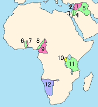
League of Nations Mandate (Middle East and Africa)
- French Mandate of Syria
- French Mandate of Lebanon
- British Mandate of Palestine
- British Mandate of Transjordan
- British Mandate of Iraq
- British Togoland
- French Togoland
- British Cameroon
- French Cameroon
- Ruanda-Urundi
- Tanganyika
- South-West Africa
Created by oxhop

|
Permission is granted to copy, distribute and/or modify this document under the terms of the GNU Free Documentation License, Version 1.2 or any later version published by the Free Software Foundation; with no Invariant Sections, no Front-Cover Texts, and no Back-Cover Texts. A copy of the license is included in the section entitled GNU Free Documentation License. |
| This file is licensed under the Creative Commons Attribution-Share Alike 3.0 Unported license. | ||
| ||
| This licensing tag was added to this file as part of the GFDL licensing update. |
File history
Click on a date/time to view the file as it appeared at that time.
| Date/Time | Thumbnail | Dimensions | User | Comment | |
|---|---|---|---|---|---|
| current | 19:11, 29 December 2009 | | 200 × 218 (7 KB) | Kmusser (talk | contribs) | smoothed ocean shading |
| 12:23, 14 March 2005 |  | 200 × 218 (6 KB) | Oxhop (talk | contribs) | League of Nations Mandate (Middle East & Africa){{GFDL}} |
You cannot overwrite this file.
File usage on Commons
The following 3 pages use this file:
- Atlas of Africa
- Atlas of World War I
- File:LN Mandate Map1.png (file redirect)
File usage on other wikis
The following other wikis use this file:
- Usage on af.wikipedia.org
- Usage on ar.wikipedia.org
- Usage on az.wikipedia.org
- Usage on bn.wiktionary.org
- Usage on ckb.wikipedia.org
- Usage on cs.wikipedia.org
- Usage on da.wikipedia.org
- Usage on de.wikipedia.org
- Usage on el.wikipedia.org
- Usage on en.wikipedia.org
- Usage on en.wiktionary.org
- Usage on eo.wikipedia.org
- Usage on es.wikipedia.org
- Usage on fi.wikipedia.org
- Usage on frr.wikipedia.org
- Usage on fr.wikipedia.org
- Usage on fr.wikiversity.org
- Usage on he.wikipedia.org
- Usage on hu.wikipedia.org
- Usage on id.wikipedia.org
- Usage on it.wikipedia.org
- Usage on ja.wikipedia.org
- Usage on ka.wikipedia.org
- Usage on ko.wikipedia.org
- Usage on lt.wikipedia.org
- Usage on nl.wikipedia.org
- Usage on nn.wikipedia.org
View more global usage of this file.