File:La francophonie mapa.svg
Jump to navigation
Jump to search

Size of this PNG preview of this SVG file: 800 × 353 pixels. Other resolutions: 320 × 141 pixels | 640 × 283 pixels | 1,024 × 452 pixels | 1,280 × 565 pixels | 2,560 × 1,131 pixels | 1,003 × 443 pixels.
Original file (SVG file, nominally 1,003 × 443 pixels, file size: 1.44 MB)
Captions
Captions
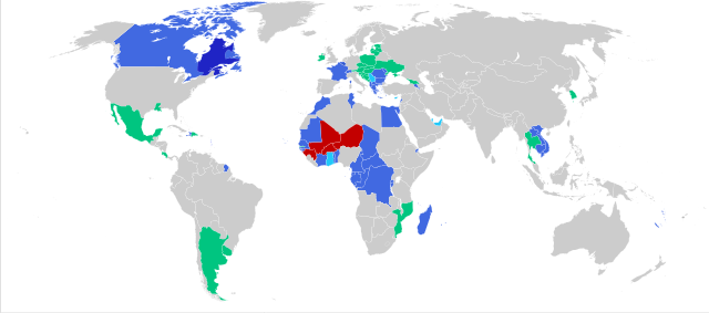
Map of countries within the OIF
Summary
[edit]
| Description |
Français : Carte de la Francophonie
membre (national)
membre (régional)
membre associé
membre suspendu
observateur Español: Mapa de la Francofonía
miembro (nacional)
miembro (regional)
miembro asociado
miembro suspendido
observador English: Map of the Francophonie
member (national)
member (regional)
associated member
suspended member
observer Nederlands: Kaart van de Francofonie
lid (nationaal)
lid (regionaal)
geassocieerd lid
geschorst lid
waarnemer |
| Date | |
| Source | File:Map-Francophonie organisation fr.svg |
| Author | Bourrichon |
What happened to Newfoundland and Labrador 💀
Licensing
[edit]
| I, the copyright holder of this work, release this work into the public domain. This applies worldwide. In some countries this may not be legally possible; if so: I grant anyone the right to use this work for any purpose, without any conditions, unless such conditions are required by law. |
File history
Click on a date/time to view the file as it appeared at that time.
| Date/Time | Thumbnail | Dimensions | User | Comment | |
|---|---|---|---|---|---|
| current | 21:25, 15 November 2023 | | 1,003 × 443 (1.44 MB) | HapHaxion (talk | contribs) | further coup suspensions // Editing SVG source code using c:User:Rillke/SVGedit.js |
| 21:13, 15 November 2023 |  | 1,003 × 443 (1.44 MB) | HapHaxion (talk | contribs) | two suspended due to coups d'etat // Editing SVG source code using c:User:Rillke/SVGedit.js | |
| 09:39, 2 August 2023 |  | 1,003 × 443 (1.44 MB) | Louloumra59 (talk | contribs) | La Thaïlande est un membre observateur qui n'est plus suspendu depuis 2019 | |
| 06:33, 16 March 2023 |  | 1,003 × 443 (1.44 MB) | Kwamikagami (talk | contribs) | resize so can be compared to other lang versions | |
| 19:32, 10 May 2020 |  | 100 × 56 (1.48 MB) | EEIM (talk | contribs) | Uploaded own work with UploadWizard |
You cannot overwrite this file.
File usage
The following 7 pages use this file:
- User:Chumwa/OgreBot/Travel and communication maps/2023 August 1-10
- User:Chumwa/OgreBot/Travel and communication maps/2023 March 11-20
- User:Chumwa/OgreBot/Travel and communication maps/2023 November 11-20
- File:Map-Francophonie organisation.svg (file redirect)
- File:Map-Francophonie organisation en.svg
- File:Map-Francophonie organisation fr.svg
- Category:Organisation internationale de la francophonie
Global file usage
The following other wikis use this file:
- Usage on ar.wikipedia.org
- Usage on ary.wikipedia.org
- Usage on arz.wikipedia.org
- Usage on ast.wikipedia.org
- Usage on be.wikipedia.org
- Usage on bg.wikipedia.org
- Usage on bn.wikipedia.org
- Usage on ca.wikipedia.org
- Usage on ce.wikipedia.org
- Usage on cs.wikipedia.org
- Usage on cy.wikipedia.org
- Usage on da.wikipedia.org
- Usage on de.wikipedia.org
- Usage on diq.wikipedia.org
- Usage on el.wikipedia.org
- Usage on en.wikipedia.org
- Usage on es.wikipedia.org
- Usage on fa.wikipedia.org
- Usage on fi.wikipedia.org
- Usage on fr.wikipedia.org
- Usage on he.wikipedia.org
- Usage on hr.wikipedia.org
- Usage on hu.wikipedia.org
- Usage on hy.wikipedia.org
- Usage on hyw.wikipedia.org
- Usage on it.wikipedia.org
- Usage on ja.wikipedia.org
- Usage on kaa.wikipedia.org
- Usage on ka.wikipedia.org
- Usage on kk.wikipedia.org
- Usage on km.wikipedia.org
View more global usage of this file.