File:La mort de Marat (32663737445).jpg
Jump to navigation
Jump to search
Size of this preview: 468 × 599 pixels. Other resolutions: 187 × 240 pixels | 375 × 480 pixels | 600 × 768 pixels | 800 × 1,024 pixels | 1,600 × 2,048 pixels | 3,106 × 3,975 pixels.
Original file (3,106 × 3,975 pixels, file size: 6.55 MB, MIME type: image/jpeg)
Captions
Captions
Add a one-line explanation of what this file represents
Summary[edit]
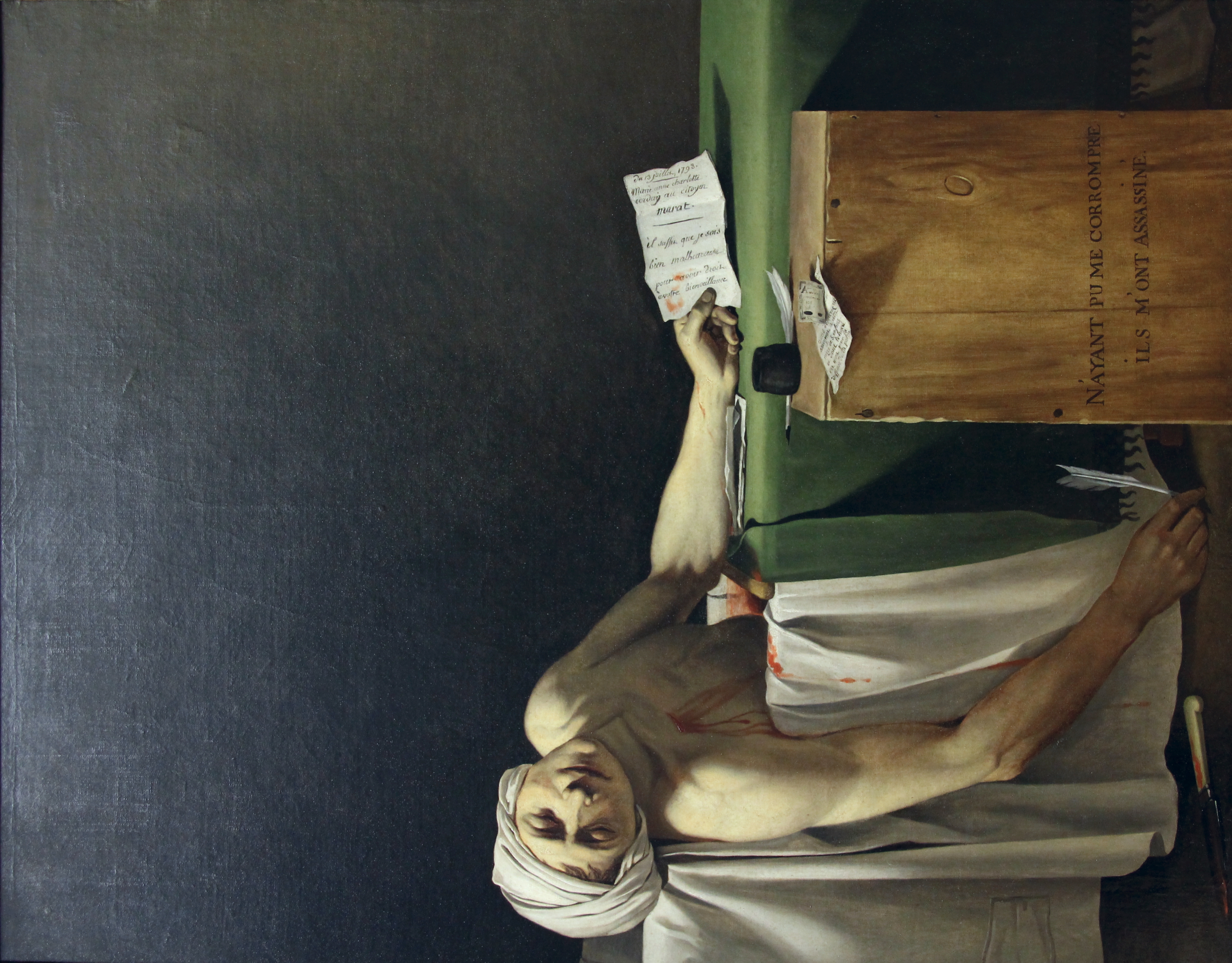
| The Death of Marat
|
|||||||||||||||||||||||||||
|---|---|---|---|---|---|---|---|---|---|---|---|---|---|---|---|---|---|---|---|---|---|---|---|---|---|---|---|
| Artist |
|
.jpg) | |||||||||||||||||||||||||
| Author |
Fred Romero from Paris, France |
||||||||||||||||||||||||||
| Title |
French: Marat assassiné The Death of Marat |
||||||||||||||||||||||||||
| Object type |
painting |
||||||||||||||||||||||||||
| Genre |
history painting |
||||||||||||||||||||||||||
| Description |
Sully wing: "La Mort de Marat", probably by Gioacchino Serangeli, c.1793, a copy of the original from Jacques Louis David. |
||||||||||||||||||||||||||
| Depicted people |
Jean-Paul Marat |
||||||||||||||||||||||||||
| Date | Taken on 9 December 2016, 18:56 | ||||||||||||||||||||||||||
| Medium |
oil on canvas |
||||||||||||||||||||||||||
| Dimensions |
height: 162.5 cm (63.9 in) |
||||||||||||||||||||||||||
| Collection |
|
||||||||||||||||||||||||||
| Current location | |||||||||||||||||||||||||||
| Accession number |
RF 1945-2 and RF 1945 2 (Department of Paintings of the Louvre) |
||||||||||||||||||||||||||
| References | |||||||||||||||||||||||||||
| Authority file | |||||||||||||||||||||||||||
| Source/Photographer | Paris - Musée du Louvre | ||||||||||||||||||||||||||
| Other versions |
|
||||||||||||||||||||||||||


.jpg&action=edit§ion=1)
| Camera location | | View this and other nearby images on: OpenStreetMap |
|---|
.jpg¶ms=048.860134_N_0002.339433_E_globe:Earth_type:camera_source:Flickr_&language=en)
Licensing[edit]
.jpg&action=edit§ion=2)
This file is licensed under the Creative Commons Attribution 2.0 Generic license.
- You are free:
- to share – to copy, distribute and transmit the work
- to remix – to adapt the work
- Under the following conditions:
- attribution – You must give appropriate credit, provide a link to the license, and indicate if changes were made. You may do so in any reasonable manner, but not in any way that suggests the licensor endorses you or your use.
| This image was originally posted to Flickr by corno.fulgur75 at https://flickr.com/photos/129231073@N06/32663737445 (archive). It was reviewed on 2 January 2018 by FlickreviewR 2 and was confirmed to be licensed under the terms of the cc-by-2.0. |
File history
Click on a date/time to view the file as it appeared at that time.
| Date/Time | Thumbnail | Dimensions | User | Comment | |
|---|---|---|---|---|---|
| current | 06:21, 2 January 2018 | | 3,106 × 3,975 (6.55 MB) | Paris 16 (talk | contribs) | Transferred from Flickr via Flickr2Commons |
You cannot overwrite this file.
File usage on Commons
The following 23 pages use this file:
- User:Paris 16/Recent uploads/2018 January 1-2
- File:Death of Marat by David.jpg
- File:Death of Marat by David (cropped).jpg
- File:Death of Marat by David (cropped 4-3).jpg
- File:Death of Marat by David (detail).jpg
- File:Death of Marat by David (face and wound).jpg
- File:Jacques-Louis David - De moord op Marat - MSK Brussel 25-02-2011 13-11-35.jpg
- File:Jacques-Louis David - La Mort de Marat.jpg
- File:Jacques-Louis David - Marat assassinated - Google Art Project.jpg
- File:Jacques-Louis David - Marat assassinated - Google Art Project 2.jpg
- File:Jacques-Louis David - Marat assassinated - Google Art Project 2FXD.jpg
- File:Jacques-Louis David - Marat assassiné.jpg
- File:Jacques-Louis David 002.jpg
- File:Jacques-louis david, la morte di marat, 1793, 01.jpg
- File:Jacques-louis david, la morte di marat, 1793, 02.jpg
- File:Jacques-louis david, la morte di marat, 1793, 03.jpg
- File:Jacques-louis david, la morte di marat, 1793, 04.jpg
- File:Jacques-louis david, la morte di marat, 1793, 05 lettera.jpg
- File:Jacques-louis david, marat assassinato, 1794, 01.jpg
- File:La mort de Marat (32663737445).jpg
- File:One Hundred Masterpieces of Art (Bulgakov) - il. 31.jpg
- File:Paris - Musée du Louvre (32663737445).jpg (file redirect)
- Category:La mort de Marat (Louvre RF 1945 2)
.jpg)
.jpg)
.jpg)
.jpg)
_-_il._31.jpg)
.jpg&redirect=no)
File usage on other wikis
The following other wikis use this file:
- Usage on www.wikidata.org
.jpg&oldid=844266480)