File:Lakeside Mountains, Utah (21695777605).jpg

Original file (4,000 × 3,000 pixels, file size: 2.14 MB, MIME type: image/jpeg)
Captions
Captions
Summary
[edit].jpg&action=edit§ion=1)
| Description |
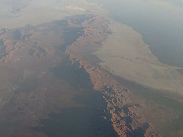
The Lakeside Mountains are about a 34-mile-long (55 km) mountain range located on the southwest perimeter of the Great Salt Lake; the range is located in northeast Tooele County, Utah, and south Box Elder County. The range consists of a 13-mile-long north-trending section, and a southeast stretch composed of variable-height peaks and lower elevations, as well as a massif section containing the mountain range highpoint. The north section of the range terminus is at the community of Lakeside, Utah, and the region lies on an eastern border of the Great Salt Lake Desert. The range is linear, with the two trending sections. The north section actually trends slightly north-northeast, with the south part of it as a mountain area, with Sally Mountain, 5,855 feet (1,785 m); north of it, the range turns into ridgelines and small parallel valleys. Interstate 80 crosses the southern terminus of the Lakeside Mountains, at the townsite of Delle. A northwest stretch of I-80 from Delle, skirts the range foothills, then enters the north of the Cedar Mountains, before turning west through the Great Salt Lake Desert. From the north Cedar Mountains, Puddle Valley Highway (improved road) transits due-north through Puddle Valley, then enters the west flank region of the north section of the range; a small valley called "Death Valley", located in a hilly foothill region, borders the Great Salt Lake Desert, on the desert's east, about 3 mi; Death Ridge, a subridge is 1 mi east; the north mountain terminus near Lakeside continues as named: Scad Ridge, Sedal Valley, Cave Ride, Great Salt Lake shoreline, (all 1 mi apart from each other). <a href="https://en.wikipedia.org/wiki/Lakeside_Mountains" rel="noreferrer nofollow">en.wikipedia.org/wiki/Lakeside_Mountains</a> <a href="https://en.wikipedia.org/wiki/Wikipedia:Text_of_Creative_Commons_Attribution-ShareAlike_3.0_Unported_License" rel="noreferrer nofollow">en.wikipedia.org/wiki/Wikipedia:Text_of_Creative_Commons_...</a> |
| Date | Taken on 24 September 2015, 06:54 |
| Source | Lakeside Mountains, Utah |
| Author | Ken Lund from Reno, Nevada, USA |
| Camera location | | View this and other nearby images on: OpenStreetMap |
|---|
.jpg¶ms=041.005033_N_-112.884479_E_globe:Earth_type:camera_source:Flickr_&language=en)
Licensing
[edit].jpg&action=edit§ion=2)
- You are free:
- to share – to copy, distribute and transmit the work
- to remix – to adapt the work
- Under the following conditions:
- attribution – You must give appropriate credit, provide a link to the license, and indicate if changes were made. You may do so in any reasonable manner, but not in any way that suggests the licensor endorses you or your use.
- share alike – If you remix, transform, or build upon the material, you must distribute your contributions under the same or compatible license as the original.
| This image was originally posted to Flickr by Ken Lund at https://flickr.com/photos/75683070@N00/21695777605. It was reviewed on 31 March 2022 by FlickreviewR 2 and was confirmed to be licensed under the terms of the cc-by-sa-2.0. |
File history
Click on a date/time to view the file as it appeared at that time.
| Date/Time | Thumbnail | Dimensions | User | Comment | |
|---|---|---|---|---|---|
| current | 23:44, 31 March 2022 | | 4,000 × 3,000 (2.14 MB) | Animalparty (talk | contribs) | Transferred from Flickr via #flickr2commons |
You cannot overwrite this file.
File usage on Commons
The following page uses this file:
File usage on other wikis
The following other wikis use this file:
- Usage on arz.wikipedia.org
- Usage on ceb.wikipedia.org
- Usage on en.wikipedia.org
- Usage on www.wikidata.org
.jpg&oldid=880252357)