File:Lancashire UK locator map 2010.svg
Ir a la navegación
Ir a la búsqueda

Tamaño de esta previsualización PNG del archivo SVG: 494 × 600 píxeles. Otras resoluciones: 198 × 240 píxeles | 395 × 480 píxeles | 633 × 768 píxeles | 843 × 1024 píxeles | 1687 × 2048 píxeles | 1108 × 1345 píxeles.
Archivo original (archivo SVG, nominalmente 1108 × 1345 píxeles, tamaño de archivo: 302 kB)
Leyendas
Leyendas
Añade una explicación corta acerca de lo que representa este archivo
Юююююю .
Че
Resumen
[editar]
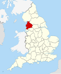
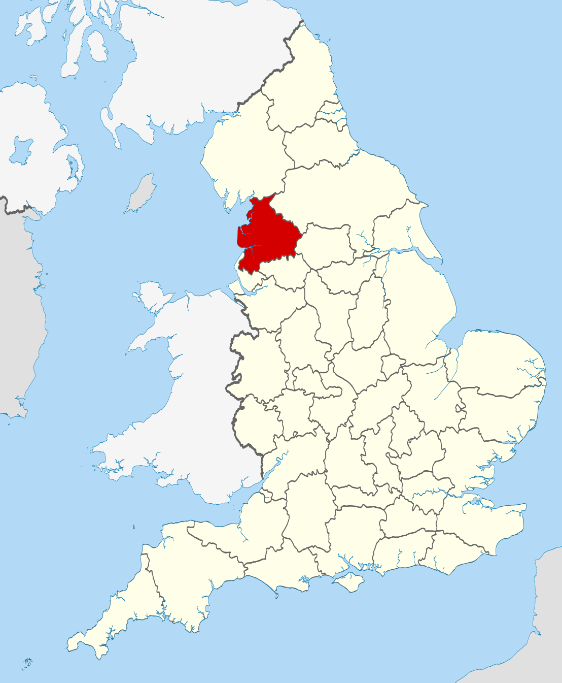
| Descripción | Location of the ceremonial county of Lancashire within England. |
| Fecha | |
| Fuente |
National Geospatial-Intelligence Agency
|
| Autor | Nilfanion |
Licencia
[editar]
Yo, titular de los derechos de autor de esta obra, la publico en los términos de las siguientes licencias:
Este archivo se encuentra bajo la licencia Creative Commons Genérica de Atribución/Compartir-Igual 3.0.
- Eres libre:
- de compartir – de copiar, distribuir y transmitir el trabajo
- de remezclar – de adaptar el trabajo
- Bajo las siguientes condiciones:
- atribución – Debes otorgar el crédito correspondiente, proporcionar un enlace a la licencia e indicar si realizaste algún cambio. Puedes hacerlo de cualquier manera razonable pero no de manera que sugiera que el licenciante te respalda a ti o al uso que hagas del trabajo.
- compartir igual – En caso de mezclar, transformar o modificar este trabajo, deberás distribuir el trabajo resultante bajo la misma licencia o una compatible como el original.

|
Se autoriza la copia, distribución y modificación de este documento bajo los términos de la licencia de documentación libre GNU, versión 1.2 o cualquier otra que posteriormente publique la Fundación para el Software Libre; sin secciones invariables, textos de portada, ni textos de contraportada. Se incluye una copia de la dicha licencia en la sección titulada Licencia de Documentación Libre GNU. |
Puedes usar la licencia que prefieras.

|
This is one of the images forming part of the Valued image set: Locator maps of the Ceremonial counties of England on Wikimedia Commons. The image set has been assessed under the valued image set criteria and is considered the most valued set on Commons within the scope:
Locator maps of the Ceremonial counties of England
You can see its nomination at Commons:Valued image candidates/Locator maps of English ceremonial counties. |
Historial del archivo
Haz clic sobre una fecha y hora para ver el archivo tal como apareció en ese momento.
| Fecha y hora | Miniatura | Dimensiones | Usuario | Comentario | |
|---|---|---|---|---|---|
| actual | 22:39 23 nov 2010 | | 1108 × 1345 (302 kB) | Nilfanion (discusión | contribs.) | == Summary == {{Information |Description=Location of the ceremonial county of Lancashire within England. |Source=Ordnance Survey [https://www.ordnancesurvey.co.uk/opendatadownload/products.html OpenData]: *County bou |
No puedes sobrescribir este archivo.
Usos del archivo
Las siguientes páginas usan este archivo:
- Valued image set: Locator maps of the Ceremonial counties of England
- Commons:Valued image candidates/Locator maps of English ceremonial counties
- Category:Alumni by school in Lancashire
- Category:Archaeological sites in Lancashire
- Category:Bridges in Lancashire
- Category:Bus stations in Lancashire
- Category:Canals in Lancashire
- Category:Cemeteries in Lancashire
- Category:Deaths in Lancashire
- Category:Forests in Lancashire
- Category:Geography of Lancashire
- Category:Hospitals in Lancashire
- Category:Lancashire
- Category:Lancashire in the 17th century
- Category:Lancashire in the 1830s
- Category:Lancashire in the 1840s
- Category:Lancashire in the 1850s
- Category:Lancashire in the 1860s
- Category:Lancashire in the 1880s
- Category:Lancashire in the 1890s
- Category:Lancashire in the 18th century
- Category:Lancashire in the 1900s
- Category:Lancashire in the 1910s
- Category:Lancashire in the 1920s
- Category:Lancashire in the 1930s
- Category:Lancashire in the 1940s
- Category:Lancashire in the 1950s
- Category:Lancashire in the 1960s
- Category:Lancashire in the 1970s
- Category:Lancashire in the 1980s
- Category:Lancashire in the 1990s
- Category:Lancashire in the 19th century
- Category:Lancashire in the 2000s
- Category:Lancashire in the 2010s
- Category:Lancashire in the 20th century
- Category:Lancashire in the 21st century
- Category:Maps of Lancashire
- Category:People of Lancashire
- Category:Populated places in Lancashire
- Category:Prisons in Lancashire
- Category:Rail transport in Lancashire
- Category:Railway viaducts in Lancashire
- Category:Rivers of Lancashire
- Category:Roads in Lancashire
- Category:Sports in Lancashire
- Category:Towers in Lancashire
- Category:Views of Lancashire
- Category:Villages in Lancashire
- Category:Visitor attractions in Lancashire
- Category:Windmills in Lancashire
Uso global del archivo
Las wikis siguientes utilizan este archivo:
- Uso en af.wikipedia.org
- Uso en ar.wikipedia.org
- Uso en ast.wikipedia.org
- Uso en az.wikipedia.org
- Uso en be-tarask.wikipedia.org
- Uso en be.wikipedia.org
- Uso en bg.wikipedia.org
- Uso en br.wikipedia.org
- Uso en ca.wikipedia.org
- Uso en ceb.wikipedia.org
- Uso en cs.wikipedia.org
- Uso en en.wikipedia.org
- Lancashire
- National nature reserves in Lancashire
- Grit Fell
- Wolfhole Crag
- Fair Snape Fell
- Leyland Hundred
- Lonsdale Hundred
- Bleasdale
- Knott End-on-Sea
- Great Altcar
- Trawden
- White Hill (Forest of Bowland)
- Hawthornthwaite Fell
- Gambleside
- Brownhill
- Catforth
- Over Wyre
- Oakenshaw, Lancashire
- Langho
- River Tawd
- Downholland Cross
- Haskayne
- Farington
- Salwick
- Barrow Nook
- Foulridge
- Wennington, Lancashire
- Template:Lancashire-geo-stub
- Eagland Hill
- Yarrow Valley Country Park
- Quernmore
- Central Lancashire
- Whittington, Lancashire
- River Hyndburn
- Barley-with-Wheatley Booth
- Barnacre-with-Bonds
- Bickerstaffe
- Municipal Borough of Morecambe and Heysham
Ver más uso global de este archivo.