File:Lancashire UK locator map 2010.svg
Aller à la navigation
Aller à la recherche

Taille de cet aperçu PNG pour ce fichier SVG : 494 × 600 pixels. Autres résolutions : 198 × 240 pixels | 395 × 480 pixels | 633 × 768 pixels | 843 × 1 024 pixels | 1 687 × 2 048 pixels | 1 108 × 1 345 pixels.
Fichier d’origine (Fichier SVG, nominalement de 1 108 × 1 345 pixels, taille : 302 kio)
Légendes
Légendes
Ajoutez en une ligne la description de ce que représente ce fichier
Юююююю .
Че
Description
[modifier]
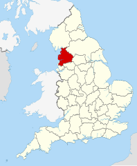
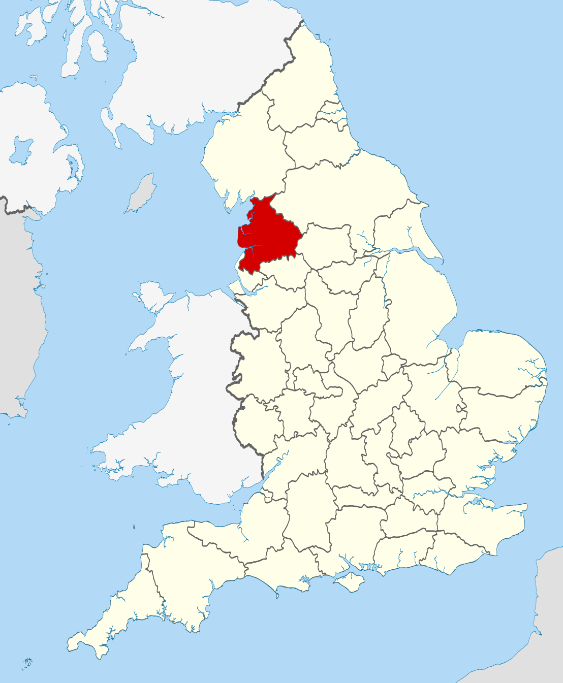
| Description | Location of the ceremonial county of Lancashire within England. |
| Date | |
| Source |
National Geospatial-Intelligence Agency
|
| Auteur | Nilfanion |
Conditions d’utilisation
[modifier]
Moi, en tant que détenteur des droits d’auteur sur cette œuvre, je la publie sous les licences suivantes :
Ce fichier est disponible selon les termes de la licence Creative Commons Attribution – Partage dans les Mêmes Conditions 3.0 (non transposée).
- Vous êtes libre :
- de partager – de copier, distribuer et transmettre cette œuvre
- d’adapter – de modifier cette œuvre
- Sous les conditions suivantes :
- paternité – Vous devez donner les informations appropriées concernant l'auteur, fournir un lien vers la licence et indiquer si des modifications ont été faites. Vous pouvez faire cela par tout moyen raisonnable, mais en aucune façon suggérant que l’auteur vous soutient ou approuve l’utilisation que vous en faites.
- partage à l’identique – Si vous modifiez, transformez, ou vous basez sur cette œuvre, vous devez distribuer votre contribution sous la même licence ou une licence compatible avec celle de l’original.

|
Vous avez la permission de copier, distribuer et modifier ce document selon les termes de la GNU Free Documentation License version 1.2 ou toute version ultérieure publiée par la Free Software Foundation, sans sections inaltérables, sans texte de première page de couverture et sans texte de dernière page de couverture. Un exemplaire de la licence est inclus dans la section intitulée GNU Free Documentation License. |
Vous pouvez choisir l’une de ces licences.

|
Ceci est une des images constituant une partie de l'ensemble d'images de valeur : Locator maps of the Ceremonial counties of England, sur Wikimedia Commons. Le groupe d'images a été validé selon les critères pour les ensembles d'images de valeur et a été considéré comme étant l'ensemble possédant la plus grande valeur sur Commons dans la thématique :
Locator maps of the Ceremonial counties of England
Vous pouvez consulter la proposition sur Commons:Valued image candidates/Locator maps of English ceremonial counties. |
Historique du fichier
Cliquer sur une date et heure pour voir le fichier tel qu'il était à ce moment-là.
| Date et heure | Vignette | Dimensions | Utilisateur | Commentaire | |
|---|---|---|---|---|---|
| actuel | 23 novembre 2010 à 22:39 | | 1 108 × 1 345 (302 kio) | Nilfanion (d | contributions) | == Summary == {{Information |Description=Location of the ceremonial county of Lancashire within England. |Source=Ordnance Survey [https://www.ordnancesurvey.co.uk/opendatadownload/products.html OpenData]: *County bou |
Vous ne pouvez pas remplacer ce fichier.
Utilisations locales du fichier
Les 50 pages suivantes utilisent ce fichier :
- Valued image set: Locator maps of the Ceremonial counties of England
- Commons:Valued image candidates/Locator maps of English ceremonial counties
- Category:Alumni by school in Lancashire
- Category:Archaeological sites in Lancashire
- Category:Bridges in Lancashire
- Category:Bus stations in Lancashire
- Category:Canals in Lancashire
- Category:Cemeteries in Lancashire
- Category:Deaths in Lancashire
- Category:Forests in Lancashire
- Category:Geography of Lancashire
- Category:Hospitals in Lancashire
- Category:Lancashire
- Category:Lancashire in the 17th century
- Category:Lancashire in the 1830s
- Category:Lancashire in the 1840s
- Category:Lancashire in the 1850s
- Category:Lancashire in the 1860s
- Category:Lancashire in the 1880s
- Category:Lancashire in the 1890s
- Category:Lancashire in the 18th century
- Category:Lancashire in the 1900s
- Category:Lancashire in the 1910s
- Category:Lancashire in the 1920s
- Category:Lancashire in the 1930s
- Category:Lancashire in the 1940s
- Category:Lancashire in the 1950s
- Category:Lancashire in the 1960s
- Category:Lancashire in the 1970s
- Category:Lancashire in the 1980s
- Category:Lancashire in the 1990s
- Category:Lancashire in the 19th century
- Category:Lancashire in the 2000s
- Category:Lancashire in the 2010s
- Category:Lancashire in the 20th century
- Category:Lancashire in the 21st century
- Category:Maps of Lancashire
- Category:People of Lancashire
- Category:Populated places in Lancashire
- Category:Prisons in Lancashire
- Category:Rail transport in Lancashire
- Category:Railway viaducts in Lancashire
- Category:Rivers of Lancashire
- Category:Roads in Lancashire
- Category:Sports in Lancashire
- Category:Towers in Lancashire
- Category:Views of Lancashire
- Category:Villages in Lancashire
- Category:Visitor attractions in Lancashire
- Category:Windmills in Lancashire
Utilisations du fichier sur d’autres wikis
Les autres wikis suivants utilisent ce fichier :
- Utilisation sur af.wikipedia.org
- Utilisation sur ar.wikipedia.org
- Utilisation sur ast.wikipedia.org
- Utilisation sur az.wikipedia.org
- Utilisation sur be-tarask.wikipedia.org
- Utilisation sur be.wikipedia.org
- Utilisation sur bg.wikipedia.org
- Utilisation sur br.wikipedia.org
- Utilisation sur ca.wikipedia.org
- Utilisation sur ceb.wikipedia.org
- Utilisation sur cs.wikipedia.org
- Utilisation sur en.wikipedia.org
- Lancashire
- National nature reserves in Lancashire
- Grit Fell
- Wolfhole Crag
- Fair Snape Fell
- Leyland Hundred
- Lonsdale Hundred
- Bleasdale
- Knott End-on-Sea
- Great Altcar
- Trawden
- White Hill (Forest of Bowland)
- Hawthornthwaite Fell
- Gambleside
- Brownhill
- Catforth
- Over Wyre
- Oakenshaw, Lancashire
- Langho
- River Tawd
- Downholland Cross
- Haskayne
- Farington
- Salwick
- Barrow Nook
- Foulridge
- Wennington, Lancashire
- Template:Lancashire-geo-stub
- Eagland Hill
- Yarrow Valley Country Park
- Quernmore
- Central Lancashire
- Whittington, Lancashire
- River Hyndburn
- Barley-with-Wheatley Booth
- Barnacre-with-Bonds
- Bickerstaffe
- Municipal Borough of Morecambe and Heysham
Voir davantage sur l’utilisation globale de ce fichier.