File:Landing zone 'N' 7 June 1944.jpg
پرش به ناوبری
پرش به جستجو
اندازهٔ این پیشنمایش: ۶۴۶ × ۵۹۹ پیکسل. کیفیتهای دیگر: ۲۵۹ × ۲۴۰ پیکسل | ۵۱۸ × ۴۸۰ پیکسل.
پروندهٔ اصلی (۸۰۰ × ۷۴۲ پیکسل، اندازهٔ پرونده: ۸۶ کیلوبایت، نوع MIME پرونده: image/jpeg)
گزینهها
عنوان
شرحی یکخطی از محتوای این فایل اضافه کنید
| توضیح |
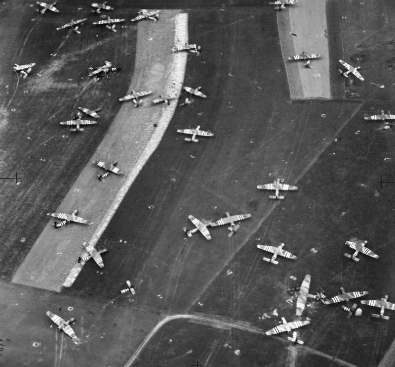
English: Oblique photographic-reconnaissance vertical, taken from 800 feet, showing part of Landing Zone 'N', north of Ranville, Normandy, on the day following Operation MALLARD : the airborne landing of 6th Airlanding Brigade and the Airborne Armoured Reconnaissance Regiment in the evening of 6 June 1944. Airspeed Horsa troop-carrying gliders and one damaged GAL Hamilcar tank-carrying glider (lower right) litter this part of the LZ close to the Ranville-Salanelles road. |
|||
| تاریخ | ||||
| منبع |
|
|||
| پدیدآور | Kelly (Flt Lt): No. 106 (PR) Group. | |||
| اجازهنامه (استفادهٔ مجدد از این پرونده) |
|


سیاهه بارگذاری اصلی
[ویرایش]
Transferred from en.wikipedia to Commons by Rcbutcher using CommonsHelper.
صفحهٔ اصلی توضیحات اینجابود. همهٔ نامهای کاربر زیر به en.wikipedia اشاره دارند.
- 2011-05-17 11:43 Jncraton 300×256× (16465 bytes) Lossless crop to remove watermark
- 2011-05-03 19:40 Jim Sweeney 300×277× (18111 bytes) {{Information | description = Oblique photographic-reconnaissance vertical, taken from 800 feet, showing part of Landing Zone 'N', north of Ranville, Normandy, on the day following Operation MALLARD: the airborne landing of [[6th Airlanding Brigade]] and
تاریخچهٔ پرونده
روی تاریخ/زمانها کلیک کنید تا نسخهٔ مربوط به آن هنگام را ببینید.
| تاریخ/زمان | بندانگشتی | ابعاد | کاربر | توضیح | |
|---|---|---|---|---|---|
| کنونی | ۲۳ ژوئیهٔ ۲۰۱۲، ساعت ۰۷:۵۳ | | ۸۰۰ در ۷۴۲ (۸۶ کیلوبایت) | Rcbutcher (بحث | مشارکتها) | replaced with new higher-quality version from IWM |
| ۲۳ ژوئیهٔ ۲۰۱۲، ساعت ۰۷:۴۵ |  | ۳۰۰ در ۲۵۶ (۱۶ کیلوبایت) | File Upload Bot (Magnus Manske) (بحث | مشارکتها) | Transfered from en.wikipedia by User:rcbutcher using CommonsHelper |
شما نمیتوانید این پرونده را رونویسی کنید.
کاربرد پرونده
صفحههای زیر از این تصویر استفاده میکنند:
کاربرد سراسری پرونده
ویکیهای دیگر زیر از این پرونده استفاده میکنند:
- کاربرد در en.wikipedia.org
- کاربرد در fa.wikipedia.org
- کاربرد در fr.wikipedia.org
- کاربرد در pl.wikipedia.org
- کاربرد در th.wikipedia.org
- کاربرد در www.wikidata.org