File:Landsat-emirau-island-adjusted.png
Jump to navigation
Jump to search
No higher resolution available.
Landsat-emirau-island-adjusted.png (568 × 348 pixels, file size: 774 KB, MIME type: image/png)
Captions
Captions
Add a one-line explanation of what this file represents
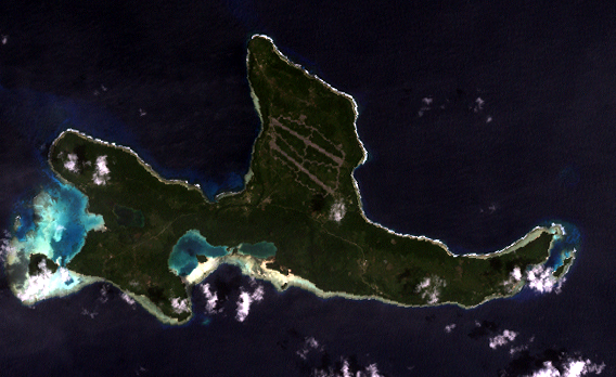
Orthocorrected Landsat 7 image of Emirau Island, New Ireland province, Papua New Guinea. Acquired 2000-II-6; orthocorrected by EarthSat. Source for this dataset was the Global Land Cover Facility archive copy at the Wayback Machine. Levels have been adjusted using GIMP. This is a public domain image.
This image is in the public domain in the United States because it only contains materials that originally came from the United States Geological Survey, an agency of the United States Department of the Interior. For more information, see the official USGS copyright policy.
|
File history
Click on a date/time to view the file as it appeared at that time.
| Date/Time | Thumbnail | Dimensions | User | Comment | |
|---|---|---|---|---|---|
| current | 18:00, 14 May 2005 | | 568 × 348 (774 KB) | Dmoews~commonswiki (talk | contribs) | Orthocorrected Landsat 7 image of Emirau Island, New Ireland province, Papua New Guinea. Acquired 2000-II-6; orthocorrected by [http://www.earthsat.com/ EarthSat]. Source for this dataset was the [http://www.landcover.org/ Global Land Cover Facility]. |
You cannot overwrite this file.
File usage on Commons
The following page uses this file:
File usage on other wikis
The following other wikis use this file:
- Usage on fr.wikipedia.org
- Usage on gl.wikipedia.org
- Usage on it.wikipedia.org
- Usage on ja.wikipedia.org
- Usage on nl.wikipedia.org
- Usage on pnb.wikipedia.org
- Usage on www.wikidata.org