File:Latitude and longitude graticule on an ellipsoid.svg
ナビゲーションに移動
検索に移動

この SVG ファイルのこの PNG プレビューのサイズ: 660 × 600 ピクセル. その他の解像度: 264 × 240 ピクセル | 528 × 480 ピクセル | 845 × 768 ピクセル | 1,126 × 1,024 ピクセル | 2,253 × 2,048 ピクセル | 825 × 750 ピクセル。
元のファイル (SVG ファイル、825 × 750 ピクセル、ファイルサイズ: 102キロバイト)
キャプション
キャプション
このファイルの内容を1行で記述してください
概要
[編集]
| 解説 |
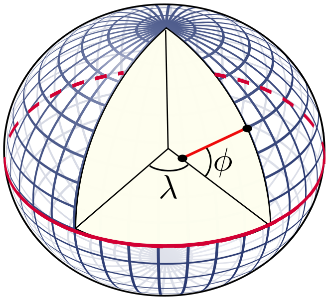
English: The definition of latitude (φ) and longitude (λ) on an ellipsoid of revolution (or spheroid). The graticule spacing is 10 degrees. The latitude is defined as the angle between the normal to the ellipsoid and the equatorial plane. |
| 日付 | |
| 原典 | 投稿者自身による著作物 |
| 作者 | Peter Mercator |
| その他のバージョン |
The graticule was taken from the file Sphere wireframe 10deg 10r.svg. このファイルの派生元: Sphere wireframe 10deg 10r.svg |
| SVG 開発 |
ライセンス
[編集]
| この著作物の著作権者である私は、この著作物における権利を放棄しパブリックドメインとします。これは全世界で適用されます。 一部の国では、これが法的に可能ではない場合があります。その場合は、次のように宣言します。 私は、あらゆる人に対して、法により必要とされている条件を除き、如何なる条件も課すことなく、あらゆる目的のためにこの著作物を使用する権利を与えます。 |
ファイルの履歴
過去の版のファイルを表示するには、その版の日時をクリックしてください。
| 日付と時刻 | サムネイル | 寸法 | 利用者 | コメント | |
|---|---|---|---|---|---|
| 現在の版 | 2010年12月5日 (日) 21:20 | | 825 × 750 (102キロバイト) | Peter Mercator (トーク | 投稿記録) | {{Information |Description={{en|1=The definition of latitude and longitude on an ellipsoid of revolution (or spheroid). The graticule spacing is 10 degrees. The latitude is defined as the angle between the normal to the ellipsoid and the equatorial plane. |
このファイルは上書きできません。
ファイルの使用状況
このファイルを使用しているページはありません。
グローバルなファイル使用状況
以下に挙げる他のウィキがこの画像を使っています:
- bg.wikipedia.org での使用状況
- ca.wikipedia.org での使用状況
- cs.wikipedia.org での使用状況
- de.wikipedia.org での使用状況
- en.wikipedia.org での使用状況
- Cartography
- Geodesy
- Latitude
- Navigation
- Geophysics
- Geoid
- Very-long-baseline interferometry
- Remote sensing
- Geomatics
- Photogrammetry
- Earth's orbit
- Geodetic astronomy
- Virtual globe
- Category:Geodesists
- Gravity of Earth
- Computer cartography
- Inertial navigation system
- User:Peter Mercator/Draft figures
- Template:Portal/doc/all
- Portal:Geophysics
- Geopositioning
- List of geodesists
- Template:Geodesy navbox
- Portal:Geodesy
- User:Certes/Reports/Portals
- ja.wikipedia.org での使用状況
- ja.wikibooks.org での使用状況
- ko.wikipedia.org での使用状況
- nl.wikipedia.org での使用状況
- sl.wikipedia.org での使用状況
- ta.wikipedia.org での使用状況
- tum.wikipedia.org での使用状況
- zh.wikipedia.org での使用状況