File:Lille 1922 orig.jpg
Jump to navigation
Jump to search

Size of this preview: 427 × 599 pixels. Other resolutions: 171 × 240 pixels | 342 × 480 pixels | 548 × 768 pixels | 730 × 1,024 pixels | 1,461 × 2,048 pixels | 5,006 × 7,019 pixels.
Original file (5,006 × 7,019 pixels, file size: 7.04 MB, MIME type: image/jpeg)
Captions
Captions
Add a one-line explanation of what this file represents
Summary
[edit]
| Description |
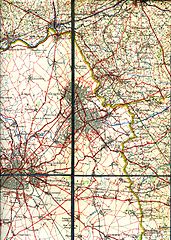
English: The region around Lille and the Belgian border in 1922. This shows the railways and trams around that time. This military staff map was cut up and pasted on a canvas.
Railway lines are black lines with marks on one side. Smalltrack is a thinner line. If there are marks on both sides it is double track. Nederlands: De streek rond Rijsel met spoor- en tramwegen van 1922. Deze kaart is uitgesneden en geplakt op een canvas. |
| Date | (scanned 2010) |
| Source | Belgian militairy staf map (IV. Tournai) |
| Author | L'Institut Cartographique Militaire (Belgian army) |
| Other versions | Derivative works of this file: Lille 1922 afgeleide small.jpg |
Licensing
[edit]
|
This work is in the public domain in its country of origin and other countries and areas where the copyright term is the author's life plus 70 years or fewer. | |
| This file has been identified as being free of known restrictions under copyright law, including all related and neighboring rights. | |
This work is in the public domain in the United States because it was published (or registered with the U.S. Copyright Office) before January 1, 1929.
Public domain works must be out of copyright in both the United States and in the source country of the work in order to be hosted on the Commons. If the work is not a U.S. work, the file must have an additional copyright tag indicating the copyright status in the source country.
Note: This tag should not be used for sound recordings. |
File history
Click on a date/time to view the file as it appeared at that time.
| Date/Time | Thumbnail | Dimensions | User | Comment | |
|---|---|---|---|---|---|
| current | 21:11, 6 June 2010 | | 5,006 × 7,019 (7.04 MB) | Smiley.toerist (talk | contribs) | {{Information |Description={{en|1=The region around Lille and the Belgian border in 1922. This shows the railways and trams around that time. This militairy staf map was cut upp and pasted on a canvas.}} {{nl|1=De streek rond Rijsel met spoor- en tramwege |
You cannot overwrite this file.
File usage on Commons
The following page uses this file: