File:Lincolnshire UK locator map 2010.svg
Spring til navigation
Spring til søgning

Size of this PNG preview of this SVG file: 494 × 600 pixels. Andre opløsninger: 198 × 240 pixels | 395 × 480 pixels | 633 × 768 pixels | 843 × 1.024 pixels | 1.687 × 2.048 pixels | 1.108 × 1.345 pixels.
Oprindelig fil (SVG fil, basisstørrelse 1.108 × 1.345 pixels, filstørrelse: 302 KB)
Captions
Captions
Tilføj en kort forklaring på en enkelt linje om hvad filen viser
Beskrivelse
[redigér]
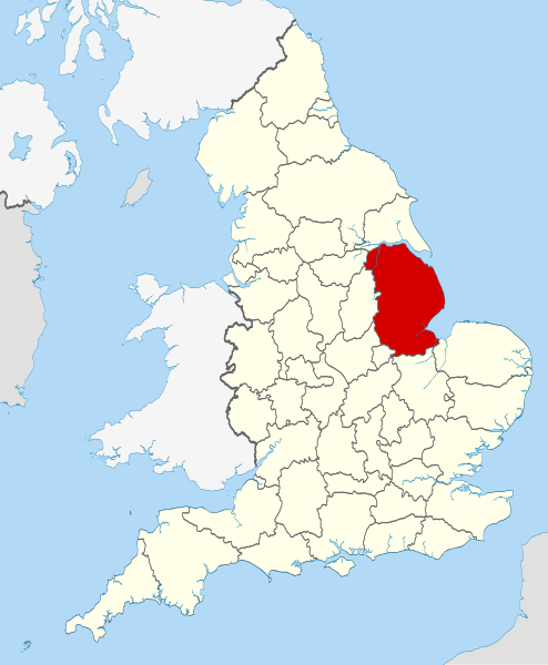
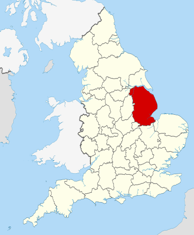
| Beskrivelse | Location of the ceremonial county of Lincolnshire within England. |
| Dato | |
| Kilde |
National Geospatial-Intelligence Agency
|
| Forfatter | Nilfanion |
Licensering
[redigér]
Jeg, dette værks ophavsretsindehaver, udgiver hermed værket under den følgende licens:
Denne fil er udgivet under Creative Commons Kreditering-Del på samme vilkår 3.0 Ikke-porteret-licensen.
- Du må frit:
- at dele – at kopiere, distribuere og overføre værket
- at remixe – at tilpasse værket
- Under følgende vilkår:
- kreditering – Du skal give passende kreditering, angive et link til licensen, og oplyse om der er foretaget ændringer. Du må gøre det på enhver fornuftig måde, men ikke på en måde der antyder at licensgiveren godkender dig eller din anvendelse.
- deling på samme vilkår – Hvis du bearbejder, ændrer eller bygger videre på dette værk, skal du distribuere dine bidrag under den samme eller en kompatibel licens som originalen.

|
Tilladelse er givet til at kopiere, distribuere og/eller ændre dette dokument under betingelserne i GNU Free Documentation License', Version 1.2 eller enhver senere version udgivet af Free Software Foundation; uden et invariant afsnit, ingen forsidetekster, og ingen bagsidetekst. En kopi af licensen er inkluderet i afsnittet GNU Free Documentation License. |
Du kan vælge den licens du foretrækker.

|
This is one of the images forming part of the Valued image set: Locator maps of the Ceremonial counties of England on Wikimedia Commons. The image set has been assessed under the valued image set criteria and is considered the most valued set on Commons within the scope:
Locator maps of the Ceremonial counties of England
You can see its nomination at Commons:Valued image candidates/Locator maps of English ceremonial counties. |
Filhistorik
Klik på en dato/tid for at se filen som den så ud på det tidspunkt.
| Dato/tid | Miniaturebillede | Dimensioner | Bruger | Kommentar | |
|---|---|---|---|---|---|
| nuværende | 23. nov. 2010, 22:40 | | 1.108 × 1.345 (302 KB) | Nilfanion (diskussion | bidrag) | == Summary == {{Information |Description=Location of the ceremonial county of Lincolnshire within England. |Source=Ordnance Survey [https://www.ordnancesurvey.co.uk/opendatadownload/products.html OpenData]: *County |
Du kan ikke overskrive denne fil.
Filanvendelse
De følgende 29 sider bruger denne fil:
- Valued image set: Locator maps of the Ceremonial counties of England
- Commons:Valued image candidates/Locator maps of English ceremonial counties
- Category:Alumni by school in Lincolnshire
- Category:Archaeological sites in Lincolnshire
- Category:Bridges in Lincolnshire
- Category:Canals in Lincolnshire
- Category:Cemeteries in Lincolnshire
- Category:Hospitals in Lincolnshire
- Category:Lincolnshire
- Category:Lincolnshire in the 17th century
- Category:Lincolnshire in the 1970s
- Category:Lincolnshire in the 1980s
- Category:Lincolnshire in the 1990s
- Category:Lincolnshire in the 19th century
- Category:Lincolnshire in the 2010s
- Category:Lincolnshire in the 20th century
- Category:Lincolnshire in the 21st century
- Category:Maps of Lincolnshire
- Category:People of Lincolnshire
- Category:Populated places in Lincolnshire
- Category:Rail transport in Lincolnshire
- Category:Rivers of Lincolnshire
- Category:Roads in Lincolnshire
- Category:Towers in Lincolnshire
- Category:Tunnels in Lincolnshire
- Category:Views of Lincolnshire
- Category:Villages in Lincolnshire
- Category:Visitor attractions in Lincolnshire
- Category:Windmills in Lincolnshire
Global filanvendelse
Følgende andre wikier anvender denne fil:
- Anvendelser på af.wikipedia.org
- Anvendelser på ar.wikipedia.org
- Anvendelser på arz.wikipedia.org
- Anvendelser på ast.wikipedia.org
- Anvendelser på be-tarask.wikipedia.org
- Anvendelser på bg.wikipedia.org
- Anvendelser på ca.wikipedia.org
- Anvendelser på ceb.wikipedia.org
- Anvendelser på cs.wikipedia.org
- Anvendelser på en.wikipedia.org
- Lincolnshire
- Scopwick
- Thornton Abbey
- South Ormsby
- Borough of Cleethorpes
- Boothby Graffoe
- Burton, Lincolnshire
- New York, Lincolnshire
- North Ings Farm Museum
- Jurassic Way
- Temple Bruer Preceptory
- Weelsby Woods
- Haverholme Priory
- Appleby, Lincolnshire
- Brampton, Lincolnshire
- Eagle, Lincolnshire
- Linwood, Lincolnshire
- Martin, North Kesteven
- Marton, Lincolnshire
- Upton, Lincolnshire
- Westborough, Lincolnshire
- Westville, Lincolnshire
- Apley
- Asgarby, North Kesteven
- Asgarby, East Lindsey
- Ashby by Partney
- Thompson's Bottom
- Vaudey Abbey
- Aswardby
- Kates Bridge
- Withcall
- List of parliamentary constituencies in Lincolnshire
- Template:Lincolnshire-geo-stub
- Frieston
- Hilldyke, Lincolnshire
- Bourne Abbey
- Skirbeck Wapentake
- Bottesford Preceptory
- Aslackby Preceptory
- Lincolnshire Marsh
Vis flere globale anvendelser af denne fil.