File:Livingston-Island-Overview-Map-EN.tif
Jump to navigation
Jump to search

Size of this JPG preview of this TIF file: 800 × 522 pixels. Other resolutions: 320 × 209 pixels | 640 × 417 pixels | 1,024 × 668 pixels | 1,280 × 834 pixels | 2,560 × 1,669 pixels | 6,096 × 3,974 pixels.
Original file (6,096 × 3,974 pixels, file size: 69.31 MB, MIME type: image/tiff)
Captions
Captions
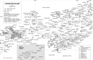
Overview map of Livingston Island, Antarctica
Summary[edit]
| Description |
English: Overview map of Livingston Island, Antarctica published in: L. Ivanov and N. Ivanova. The World of Antarctica. Generis Publishing, 2022. 241 pp. ISBN 979-8-88676-403-1 |
| Date | |
| Source | Own work |
| Author | Apcbg |
Author Lyubomir Ivanov alias Apcbg
Licensing[edit]
I, the copyright holder of this work, hereby publish it under the following license:
This file is licensed under the Creative Commons Attribution-Share Alike 4.0 International license.
- You are free:
- to share – to copy, distribute and transmit the work
- to remix – to adapt the work
- Under the following conditions:
- attribution – You must give appropriate credit, provide a link to the license, and indicate if changes were made. You may do so in any reasonable manner, but not in any way that suggests the licensor endorses you or your use.
- share alike – If you remix, transform, or build upon the material, you must distribute your contributions under the same or compatible license as the original.
File history
Click on a date/time to view the file as it appeared at that time.
| Date/Time | Thumbnail | Dimensions | User | Comment | |
|---|---|---|---|---|---|
| current | 18:38, 17 September 2022 |  | 6,096 × 3,974 (69.31 MB) | Apcbg (talk | contribs) | typo fix |
| 17:21, 4 July 2022 |  | 6,096 × 3,974 (69.31 MB) | Apcbg (talk | contribs) | Uploaded own work with UploadWizard |
You cannot overwrite this file.
File usage on Commons
There are no pages that use this file.
File usage on other wikis
The following other wikis use this file:
- Usage on en.wikipedia.org