File:Lloyd's official map of the State of Virginia from actual surveys by order of the Executive, 1828 & 1859 LOC 99448887.jpg
Jump to navigation
Jump to search

Size of this preview: 800 × 539 pixels. Other resolutions: 320 × 215 pixels | 640 × 431 pixels | 1,024 × 690 pixels | 1,280 × 862 pixels | 2,560 × 1,724 pixels | 14,275 × 9,612 pixels.
Original file (14,275 × 9,612 pixels, file size: 30.35 MB, MIME type: image/jpeg)
Captions
Captions
Add a one-line explanation of what this file represents
Summary
[edit]| Warning | The original file is very high-resolution. It might not load properly or could cause your browser to freeze when opened at full size. |
|---|
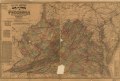
| Description |
English: Scale ca. 1:650,000. LC Civil War Maps (2nd ed.), 481.2 Includes a testimonial from William A. Bryan, Chief Clerk, Post Office Department, dated February 10, 1863. 1861 editions are listed as entry nos. 450 and 450.1 and the 1862 editions as 465 and 465.1. Some of the city and town names highlighted in red. Description derived from published bibliography. Available also through the Library of Congress web site as raster image. |
||
| Title | Lloyd's official map of the State of Virginia from actual surveys by order of the Executive, 1828 & 1859 | ||
| Shelf ID | G3880 1863 .L42 | ||
| Date | |||
| Source | https://www.loc.gov/item/99448887/ | ||
| Author | Lloyd, James T. | ||
| Permission (Reusing this file) |
|
||
| Other versions |
|
||
| Location | United States · Maryland · Delaware · Virginia | ||
| Part of | Military Battles And Campaigns · American Memory · Civil War Maps · Catalog · Geography And Map Division | ||
| Subject | United States · Maps · Maryland · Delaware · Virginia |

Licensing
[edit]
|
This is a faithful photographic reproduction of a two-dimensional, public domain work of art. The work of art itself is in the public domain for the following reason:
The official position taken by the Wikimedia Foundation is that "faithful reproductions of two-dimensional public domain works of art are public domain".
This photographic reproduction is therefore also considered to be in the public domain in the United States. In other jurisdictions, re-use of this content may be restricted; see Reuse of PD-Art photographs for details. | ||||
File history
Click on a date/time to view the file as it appeared at that time.
| Date/Time | Thumbnail | Dimensions | User | Comment | |
|---|---|---|---|---|---|
| current | 12:24, 31 May 2018 | | 14,275 × 9,612 (30.35 MB) | Fæ (talk | contribs) | LOC Maps https://www.loc.gov/item/99448887/ #818 |
You cannot overwrite this file.
File usage on Commons
The following page uses this file: