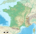
File:Location of Musilac.png
From Wikimedia Commons, the free media repository
Jump to navigation
Jump to search
Location_of_Musilac.png (253 × 240 pixels, file size: 128 KB, MIME type: image/png)
File information
Structured data
Captions
Captions
Add a one-line explanation of what this file represents
| DescriptionLocation of Musilac.png |
English: A map of france and the location of Musilac |
| Source | http://fr.wikipedia.org/wiki/Fichier:France_relief_location_map.jpg |
| Author | Eric Gaba |
| Permission (Reusing this file) |
visible on the source page |

|
Permission is granted to copy, distribute and/or modify this document under the terms of the GNU Free Documentation License, Version 1.2 or any later version published by the Free Software Foundation; with no Invariant Sections, no Front-Cover Texts, and no Back-Cover Texts. A copy of the license is included in the section entitled GNU Free Documentation License.http://www.gnu.org/copyleft/fdl.htmlGFDLGNU Free Documentation Licensetruetrue |
If this file is eligible for relicensing, it may also be used under the Creative Commons Attribution-ShareAlike 3.0 license. The relicensing status of this image needs to be manually reviewed by an experienced user. You can help. العربيَّة | беларуская (тарашкевіца) | English | français | magyar | italiano | 日本語 | 한국어 | македонски | മലയാളം | sicilianu | українська | 中文 | +/− |
File history
Click on a date/time to view the file as it appeared at that time.
| Date/Time | Thumbnail | Dimensions | User | Comment | |
|---|---|---|---|---|---|
| current | 09:56, 24 October 2012 |  | 253 × 240 (128 KB) | LoukasFaivre (talk | contribs) | smaller picture |
| 09:49, 24 October 2012 |  | 563 × 539 (564 KB) | LoukasFaivre (talk | contribs) | {{subst:Upload marker added by en.wp UW}} {{Information |Description = {{en|A map of france and the location of Musilac}} |Source = http://fr.wikipedia.org/wiki/Fichier:France_relief_location_map.jpg |Author = Eric Gaba |Permission = visible on the sou... |
You cannot overwrite this file.
File usage on Commons
There are no pages that use this file.
