File:London Underground full map.svg
跳转到导航
跳转到搜索

此SVG文件的PNG预览的大小:800 × 467像素。 其他分辨率:320 × 187像素 | 640 × 373像素 | 1,024 × 597像素 | 1,280 × 747像素 | 2,560 × 1,493像素 | 6,000 × 3,500像素。
原始文件 (SVG文件,尺寸为6,000 × 3,500像素,文件大小:239 KB)
说明
说明
添加一行文字以描述该文件所表现的内容
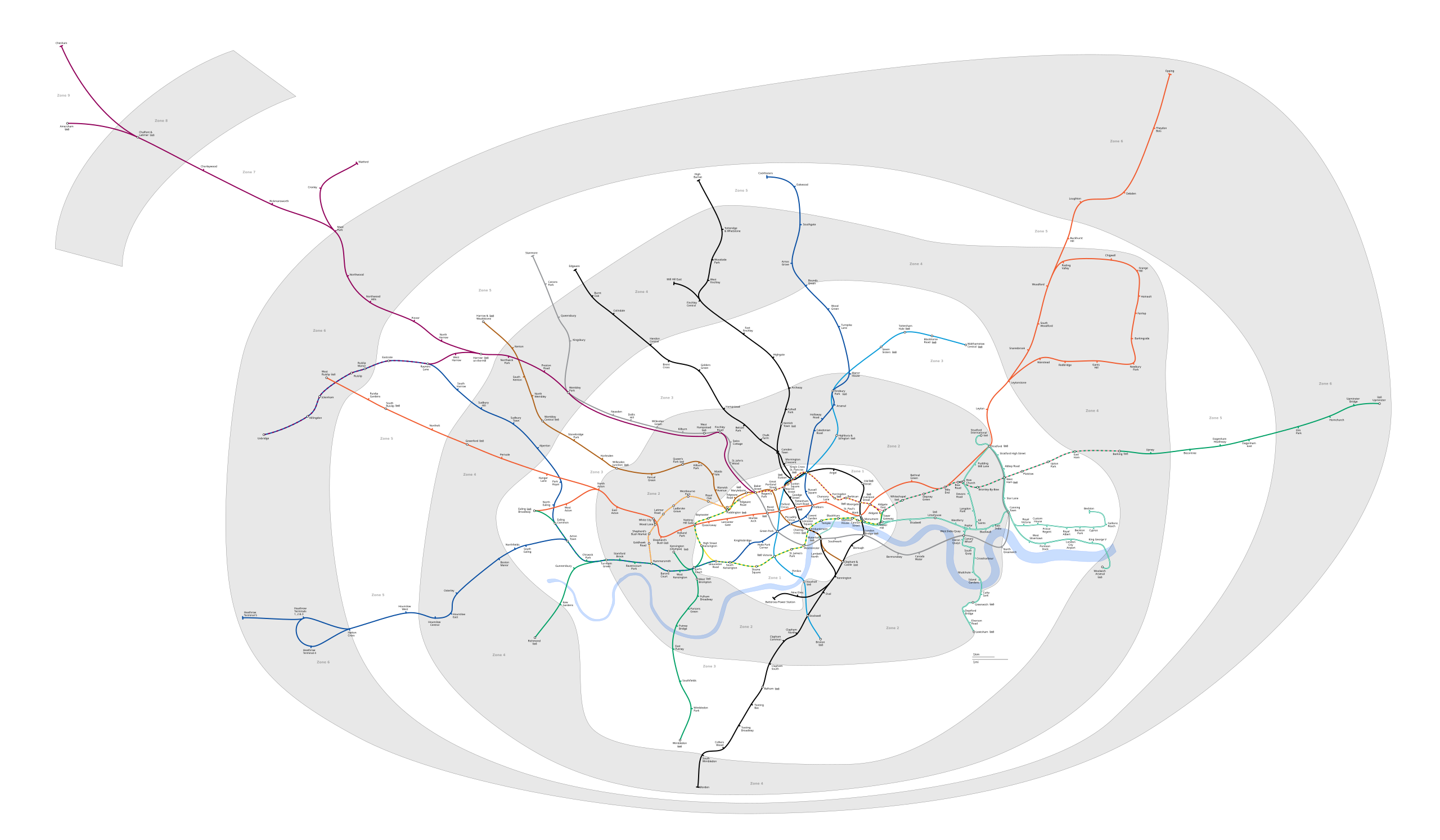
| 描述 | Geographic Map of the London Underground showing all stations with travelcard zones indicated | ||||||||
| 日期 | (UTC) | ||||||||
| 来源 | |||||||||
| 作者 |
|
||||||||
| 授权 (二次使用本文件) |
我,本作品著作权人,特此采用以下许可协议发表本作品:
您可以选择您需要的许可协议。 |
||||||||
| 其他版本 |
PNG version: File:London Underground full map.png File:SW Chinese Map of the London Underground.svg |

原始上传日志
[编辑]
This image is a derivative work of the following images:
- File:London_Underground_full_map.svg licensed with Cc-by-sa-2.5,2.0,1.0, GFDL
- 2009-05-31T00:05:06Z DavidCane 1000x570 (292205 Bytes) Stations added (in non visible section of map): Wood Lane, Woolwich Arsenal, Langdon Park. Station renamed: Shepherd' Bush to Shepherd's Bush Market
- 2009-04-07T12:50:10Z Ed g2s 1000x570 (287789 Bytes) remove external file references
- 2009-04-07T12:47:04Z Ed g2s 1000x570 (289202 Bytes) {{Information |Description={{en|1=London Underground map}} |Source=Own work by uploader |Author=[[User:Ed g2s|Ed g2s]] |Date= |Permission= |other_versions= }}
Uploaded with derivativeFX
文件历史
点击某个日期/时间查看对应时刻的文件。
| 日期/时间 | 缩略图 | 大小 | 用户 | 备注 | |
|---|---|---|---|---|---|
| 当前 | 2023年5月24日 (三) 17:50 | | 6,000 × 3,500(239 KB) | NordNordWest(留言 | 贡献) | corr |
| 2023年5月24日 (三) 17:34 |  | 6,000 × 3,500(239 KB) | NordNordWest(留言 | 贡献) | several updates | |
| 2020年7月20日 (一) 20:14 |  | 6,000 × 3,500(237 KB) | Hx7(留言 | 贡献) | Move Zone 3 text out of Zone 2 area in East London | |
| 2020年7月20日 (一) 13:02 |  | 6,000 × 3,500(237 KB) | Hx7(留言 | 贡献) | Boundary corrections - Woolwich Arsenal is in Zone 4, not Zone 3 | |
| 2018年2月4日 (日) 22:16 |  | 6,000 × 3,500(237 KB) | DavidCane(留言 | 贡献) | Alter zone 2 boundary to reflect the dual-zone status of DLR stations on the Stratford branch. | |
| 2014年8月12日 (二) 03:15 |  | 6,000 × 3,500(187 KB) | Jc86035(留言 | 贡献) | Added Stratford Intl extension from File:DOcklands Light Railway.svg, also added geographically accurate paths from that image, and linked together paths and set IDs | |
| 2014年8月8日 (五) 10:33 |  | 6,000 × 3,500(189 KB) | Jc86035(留言 | 贡献) | Fixed Edgware Road stations (now unlinked). Thanks to User:Sameboat for finding the error | |
| 2014年3月8日 (六) 03:36 |  | 6,000 × 3,500(186 KB) | Jc86035(留言 | 贡献) | Compressed using SVGCleaner | |
| 2013年12月3日 (二) 12:42 |  | 6,000 × 3,500(257 KB) | Jc86035(留言 | 贡献) | Better aligned Waterloo & City line | |
| 2013年12月3日 (二) 10:47 |  | 6,000 × 3,500(256 KB) | Jc86035(留言 | 贡献) | Fixed a large amount of issues; see London Underground geographic maps#To do |
您不可以覆盖此文件。
文件用途
以下15个页面使用本文件:
- User:Chumwa/OgreBot/Potential transport maps/2018 February 1-9
- User:Chumwa/OgreBot/Public transport information/2018 February 1-9
- User:Chumwa/OgreBot/Public transport information/2020 July 11-20
- User:Chumwa/OgreBot/Public transport information/2023 May 21-31
- User:Chumwa/OgreBot/Transport Maps/2018 February 1-9
- User:Chumwa/OgreBot/Transport Maps/2020 July 11-20
- User:Chumwa/OgreBot/Transport Maps/2023 May 21-31
- User:Chumwa/OgreBot/Travel and communication maps/2018 February 1-9
- User:Mattbuck/Railways/2018 February 1-9
- User:Mattbuck/Railways/2020 July
- User:Mattbuck/Railways/2023 May
- File:London Underground full map complete.svg(文件重定向)
- Category:London Underground
- Category:London Underground depots
- Category:London Underground lines
全域文件用途
以下其他wiki使用此文件:
- ar.wikipedia.org上的用途
- da.wikipedia.org上的用途
- de.wikipedia.org上的用途
- en.wikipedia.org上的用途
- et.wikipedia.org上的用途
- fr.wikipedia.org上的用途
- Métro de Londres
- Woodside Park (métro de Londres)
- High Barnet (métro de Londres)
- Totteridge & Whetstone (métro de Londres)
- Morden (métro de Londres)
- Burnt Oak (métro de Londres)
- West Finchley (métro de Londres)
- Brent Cross (métro de Londres)
- Golders Green (métro de Londres)
- Finchley Central (métro de Londres)
- Colliers Wood (métro de Londres)
- Stratford (métro de Londres)
- Mill Hill East (métro de Londres)
- Edgware (métro de Londres)
- Balham (métro de Londres)
- Barking (métro de Londres)
- Colindale (métro de Londres)
- Hendon Central (métro de Londres)
- Kilburn Park (métro de Londres)
- Willesden Junction (métro de Londres)
- Alperton (métro de Londres)
- Sudbury Town (métro de Londres)
- Wimbledon Park (métro de Londres)
- Becontree (métro de Londres)
- Upney (métro de Londres)
- Dagenham Heathway (métro de Londres)
- Dagenham East (métro de Londres)
- Canning Town (métro de Londres)
- Kilburn (métro de Londres)
- Willesden Green (métro de Londres)
- Dollis Hill (métro de Londres)
- Neasden (métro de Londres)
- Wembley Park (métro de Londres)
- Kingsbury (métro de Londres)
- Queensbury (métro de Londres)
- Northwick Park (métro de Londres)
- Preston Road (métro de Londres)
- East Finchley (métro de Londres)
查看此文件的更多全域用途。