File:Los Cabos, Mexico ESA23313914.tiff

Original file (10,015 × 7,746 pixels, file size: 222.06 MB, MIME type: image/tiff)
Captions
Captions
Summary[edit]
| Description |
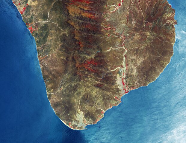
English: The Copernicus Sentinel-2 mission takes us over Los Cabos – a municipality on the southern tip of Mexico's Baja California Peninsula. Zoom in to see this image at its full 10 m resolution or click on the circles to learn more about the features in it. Meaning ‘the capes’ in Spanish, Los Cabos is a region composed of mountains and coastal plains and is largely dry and rocky with over 320 days of sunshine each year. The area encompasses the two cities of Cabo San Lucas (visible in the bottom-left) and San José del Cabo (visible to the right). The area along the coast between the two cities, often referred to as the Los Cabos Resort Corridor or simply the Corridor, stretches around 30 km along the highway and features a plethora of beaches dotted primarily with hotels, resorts and golf courses. The peninsula ends with the Arch of Cabo San Lucas, known locally as ‘El Arco’ or ‘Land’s End.’ This distinctive land formation, carved by winds and waves, is where the Pacific Ocean meets the Gulf of California, also known as the Sea of Cortez. The Arch of Cabo San Lucas is adjacent to Lovers Beach (Playa del Amor) on the Sea of Cortez side and Divorce Beach (Playa del Divorcio) on the rougher Pacific Ocean side. The arch is a popular gathering area for sea lions and is frequented by tourists. A region of mountains dominate the landscape including the Sierra de la Laguna Mountain Range and the Sierra de San Lázaro, which are both formed of volcanic rock with peaks between 400 and 1000 m. The main river in the area is the San José River, visible in the right of the image, and flows north to south primarily during the summer rainy season. The river creates an estuary at its southern end, which is one of the largest in Mexico and is home to both native and migratory birds. This image, which is also featured on the Earth from Space video programme, has been processed in a way that included the Copernicus Sentinel-2’s near-infrared channel, which makes vegetation appear bright red. As the image was acquired on 20 June 2020, the region is particularly dry with little vegetation visible. A comparison showing the high-density of vegetation in the area during the rainy season is available here. |
| Date | 21 May 2021 (upload date) |
| Source | Los Cabos, Mexico |
| Author | European Space Agency |
| Other versions |
|
| Activity | Observing the Earth |
| Mission | Sentinel-2 |
| Set | Earth observation image of the week |
| System | Copernicus |

Licensing[edit]

|
This image contains data from a satellite in the Copernicus Programme, such as Sentinel-1, Sentinel-2 or Sentinel-3. Attribution is required when using this image.
Attribution: Contains modified Copernicus Sentinel data 2020
The use of Copernicus Sentinel Data is regulated under EU law (Commission Delegated Regulation (EU) No 1159/2013 and Regulation (EU) No 377/2014). Relevant excerpts:
Free access shall be given to GMES dedicated data [...] made available through GMES dissemination platforms [...].
Access to GMES dedicated data [...] shall be given for the purpose of the following use in so far as it is lawful:
GMES dedicated data [...] may be used worldwide without limitations in time.
GMES dedicated data and GMES service information are provided to users without any express or implied warranty, including as regards quality and suitability for any purpose. |
This media was created by the European Space Agency (ESA).
Where expressly so stated, images or videos are covered by the Creative Commons Attribution-ShareAlike 3.0 IGO (CC BY-SA 3.0 IGO) licence, ESA being an Intergovernmental Organisation (IGO), as defined by the CC BY-SA 3.0 IGO licence. The user is allowed under the terms and conditions of the CC BY-SA 3.0 IGO license to Reproduce, Distribute and Publicly Perform the ESA images and videos released under CC BY-SA 3.0 IGO licence and the Adaptations thereof, without further explicit permission being necessary, for as long as the user complies with the conditions and restrictions set forth in the CC BY-SA 3.0 IGO licence, these including that:
See the ESA Creative Commons copyright notice for complete information, and this article for additional details.
|
 | |
This file is licensed under the Creative Commons Attribution-ShareAlike 3.0 IGO license. Attribution: ESA, CC BY-SA IGO 3.0
| ||
File history
Click on a date/time to view the file as it appeared at that time.
| Date/Time | Thumbnail | Dimensions | User | Comment | |
|---|---|---|---|---|---|
| current | 10:31, 21 May 2021 |  | 10,015 × 7,746 (222.06 MB) | OptimusPrimeBot (talk | contribs) | #Spacemedia - Upload of https://esamultimedia.esa.int/img/2021/05/Cabo_SLucas_S2B_20200620_842_mosaic_ML.tif via Commons:Spacemedia |
You cannot overwrite this file.
File usage on Commons
The following page uses this file: