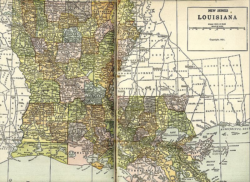
File:Louisiana1921Map.jpg
Salta a la navegació
Salta a la cerca

Mida d'aquesta previsualització: 800 × 581 píxels. Altres resolucions: 320 × 232 píxels | 640 × 465 píxels | 1.024 × 743 píxels | 1.171 × 850 píxels.
Fitxer original (1.171 × 850 píxels, mida del fitxer: 497 Ko, tipus MIME: image/jpeg)
Llegendes
Llegendes
Afegeix una explicació d'una línia del que representa aquest fitxer
Scanned from "New Pictorial Atlas of the World" by George Wharton James and Alan H. Burgoyne, 1921 John Thomas
This work is in the public domain in the United States because it was published (or registered with the U.S. Copyright Office) before January 1, 1929.
Public domain works must be out of copyright in both the United States and in the source country of the work in order to be hosted on the Commons. If the work is not a U.S. work, the file must have an additional copyright tag indicating the copyright status in the source country.
Note: This tag should not be used for sound recordings. |
Historial del fitxer
Cliqueu una data/hora per veure el fitxer tal com era aleshores.
| Data/hora | Miniatura | Dimensions | Usuari/a | Comentari | |
|---|---|---|---|---|---|
| actual | 01:14, 21 nov 2004 | | 1.171 × 850 (497 Ko) | Infrogmation (discussió | contribucions) | Map of Louisiana, 1921. PD-US |
No podeu sobreescriure aquest fitxer.
Ús del fitxer
La pàgina següent utilitza aquest fitxer:
Ús global del fitxer
Utilització d'aquest fitxer en altres wikis: