File:Luzon Strait n7184.jpg
Pumunta sa nabigasyon
Pumunta sa paghahanap

Laki ng pasilip na ito: 318 x 598 na pixel. Ibang resolusyon: 127 x 240 na pixel | 542 x 1,020 na pixel.
Orihinal na file (542 × 1,020 na pixel, laki: 77 KB, uri ng MIME: image/jpeg)
Captions
Captions
Add a one-line explanation of what this file represents
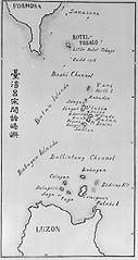
| Paglalarawan | Old map of the Luzon Strait (not labeled), including the Bashi Channel, between Orchid Island (Botel Tobago on the map) of Taiwan and the Batan Islands of the Philippines. Names may be out of date. Japanese caption: "Islands between Taiwan and Luzon". | |||||
| Petsa | Hindi alam na araw | |||||
| Pinanggalingan |
From digital archive of the University of Tokyo. [1] Cropped by a-giâu. |
|||||
| May-akda | anthropologist Torii Ryūzō (1870-1953) | |||||
| Permiso (Muling paggamit sa file) |
|


Nakaraan ng file
Pindutin ang isang petsa/oras para makita ang file noong puntong yon.
| Petsa/Oras | Thumbnail | Sukat | Tagagamit | Komento | |
|---|---|---|---|---|---|
| ngayon | 23:30, 11 Nobyembre 2004 | | 542 × 1,020 (77 KB) | A-giâu (usapan | ambag) | Old map of the Luzon Strait,(not labeled), including the Bashi Channel, between Orchid Island (Botel Tobago in the map) of Taiwan and the Batanes of the Philippines. Names may be out of date. From digital archive of the Universit |
Hindi mo mao-overwrite ang file na ito.
Paggamit sa file
Ginagamit ng sumusunod na 6 (na) pahina ang file na ito:
Pandaigdigang paggamit sa file
Ginagamit ng mga sumusunod na wiki ang file na ito:
- Paggamit sa ar.wikipedia.org
- Paggamit sa ast.wikipedia.org
- Paggamit sa az.wikipedia.org
- Paggamit sa bcl.wikipedia.org
- Paggamit sa be.wikipedia.org
- Paggamit sa ca.wikipedia.org
- Paggamit sa ceb.wikipedia.org
- Paggamit sa cs.wikipedia.org
- Paggamit sa da.wikipedia.org
- Paggamit sa de.wikipedia.org
- Paggamit sa en.wikipedia.org
- Paggamit sa es.wikipedia.org
- Paggamit sa eu.wikipedia.org
- Paggamit sa fa.wikipedia.org
- Paggamit sa fr.wikipedia.org
- Paggamit sa he.wikipedia.org
- Paggamit sa hi.wikipedia.org
- Paggamit sa id.wikipedia.org
- Paggamit sa ilo.wikipedia.org
- Paggamit sa it.wikipedia.org
- Paggamit sa ja.wikipedia.org
- Paggamit sa ko.wikipedia.org
- Paggamit sa lt.wikipedia.org
- Paggamit sa mk.wikipedia.org
- Paggamit sa nl.wikipedia.org
Tingnan ang karagdagang pandaigdigang paggamit sa file na ito.