File:Lyon. La Guillotière. Plan. 1702.JPG
Jump to navigation
Jump to search
Size of this preview: 800 × 595 pixels. Other resolutions: 320 × 238 pixels | 640 × 476 pixels | 961 × 715 pixels.
Original file (961 × 715 pixels, file size: 204 KB, MIME type: image/jpeg)
Captions
Captions
Add a one-line explanation of what this file represents
Summary[edit]
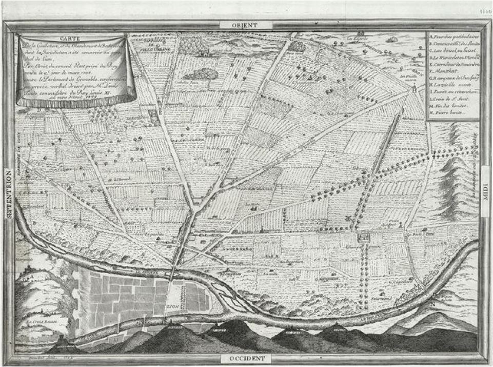
| Français : Pan d’un territoire. Des lettres, auxquelles se rapportent une légende portée dans la carte, permettent de saisir la limite de territoire. Dans le plan se trouvent de nombreuses annotations | |||||||||||
|---|---|---|---|---|---|---|---|---|---|---|---|
| Author |
Bouchet |
||||||||||
| Title |
Français : Pan d’un territoire. Des lettres, auxquelles se rapportent une légende portée dans la carte, permettent de saisir la limite de territoire. Dans le plan se trouvent de nombreuses annotations |
||||||||||
| Date | 1702 | ||||||||||
| Medium | reproduction: printing, original: engraving | ||||||||||
| Dimensions | original height: 29.5 cm (11.6 in); width: 40.5 cm (15.9 in) | ||||||||||
| Inscriptions |
recto on the paper, in the top right hand corner, out of the frame: 1702
Orient. Midi. Occident. Septentrion
recto in the top left hand corner: Carte de la Guillotière et du mandement de Béchevelin, dont la juridiction a été conservée au présidial de Lyon. Par arrêt du conseil d’État du Roi rendu le 9e jour de mars 1701. Contre le parlement de Grenoble conformément au procès-verbal dressé par Mr Louis Tindo commissaire du roi Louis XI, au mois d'août 1479 recto in the top right hand corner: A – Fourches patibulaires. B – Communauté des pénitents. C – Lac d’oisel ou Oisel . D – Le Moucherotte ou Moncelet. E – Carrefour de Symandre. F - Montchat. G – Rampeaux de Chaussagne. H – La vieille morte. I – Fossés ou retranchements. [J - . K - . non mentionnés] L – Croix de St Fond. M – Fin des limites. N – Pierre bénite |
||||||||||
| References | (1876) Le mandement de Béchevelin, ses limites et ses paroisses, accompagné de quatre planches et de figures (in 8), Lyon: A. Vingtrinier OCLC: 421962653. "planche III" | ||||||||||
| Source/Photographer | Own work | ||||||||||
| Permission (Reusing this file) |
|
||||||||||


File history
Click on a date/time to view the file as it appeared at that time.
| Date/Time | Thumbnail | Dimensions | User | Comment | |
|---|---|---|---|---|---|
| current | 00:14, 29 April 2016 | | 961 × 715 (204 KB) | 6PO (talk | contribs) | User created page with UploadWizard |
You cannot overwrite this file.
File usage on Commons
The following page uses this file:
File usage on other wikis
The following other wikis use this file:
- Usage on en.wikipedia.org
- Usage on fr.wikipedia.org