File:Límites marítimos de Venezuela.png
Jump to navigation
Jump to search
No higher resolution available.
Límites_marítimos_de_Venezuela.png (732 × 558 pixels, file size: 22 KB, MIME type: image/png)
Captions
Captions
Add a one-line explanation of what this file represents
Summary
[edit]
| Description |
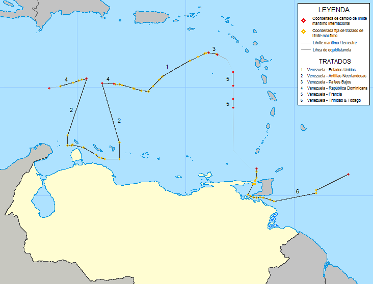
English: Map of maritime boundaries of Venezuela
Español: Mapa de los límites marinos de Venezuela
1:Tratado entre los Estados Unidos y Venezuela (28 de marzo de 1978) |
| Date | |
| Source | Own work |
| Author | Milenioscuro |
| Other versions | extracted from File:Mapa del Caribe (límites marinos).png |
.png)
Licensing
[edit]
I, the copyright holder of this work, hereby publish it under the following license:
This file is licensed under the Creative Commons Attribution-Share Alike 3.0 Unported license.
- You are free:
- to share – to copy, distribute and transmit the work
- to remix – to adapt the work
- Under the following conditions:
- attribution – You must give appropriate credit, provide a link to the license, and indicate if changes were made. You may do so in any reasonable manner, but not in any way that suggests the licensor endorses you or your use.
- share alike – If you remix, transform, or build upon the material, you must distribute your contributions under the same or compatible license as the original.
File history
Click on a date/time to view the file as it appeared at that time.
| Date/Time | Thumbnail | Dimensions | User | Comment | |
|---|---|---|---|---|---|
| current | 17:26, 11 April 2014 | | 732 × 558 (22 KB) | Milenioscuro (talk | contribs) | colores estandar / inclusion de leyenda |
| 21:12, 27 July 2011 |  | 651 × 468 (17 KB) | Milenioscuro (talk | contribs) | {{Information |Description ={{en|1=Map of maritime boundaries of Venezuela}} {{es|1=Mapa de los límites marinos de Venezuela}} |Source ={{own}} |Author =Shadowxfox |Date =2011 |Permission = |other_vers |
You cannot overwrite this file.
File usage on Commons
The following page uses this file:
File usage on other wikis
The following other wikis use this file:
- Usage on en.wikipedia.org
- Usage on es.wikipedia.org
- Usage on fr.wikipedia.org
Metadata
Categories:
- Maps of borders of Venezuela
- Maps of territorial waters of Venezuela
- Maps of borders of the United States
- Maps of borders of the Netherlands
- Maps of borders of the Dominican Republic
- Maps of borders of France
- Maps of borders of Trinidad and Tobago
- United States-Venezuela border
- France-Venezuela border
- Dominican Republic-Venezuela border
- Trinidad and Tobago-Venezuela border
- Netherlands-Venezuela border