File:München - Stadtbezirke (Karte).png
Original file (2,119 × 1,641 pixels, file size: 338 KB, MIME type: image/png)
Captions
Captions
Articles about the boroughs of Munich in the German Wikipedia (original list)
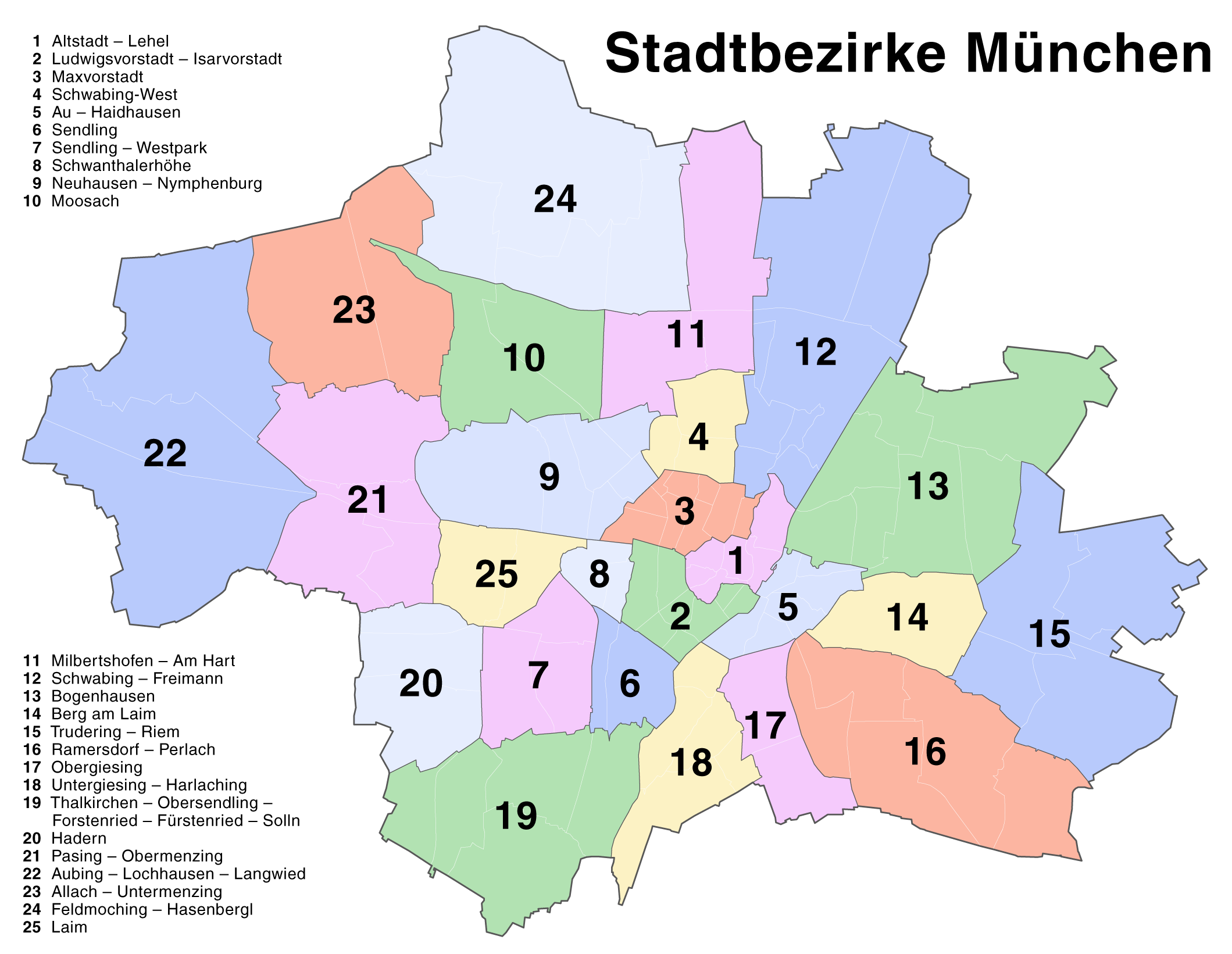
23 Allach-Untermenzing - 1 Altstadt-Lehel - 22 Aubing-Lochhausen-Langwied - 5 Au-Haidhausen - 14 Berg am Laim - 13 Bogenhausen - 24 Feldmoching-Hasenbergl - 20 Hadern - 25 Laim - 2 Ludwigsvorstadt-Isarvorstadt - 3 Maxvorstadt - 11 Milbertshofen-Am Hart - 10 Moosach - 9 Neuhausen-Nymphenburg - 17 Obergiesing - 21 Pasing-Obermenzing - 16 Ramersdorf-Perlach - 12 Schwabing-Freimann - 4 Schwabing-West - 8 Schwanthalerhöhe - 6 Sendling - 7 Sendling-Westpark - 19 Thalkirchen-Obersendling-Forstenried-Fürstenried-Solln - 15 Trudering-Riem - 18 Untergiesing-Harlaching
| Description |
Deutsch: Kartenserie der Münchner Stadtbezirke
English: Boroughs of Munich map series |
| Date | |
| Source | Self made, created with Adobe Illustrator 12.0 |
| Author | Maximilian Dörrbecker (Chumwa) |
| Permission (Reusing this file) |
This map was created by Maximilian Dörrbecker. Attribution to Wikipedia or another project of the Wikimedia foundation is required if it is used outside of projects of the Wikimedia foundation. This file is licensed under the Creative Commons Attribution-Share Alike 2.5 Generic license.
"I want to use the image. How do I do that?" You can use this map freely for any purpose, including commercial use, provided that you license it under the above license. My suggestion is to use the following text:
|
| Other versions |
Die Serie besteht aus den folgenden Karten / The series consists of the following maps : Region München:
Stadt München:
|


.png)


.png)
.png)


_-_Altstadt_-_Lehel.png)
_-_Ludwigsvorstadt_-_Isarvorstadt.png)
_-_Maxvorstadt.png)
_-_Schwabing-West.png)
_-_Au_-_Haidhausen.png)
_-_Sendling.png)
_-_Sendling_-_Westpark.png)
_-_Schwanthalerh%C3%B6he.png)
_-_Neuhausen_-_Nymphenburg.png)
_-_Moosach.png)
_-_Milbertshofen_-_Am_Hart.png)
_-_Bogenhausen.png)
_-_Berg_am_Laim.png)
_-_Trudering_-_Riem.png)
_-_Ramersdorf_-_Perlach.png)
_-_Obergiesing.png)
_-_Thalkirchen_-_Obersendling_-_Forstenried_-_F%C3%BCrstenried_-_Solln.png)
_-_Hadern.png)
_-_Pasing_-_Obermenzing.png)
_-_Aubing_-_Lochhausen_-_Langwied.png)
_-_Allach_-_Untermenzing.png)
_-_Feldmoching_-_Hasenbergl.png)
_-_Laim.png)
File history
Click on a date/time to view the file as it appeared at that time.
| Date/Time | Thumbnail | Dimensions | User | Comment | |
|---|---|---|---|---|---|
| current | 16:22, 20 August 2007 | | 2,119 × 1,641 (338 KB) | Chumwa (talk | contribs) | Correction of the district numbering in the named list (many thanks to Andreas for the error hint!) |
| 16:16, 18 August 2007 |  | 2,119 × 1,641 (342 KB) | Chumwa (talk | contribs) | {{Information |Description= *{{ de }} Kartenserie der Münchner Stadtbezirke *{{ en }} Boroughs of Munich map series |Source=Self made, created with Adobe Illustrator 12.0 |Date=August 2007 |Author=Maximilian Dörrbecker ([[:de:User:Ch |
You cannot overwrite this file.
File usage
The following 63 pages use this file:
- User:Chumwa
- User:Chumwa/Gallery
- User:Chumwa/OtherVersions - Karten München
- File:Administrative boundaries of the borough of Solln in Munich.png
- File:Basiskarte Kiel.png
- File:Karte Flaucher München.png
- File:Karte München - WirtshausWiesn 2020.png
- File:Karte München Basiskarte.jpg
- File:Karte München Basiskarte.png
- File:Karte München Landnutzung.png
- File:Karte München Schwarzplan.png
- File:Karte München ÖPNV.png
- File:Karte München Übersichtsplan.png
- File:Karte Streetlife München.png
- File:Karte Viktualienmarkt München.png
- File:Karte der Burgfrieden von München.png
- File:Karte der Denkmalschutzensembles in München.jpg
- File:Karte der Gemarkungen in München.png
- File:Karte der Gemarkungen und Stadtbezirke in München.png
- File:Karte der Ortsbezeichnungen in München.png
- File:Karte der Parkstadt Bogenhausen in München.png
- File:Karte der Stadtbezirke in München.png
- File:Karte der Stadtbezirke in München in der bis 1992 gültigen Gliederung.png
- File:Karte der Stadtbezirksteile in München.png
- File:München - Basiskarte farbig.pdf
- File:München - Basiskarte farbig.png
- File:München - Basiskarte farbig - mit Nachbargemeinden.jpg
- File:München - Basiskarte farbig - mit Nachbargemeinden.png
- File:München - Basiskarte grau.pdf
- File:München - Basiskarte grau.png
- File:München - Stadtbezirk 01 (Karte) - Altstadt - Lehel.png
- File:München - Stadtbezirk 02 (Karte) - Ludwigsvorstadt - Isarvorstadt.png
- File:München - Stadtbezirk 03 (Karte) - Maxvorstadt.png
- File:München - Stadtbezirk 04 (Karte) - Schwabing-West.png
- File:München - Stadtbezirk 05 (Karte) - Au - Haidhausen.png
- File:München - Stadtbezirk 06 (Karte) - Sendling.png
- File:München - Stadtbezirk 07 (Karte) - Sendling - Westpark.png
- File:München - Stadtbezirk 08 (Karte) - Schwanthalerhöhe.png
- File:München - Stadtbezirk 09 (Karte) - Neuhausen - Nymphenburg.png
- File:München - Stadtbezirk 10 (Karte) - Moosach.png
- File:München - Stadtbezirk 11 (Karte) - Milbertshofen - Am Hart.png
- File:München - Stadtbezirk 12 (Karte) - Schwabing - Freimann.png
- File:München - Stadtbezirk 13 (Karte) - Bogenhausen.png
- File:München - Stadtbezirk 14 (Karte) - Berg am Laim.png
- File:München - Stadtbezirk 15 (Karte) - Trudering - Riem.png
- File:München - Stadtbezirk 16 (Karte) - Ramersdorf - Perlach.png
- File:München - Stadtbezirk 17 (Karte) - Obergiesing.png
- File:München - Stadtbezirk 18 (Karte) - Untergiesing - Harlaching.png
- File:München - Stadtbezirk 19 (Karte) - Thalkirchen - Obersendling - Forstenried - Fürstenried - Solln.png
- File:München - Stadtbezirk 20 (Karte) - Hadern.png
- File:München - Stadtbezirk 21 (Karte) - Pasing - Obermenzing.png
- File:München - Stadtbezirk 22 (Karte) - Aubing - Lochhausen - Langwied.png
- File:München - Stadtbezirk 22 (Karte) - Aubing - Lochhausen - Langwied (nach Stadtteilen).png
- File:München - Stadtbezirk 23 (Karte) - Allach - Untermenzing.png
- File:München - Stadtbezirk 24 (Karte) - Feldmoching - Hasenbergl.png
- File:München - Stadtbezirk 25 (Karte) - Laim.png
- File:München - Stadtbezirke (Karte).png
- File:München - Stadtbezirke (Karte) - V2.png
- File:München - Stadtbezirke und Stadtbezirksteile (Karte).svg
- File:Positionskarte München.png
- File:Stadterweiterungen München.png
- File:Westpark München (Karte).png
- File:Westpark München zur IGA 1983 (Karte).png
_-_Schwabing_-_Freimann.png)
_-_Untergiesing_-_Harlaching.png)
_-_Aubing_-_Lochhausen_-_Langwied_(nach_Stadtteilen).png)
_-_V2.png)
.svg)
Global file usage
The following other wikis use this file:
- Usage on ba.wikipedia.org
- Usage on bxr.wikipedia.org
- Usage on de.wikipedia.org
- Usage on en.wikipedia.org
- Usage on fr.wikipedia.org
- Usage on kk.wikipedia.org
- Usage on lez.wikipedia.org
- Usage on pl.wikivoyage.org
- Usage on ru.wikipedia.org
- Usage on vep.wikipedia.org
.png&oldid=453312727)