File:MOLA Map.png
Jump to navigation
Jump to search

Size of this preview: 800 × 316 pixels. Other resolutions: 320 × 126 pixels | 640 × 253 pixels | 1,024 × 405 pixels | 1,280 × 506 pixels | 3,294 × 1,302 pixels.
Original file (3,294 × 1,302 pixels, file size: 6.94 MB, MIME type: image/png)
Captions
Captions
Add a one-line explanation of what this file represents
Summary[edit]
| Description |
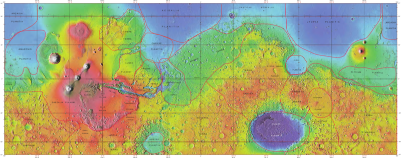
English: Topographical map generated from MOLA data including feature boundaries. Acidalia Planitia is the central, northernmost feature characterized by dark blue, low elevation land. |
| Date | |
| Source | https://planetarynames.wr.usgs.gov/images/mola_regional_boundaries.pdf |
| Author | United States Geological Survey |
Licensing[edit]
This image is in the public domain in the United States because it only contains materials that originally came from the United States Geological Survey, an agency of the United States Department of the Interior. For more information, see the official USGS copyright policy.
|
File history
Click on a date/time to view the file as it appeared at that time.
| Date/Time | Thumbnail | Dimensions | User | Comment | |
|---|---|---|---|---|---|
| current | 15:37, 11 December 2018 | 3,294 × 1,302 (6.94 MB) | LazyAssed Contender (talk | contribs) | same source, better resolution | |
| 20:48, 14 April 2017 | 675 × 262 (440 KB) | Geochem8 (talk | contribs) | User created page with UploadWizard |
You cannot overwrite this file.
File usage on Commons
The following page uses this file:
File usage on other wikis
The following other wikis use this file:
- Usage on en.wikipedia.org