File:Magalhães Elcano Circum-navegação-pt.svg
Jump to navigation
Jump to search

Size of this PNG preview of this SVG file: 749 × 380 pixels. Other resolutions: 320 × 162 pixels | 640 × 325 pixels | 1,024 × 520 pixels | 1,280 × 649 pixels | 2,560 × 1,299 pixels.
Original file (SVG file, nominally 749 × 380 pixels, file size: 112 KB)
Captions
Captions
Add a one-line explanation of what this file represents
| Description |
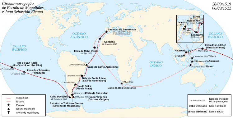
English: Map of the first world circumnavigation of Ferdinand de Magellan and Juan Sebastián Elcano, from 1519 to 1522. Français : Carte de la première circumnavigation autour du monde, par Ferdinand de Magellan et Juan Sebastián Elcano, de 1519 à 1522. |
| Date | (UTC) |
| Source | |
| Author |
|
| This is a retouched picture, which means that it has been digitally altered from its original version. Modifications: Portuguese translation. The original can be viewed here: Magellan Elcano Circumnavigation-fr.svg:
|
I, the copyright holder of this work, hereby publish it under the following licenses:
This file is licensed under the Creative Commons Attribution-Share Alike 3.0 Unported, 2.5 Generic, 2.0 Generic and 1.0 Generic license.
- You are free:
- to share – to copy, distribute and transmit the work
- to remix – to adapt the work
- Under the following conditions:
- attribution – You must give appropriate credit, provide a link to the license, and indicate if changes were made. You may do so in any reasonable manner, but not in any way that suggests the licensor endorses you or your use.
- share alike – If you remix, transform, or build upon the material, you must distribute your contributions under the same or compatible license as the original.

|
Permission is granted to copy, distribute and/or modify this document under the terms of the GNU Free Documentation License, Version 1.2 or any later version published by the Free Software Foundation; with no Invariant Sections, no Front-Cover Texts, and no Back-Cover Texts. A copy of the license is included in the section entitled GNU Free Documentation License. |
You may select the license of your choice.
Original upload log
[edit]
This image is a derivative work of the following images:
- File:Magellan_Elcano_Circumnavigation-fr.svg licensed with Cc-by-sa-3.0,2.5,2.0,1.0, GFDL
- 2008-03-02T15:16:17Z Sémhur 2246x1139 (224858 Bytes) Correction d'un texte
- 2008-03-01T16:18:00Z Sémhur 2246x1139 (224612 Bytes) {{Information |Description= {{en|French map of the first world [[:en:Circumnavigation|circumnavigation]] of [[:en:Ferdinand de Magellan|Ferdinand de Magellan]] and [[:en:Juan Sebastián Elcano|Juan Sebastián Elcano]], from 1
Uploaded with derivativeFX
File history
Click on a date/time to view the file as it appeared at that time.
| Date/Time | Thumbnail | Dimensions | User | Comment | |
|---|---|---|---|---|---|
| current | 04:14, 12 July 2022 | | 749 × 380 (112 KB) | Juniorpetjua (talk | contribs) | Ajustes |
| 04:12, 12 July 2022 |  | 749 × 380 (112 KB) | Juniorpetjua (talk | contribs) | Ajustes | |
| 04:07, 12 July 2022 |  | 749 × 380 (112 KB) | Juniorpetjua (talk | contribs) | Cabo de Santo Agostinho - Ajuste | |
| 04:03, 12 July 2022 |  | 749 × 380 (112 KB) | Juniorpetjua (talk | contribs) | Cabo de Santo Agostinho | |
| 03:54, 12 July 2022 |  | 749 × 380 (112 KB) | Juniorpetjua (talk | contribs) | Cabo de Santo Agostinho | |
| 12:04, 11 November 2013 |  | 749 × 380 (93 KB) | OAlexander~commonswiki (talk | contribs) | Add. fundo branco. | |
| 11:06, 11 November 2013 |  | 749 × 380 (93 KB) | OAlexander~commonswiki (talk | contribs) | Dado "Canárias" 1522 => 1519. Remoção "Juan Sebastián Elcano" no direito. Otimização geral. | |
| 12:08, 15 November 2009 |  | 2,246 × 1,139 (220 KB) | Uxbona (talk | contribs) | {{Information |Description={{en|French map of the first world circumnavigation of Ferdinand de Magellan and Juan Sebastián Elcano, from 1519 to 1522.}} {{fr|Carte de la |
You cannot overwrite this file.
File usage on Commons
The following 4 pages use this file:
File usage on other wikis
The following other wikis use this file:
- Usage on fr.wikiversity.org
- Usage on la.wikipedia.org
- Usage on mwl.wikipedia.org
- Usage on pt.wikipedia.org
- Usage on pt.wikibooks.org