File:Mali map.png
Pumunta sa nabigasyon
Pumunta sa paghahanap
Wala na'ng mas malinaw.
Mali_map.png (350 × 376 na pixel, laki: 11 KB, uri ng MIME: image/png)
Captions
Captions
Add a one-line explanation of what this file represents

|
This locator map image could be re-created using vector graphics as an SVG file. This has several advantages; see Commons:Media for cleanup for more information. If an SVG form of this image is available, please upload it and afterwards replace this template with
{{vector version available|new image name}}.
It is recommended to name the SVG file “Mali map.svg”—then the template Vector version available (or Vva) does not need the new image name parameter. |
Buod
[baguhin]
| Paglalarawan |
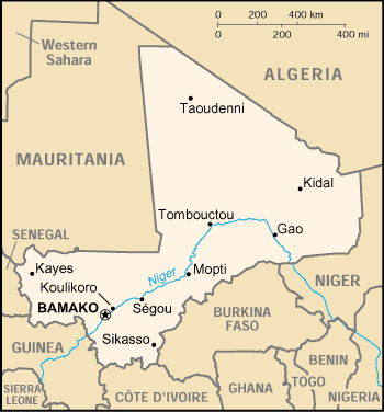
English: Map of Mali |
| Petsa | |
| Pinanggalingan | https://www.cia.gov/library/publications/the-world-factbook/geos/ml.html |
| May-akda | CIA |
Paglilisensiya
[baguhin]
| This image is a work of a Central Intelligence Agency employee, taken or made as part of that person's official duties. As a Work of the United States Government, this image or media is in the public domain in the United States.
|

|
Nakaraan ng file
Pindutin ang isang petsa/oras para makita ang file noong puntong yon.
| Petsa/Oras | Thumbnail | Sukat | Tagagamit | Komento | |
|---|---|---|---|---|---|
| ngayon | 21:03, 3 Marso 2005 | | 350 × 376 (11 KB) | Alfio (usapan | ambag) | CIA map of Mali |
Hindi mo mao-overwrite ang file na ito.
Paggamit sa file
Ginagamit ng sumusunod na 6 (na) pahina ang file na ito:
- Atlas of Mali
- Maps of Mali
- Índice de países
- File:Mali-CIA WFB Map (2004).png (redirect ng file)
- File:Mali.gif (redirect ng file)
- File:Ml-map.png (redirect ng file)
.png&redirect=no)
Pandaigdigang paggamit sa file
Ginagamit ng mga sumusunod na wiki ang file na ito:
- Paggamit sa als.wikipedia.org
- Paggamit sa am.wikipedia.org
- Paggamit sa ast.wikipedia.org
- Paggamit sa ban.wikipedia.org
- Paggamit sa bjn.wikipedia.org
- Paggamit sa ca.wikipedia.org
- Paggamit sa ceb.wikipedia.org
- Paggamit sa da.wikipedia.org
- Paggamit sa de.wikivoyage.org
- Paggamit sa en.wikipedia.org
- Paggamit sa es.wikipedia.org
- Paggamit sa eu.wikipedia.org
- Paggamit sa fa.wikipedia.org
- Paggamit sa fi.wikipedia.org
- Paggamit sa fo.wikipedia.org
- Paggamit sa fr.wikipedia.org
- Paggamit sa he.wikipedia.org
- Paggamit sa hi.wiktionary.org
- Paggamit sa hu.wikipedia.org
- Paggamit sa hu.wiktionary.org
- Paggamit sa id.wikipedia.org
- Paggamit sa io.wikipedia.org
- Paggamit sa ja.wikipedia.org
- Paggamit sa jv.wikipedia.org
- Paggamit sa ko.wikipedia.org
- Paggamit sa mr.wikipedia.org
- Paggamit sa nds.wikipedia.org
- Paggamit sa nl.wikipedia.org
- Paggamit sa no.wikipedia.org
- Paggamit sa oc.wikipedia.org
- Paggamit sa pl.wikipedia.org
- Paggamit sa pt.wikipedia.org
- Paggamit sa ro.wikipedia.org
Tingnan ang karagdagang pandaigdigang paggamit sa file na ito.