File:Maneuvers prior to the battle of Poitiers 1356 map-en.svg
Jump to navigation
Jump to search

Size of this PNG preview of this SVG file: 450 × 550 pixels. Other resolutions: 196 × 240 pixels | 393 × 480 pixels | 628 × 768 pixels | 838 × 1,024 pixels | 1,676 × 2,048 pixels.
Original file (SVG file, nominally 450 × 550 pixels, file size: 42 KB)
Captions
Captions
Add a one-line explanation of what this file represents
Summary
[edit]| Description |
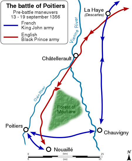
English: Maneuvers prior to the en:Battle of Poitiers (1356). Français : Carte montrant le chassé-croisé entre le Prince noir Edouard de Woodstock et le roi de France Jean II, avant la fr:bataille de Poitiers (1356). |
||
| Date | (UTC) | ||
| Source |
Own work. Source :
|
||
| Author | Sémhur (talk) | ||
| Other versions | |||
| Attribution (required by the license) | © Sémhur / Wikimedia Commons / | ||
| SVG | W3C-validity not checked.
|
||
| Graphic Lab |

| Camera location | | View this and other nearby images on: OpenStreetMap |
|---|
Licensing
[edit]
I, the copyright holder of this work, hereby publish it under the following licenses:
| Copyleft: This work of art is free; you can redistribute it and/or modify it according to terms of the Free Art License. You will find a specimen of this license on the Copyleft Attitude site as well as on other sites. |
This file is licensed under the Creative Commons Attribution-Share Alike Attribution-Share Alike 4.0 International, 3.0 Unported, 2.5 Generic, 2.0 Generic and 1.0 Generic license.
- You are free:
- to share – to copy, distribute and transmit the work
- to remix – to adapt the work
- Under the following conditions:
- attribution – You must give appropriate credit, provide a link to the license, and indicate if changes were made. You may do so in any reasonable manner, but not in any way that suggests the licensor endorses you or your use.
- share alike – If you remix, transform, or build upon the material, you must distribute your contributions under the same or compatible license as the original.
You may select the license of your choice.
Original upload log
[edit]
This image is a derivative work of the following images:
- File:Battle_poitiers_maneuvering.gif licensed with Cc-pd-mark-footer, PD-USGov
- 2007-12-28T21:39:01Z File Upload Bot (Magnus Manske) 571x703 (29601 Bytes) {{BotMoveToCommons|en.wikipedia}} {{Information |Description={{en|Pre-battle maneuvers prior to the [[:en:Battle of Poitiers (1356)]]. Created by the Department of History, United States Military Academy, West Point. Just
Uploaded with derivativeFX
File history
Click on a date/time to view the file as it appeared at that time.
| Date/Time | Thumbnail | Dimensions | User | Comment | |
|---|---|---|---|---|---|
| current | 08:11, 9 December 2016 | | 450 × 550 (42 KB) | Sémhur (talk | contribs) | Clain River, not Gartempe |
| 13:27, 27 May 2014 |  | 450 × 550 (37 KB) | Sémhur (talk | contribs) | Valid SVG | |
| 17:57, 11 November 2011 |  | 450 × 550 (37 KB) | Sémhur (talk | contribs) | == {{int:filedesc}} == {{Information |Description={{Multilingual description |en= Maneuvers prior to the en:Battle of Poitiers (1356). |fr= Carte montrant le chassé-croisé entre le Prince noir Edouard de Woodstock et le roi de France Jean II, avant |
You cannot overwrite this file.
File usage on Commons
The following page uses this file:
File usage on other wikis
The following other wikis use this file:
- Usage on ja.wikipedia.org
- Usage on ko.wikipedia.org
- Usage on sr.wikipedia.org
- Usage on uk.wikipedia.org
- Usage on zh.wikipedia.org