File:Mannerheim studying a map.jpg
Skočit na navigaci
Skočit na vyhledávání
Větší rozlišení není k dispozici.
Mannerheim_studying_a_map.jpg (300 × 232 pixelů, velikost souboru: 17 KB, MIME typ: image/jpeg)
Popisky
Popisky
Přidejte jednořádkové vysvětlení, co tento soubor představuje
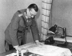
Marshal of Finland Carl Gustaf Emil Mannerheim studyding a map.
| Popis |
English: Marshal of Finland Carl Gustaf Emil Mannerheim studyding a map. Suomi: Marsalkka Carl Gustaf Emil Mannerheim tutkimassa karttaa. |
| Zdroj | http://www.mil.fi/paaesikunta/paaesikunta/historia/sota.dsp |
This photograph is in the public domain in Finland, because either a period of 50 years has elapsed from the year of creation or the photograph was first published before 1966. The section 49a of the Finnish Copyright Act (404/1961, amended 607/2015) specifies that photographs not considered to be "works of art" become public domain 50 years after they were created. The 50 years from creation protection period came into force in 1991. Before that the protection period was 25 years from the year of first publication according to the §16 of the law of protection of photographs of 1961. Material already released to public domain according to the 1961 law remains in public domain, and therefore all photographs (but not photographic works of art) released before 1966 are in the public domain. See Commons:Copyright rules by territory/Finland for details.
If you think this picture should be considered a work of art, nominate it for deletion. To uploader: Please provide where the image was first published and who created it. The material with this copyright tag should not be used on the German-language Wikipedia. See Talk page of this template.
|
Historie souboru
Kliknutím na datum a čas se zobrazí tehdejší verze souboru.
| Datum a čas | Náhled | Rozměry | Uživatel | Komentář | |
|---|---|---|---|---|---|
| současná | 28. 3. 2015, 11:53 | | 300 × 232 (17 KB) | Hohum (diskuse | příspěvky) | Greyscale |
| 23. 10. 2005, 18:37 |  | 300 × 232 (12 KB) | Hautala (diskuse | příspěvky) | Marshal of Finland Carl Gustav Emil Mannerheim studyding a map. Image downloaded from [http://www.mil.fi/paaesikunta/paaesikunta/historia/sota.dsp]. |
Tento soubor nemůžete přepsat.
Využití souboru
Na Commons na soubor odkazují tyto stránky:
Globální využití souboru
Tento soubor využívají následující wiki:
- Využití na ast.wikipedia.org
- Využití na az.wikipedia.org
- Využití na ca.wikipedia.org
- Využití na cs.wikipedia.org
- Využití na da.wikipedia.org
- Využití na eo.wikipedia.org
- Využití na es.wikipedia.org
- Využití na fi.wikipedia.org
- Využití na he.wikipedia.org
- Využití na hr.wikipedia.org
- Využití na ja.wikipedia.org
- Využití na ko.wikipedia.org
- Využití na no.wikipedia.org
- Využití na ru.wikipedia.org
- Využití na sv.wikipedia.org
- Využití na th.wikipedia.org
- Využití na tr.wikipedia.org
- Využití na uk.wikipedia.org