File:Map Bulgaria Septemvri–Dobrinishte narrow-gauge line.svg
Jump to navigation
Jump to search

Size of this PNG preview of this SVG file: 745 × 599 pixels. Other resolutions: 298 × 240 pixels | 597 × 480 pixels | 955 × 768 pixels | 1,273 × 1,024 pixels | 2,546 × 2,048 pixels | 2,486 × 2,000 pixels.
Original file (SVG file, nominally 2,486 × 2,000 pixels, file size: 3.06 MB)
Captions
Captions
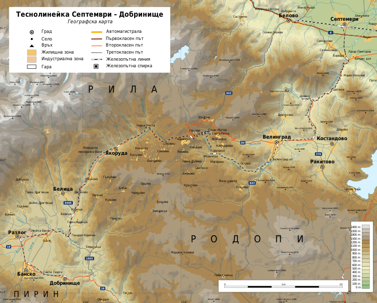
Map of Septemvri–Dobrinishte narrow-gauge line in Bulgaria
Summary[edit]
| Description |
English: Map of Septemvri–Dobrinishte narrow-gauge line in Bulgaria (in Bulgarian) Български: Карта на теснолинейката Септември – Добринище в България (на български) |
| Date | |
| Source |
Own work
|
| Author | Ikonact |
| Permission (Reusing this file) |
Any use of this map is subject of the license(s) stated below with the condition that you credit (Wikimedia Commons user: Ikonact) as the author . A message with a reply address would also be greatly appreciated. |
| SVG development |
Licensing[edit]
I, the copyright holder of this work, hereby publish it under the following license:
This file is licensed under the Creative Commons Attribution-Share Alike 4.0 International license.
- You are free:
- to share – to copy, distribute and transmit the work
- to remix – to adapt the work
- Under the following conditions:
- attribution – You must give appropriate credit, provide a link to the license, and indicate if changes were made. You may do so in any reasonable manner, but not in any way that suggests the licensor endorses you or your use.
- share alike – If you remix, transform, or build upon the material, you must distribute your contributions under the same or compatible license as the original.
File history
Click on a date/time to view the file as it appeared at that time.
| Date/Time | Thumbnail | Dimensions | User | Comment | |
|---|---|---|---|---|---|
| current | 21:34, 12 May 2021 | | 2,486 × 2,000 (3.06 MB) | Ikonact (talk | contribs) | valid svg |
| 20:26, 18 December 2020 |  | 2,486 × 2,000 (3.24 MB) | Ikonact (talk | contribs) | update | |
| 19:45, 6 April 2019 |  | 2,486 × 2,000 (3.24 MB) | Ikonact (talk | contribs) | some optimisation, + raod signs | |
| 19:32, 4 April 2019 |  | 2,486 × 2,000 (3.25 MB) | Ikonact (talk | contribs) | few more names + road numbers | |
| 20:37, 3 April 2019 |  | 2,486 × 2,000 (3.23 MB) | Ikonact (talk | contribs) | User created page with UploadWizard |
You cannot overwrite this file.
File usage on Commons
The following page uses this file:
File usage on other wikis
The following other wikis use this file:
- Usage on bg.wikipedia.org
- Usage on ru.wikipedia.org
- Usage on www.wikidata.org