File:Map Byzantine Empire 1045.svg

Oprindelig fil (SVG fil, basisstørrelse 1.300 × 900 pixels, filstørrelse: 428 KB)
Captions
Captions
Beskrivelse
[redigér]| Beskrivelse |
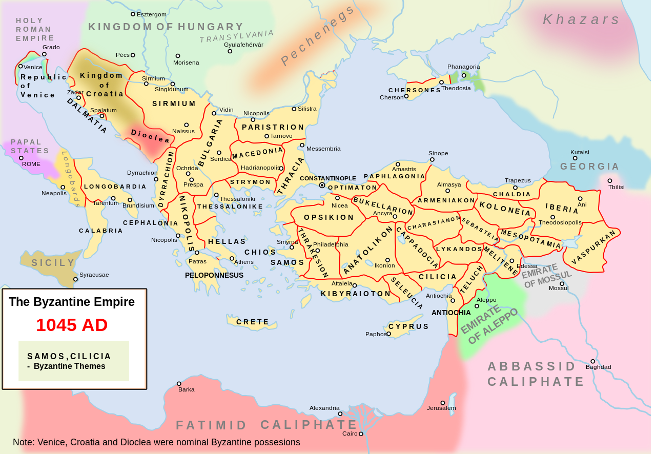
Català: L'imperi bizantí i els seus veïns l'any 1045. Inclou divisions administratives bizantines.
English: Own work. The Byzantine empire and its neighbours in 1045. Byzantine administrative divisions included.
Source> Stelian Brezeanu> O istorie a Imperiului Bizantin, Bucharest 1981. The map at page 110. Please write on the talk page if I misspelled the name of some themes. An available derivative work is a cropping showing only the central Balkans: :Image:Byzantine Macedonia 1045CE.svg. |
| Dato | 10. december 2007 (original upload date) |
| Kilde | Eget arbejde |
| Forfatter | Andrein at engelsk Wikipedia |
| Andre versioner |
File:Map Byzantine Empire 1045.svg has 2 translations.
Other related versions: []
|


|
SVG-filen indeholder indlejret tekst som let kan oversættes til dit sprog ved hjælp af [toolforge:svgtranslate/File:Map_Byzantine_Empire_1045.svglink dette automatiske værktøj]. Lær mere her. |
This file is translated using SVG For most Wikipedia projects, you can embed the file normally (without a To translate the text into your language, you can use the SVG Translate tool. Alternatively, you can download the file to your computer, add your translations using whatever software you're familiar with, and re-upload it with the same name. You will find help in Graphics Lab if you're not sure how to do this. |
Licensering
[redigér]
| Dette værk er blevet udgivet som offentlig ejendom af dets skaber, Andrein at engelsk Wikipedia. Dette gælder i hele verden. I nogle lande er dette ikke juridisk muligt. I så fald: Andrein giver enhver ret til at anvende dette værk til ethvert formål, uden nogen restriktioner, medmindre sådanne restriktioner er påkrævede ved lov. |
Filhistorik
Klik på en dato/tid for at se filen som den så ud på det tidspunkt.
| Dato/tid | Miniaturebillede | Dimensioner | Bruger | Kommentar | |
|---|---|---|---|---|---|
| nuværende | 11. feb. 2024, 16:06 | | 1.300 × 900 (428 KB) | Manlleus (diskussion | bidrag) | File uploaded using svgtranslate tool (https://svgtranslate.toolforge.org/). Added translation for ca. |
| 10. feb. 2024, 11:06 |  | 1.300 × 900 (428 KB) | Leptictidium (diskussion | bidrag) | File uploaded using svgtranslate tool (https://svgtranslate.toolforge.org/). Added translation for ca. | |
| 10. feb. 2024, 11:01 |  | 1.300 × 900 (428 KB) | Leptictidium (diskussion | bidrag) | File uploaded using svgtranslate tool (https://svgtranslate.toolforge.org/). Added translation for ca. | |
| 10. feb. 2024, 08:03 |  | 1.300 × 900 (428 KB) | Leptictidium (diskussion | bidrag) | File uploaded using svgtranslate tool (https://svgtranslate.toolforge.org/). Added translation for ca. | |
| 9. feb. 2024, 21:24 |  | 1.300 × 900 (428 KB) | Manlleus (diskussion | bidrag) | minor corrections to catalan translation | |
| 9. feb. 2024, 21:16 |  | 1.300 × 900 (428 KB) | Manlleus (diskussion | bidrag) | added catalan language | |
| 25. feb. 2019, 01:44 |  | 1.300 × 900 (335 KB) | Georgiano (diskussion | bidrag) | fixed borders, names. | |
| 29. sep. 2016, 07:33 |  | 1.300 × 900 (331 KB) | ArdadN (diskussion | bidrag) | some corrections | |
| 13. mar. 2016, 12:40 |  | 1.300 × 900 (337 KB) | Georgiano (diskussion | bidrag) | Theodosioupolis (now Erzurum, Turkey) was capital of theme of Iberia | |
| 29. jan. 2012, 18:40 |  | 1.300 × 900 (339 KB) | BotMultichillT (diskussion | bidrag) | {{BotMoveToCommons|en.wikipedia|year={{subst:CURRENTYEAR}}|month={{subst:CURRENTMONTHNAME}}|day={{subst:CURRENTDAY}}}} == {{int:filedesc}} == {{Information |description={{en|1=Own work. The Byzantine empire and its neighbours in 1045. Byzantine administr |
Du kan ikke overskrive denne fil.
Filanvendelse
De følgende 12 sider bruger denne fil:
- User:J budissin/Uploads/BiH/2016 March 11-20
- User:J budissin/Uploads/BiH/2016 September 21-30
- User:J budissin/Uploads/BiH/2019 February 19-28
- User:Jaqeli/Georgia
- User:Magog the Ogre/Multilingual legend/2024 February 10-14
- File:Map Byzantine Empire 1045-es.svg
- File:Map Byzantine Empire 1045-pt.svg
- File:Map Byzantine Empire 1045-zh.svg
- File:Map Byzantine Empire 1045.svg
- File:Map Byzantine Empire 1045 el.svg
- File:Mappa Impero bizantino 1045.svg
- Template:Other versions/Map Byzantine Empire 1045
Global filanvendelse
Følgende andre wikier anvender denne fil:
- Anvendelser på azb.wikipedia.org
- Anvendelser på ca.wikipedia.org
- Anvendelser på de.wikipedia.org
- Anvendelser på en.wikipedia.org
- Theme (Byzantine district)
- Byzantine–Georgian wars
- Talk:Narentines/Archive 2
- Kingdom of Georgia
- User talk:Iberieli
- File talk:Map Byzantine Empire 1045.svg
- User:Sasha l~enwiki/maps
- Wikipedia:Featured picture candidates/November-2008
- Wikipedia:Featured picture candidates/Byzantine Empire in 1045
- Talk:Byzantine Empire/Archive 10
- Timeline of Eastern Orthodoxy in Greece (717–1204)
- User:WildFields/sandbox
- User:Falcaorib/Medieval Empires (1000-1100 AD)
- Anvendelser på et.wikipedia.org
- Anvendelser på fr.wikipedia.org
- Anvendelser på it.wikipedia.org
- Anvendelser på ja.wikipedia.org
- Anvendelser på ka.wikipedia.org
- Anvendelser på ko.wikipedia.org
- Anvendelser på lt.wikipedia.org
- Anvendelser på mk.wikipedia.org
- Anvendelser på ru.wikipedia.org
- Anvendelser på sq.wikipedia.org
- Anvendelser på sr.wikipedia.org
- Anvendelser på tr.wikipedia.org
- Anvendelser på uk.wikipedia.org