File:Map Crusader states 1135-en.svg
Μετάβαση στην πλοήγηση
Πήδηση στην αναζήτηση

Το μέγεθος αυτής της PNG προεπισκόπησης αυτού του SVG το αρχείο: 435 × 599 εικονοστοιχεία. Άλλες αναλύσεις: 174 × 240 εικονοστοιχεία | 348 × 480 εικονοστοιχεία | 558 × 768 εικονοστοιχεία | 744 × 1.024 εικονοστοιχεία | 1.487 × 2.048 εικονοστοιχεία | 955 × 1.315 εικονοστοιχεία.
Πρωτότυπο αρχείο (Αρχείο SVG, ονομαστικό μέγεθος 955 × 1.315 εικονοστοιχεία, μέγεθος αρχείου: 418 KB)
Λεζάντες
Λεζάντες
Δεν ορίστηκε λεζάντα
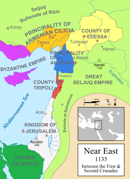
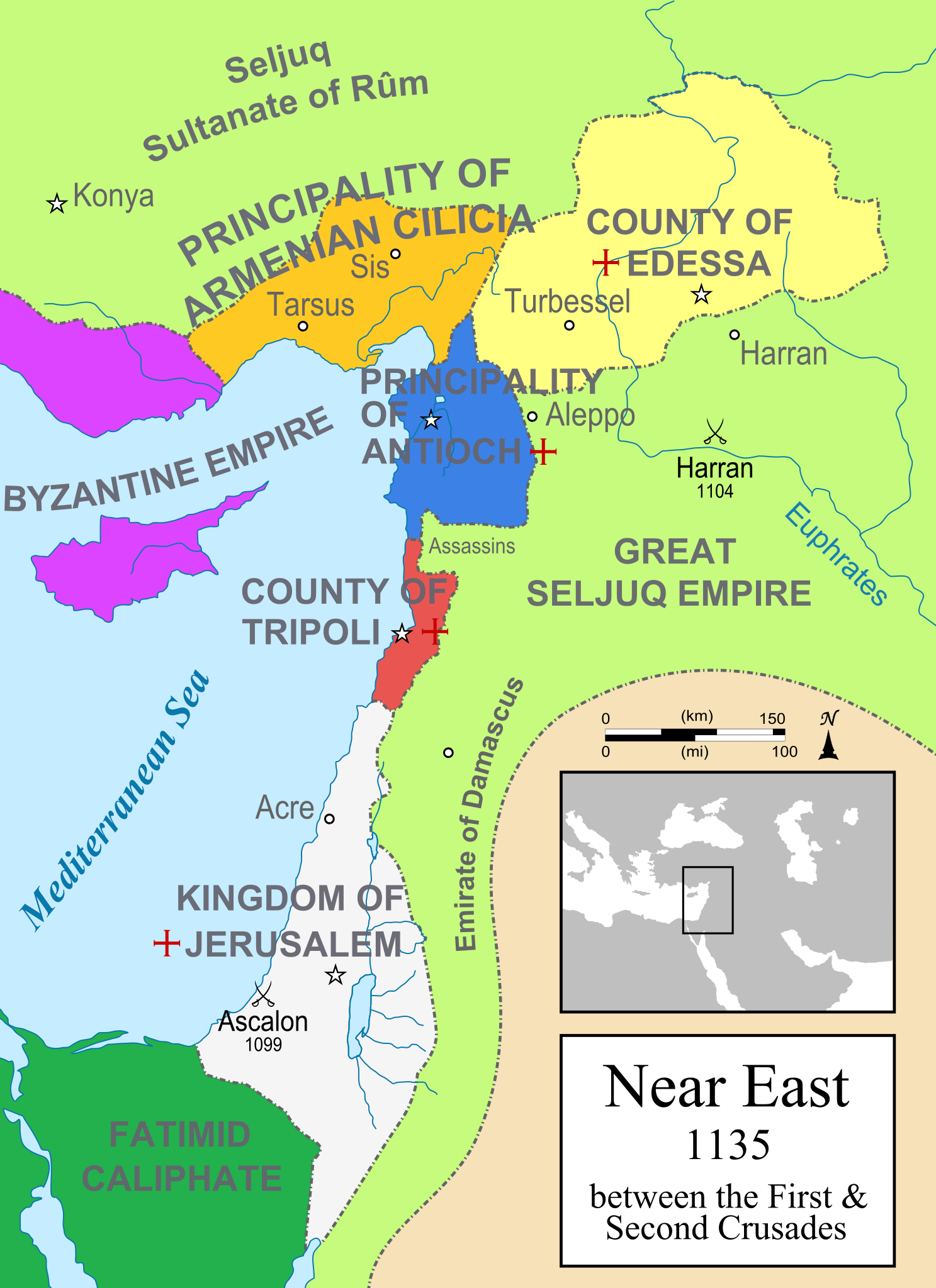
A political map of the Near East in 1135 CE. Crusader states are marked with a red cross.
Σύνοψη[επεξεργασία]
| Περιγραφή |
[]
Čeština: Politická mapa Blízkého východu v roce 1135. Deutsch: Die Levante, 1135, zwischen den Ersten und Zweiten Kreuzzügen. Kreuzzugsstaaten sind mit einem roten Kreuz gekennzeichnet Eesti: Lähis-Ida (1135) Español: Oriente Próximo en 1135, entre la primera y segunda cruzadas. Esperanto: Politika mapo de Levantenio dum 1135, inter la krucmilitaroj unuaj kaj duaj. Français : Carte politique du Proche-Orient en 1135, entre la Première et la Seconde Croisades. les États latins d'Orient sont marqués d'une croix rouge. Italiano: Carta politica del Vicino Oriente nel 1135. Magyar: A Közel-Kelet térképe 1135-ben. Polski: Mapa polityczna Bliskiego Wschodu w roku 1135, w okresie II krucjaty. Ελληνικά: Πολιτικός χάρτης της Μέσης Ανατολής το 1135, ανάμεσα στην πρώτη και τη δεύτερη Σταυροφορία Македонски: Политичка карта на Блискиот Исток во 1135 г. Крстоносните држави се означени со црвени крстови. Русский: Карта Ближнего Востока в 1135 г. Српски / srpski: Politička karta Bliskog Istoka 1135. godine, između Prvog i Drugog krstaškog pohoda. Krstaške države su označene crvenim krstom. ქართული: ახლო აღმოსავლეთი 1135 წელს ไทย: แผนที่ตะวันออกกลาง (คศ. 1135) ระหว่างครูเสดครั้งที่ 1 และครั่งที่ 2 中文: 一副关于1135年近东地区局势的地图,标注红色十字的为十字军国家 العربية : الدويلات الصليبية والدول الإسلامية المجاورة لها في الفترة بين الحملتين الصليبيتين الأولى والثانية. فارسی : نسخه فارسی |
||
| Πηγή | Έργο αυτού που το ανεβάζει | ||
| Δημιουργός | MapMaster | ||
| άλλες εκδόσεις |
[]
See also[επεξεργασία] |
||
| SVG ανάπτυξη |


-ka.png)


References[επεξεργασία]
- Bjorklund, Oddvar; Holmboe, Haakon; Rohr, Anders (1970) Historical Atlas of the World, Barnes & Noble, NY, SBN: 389-00253-4.
- Asia Minor and the Crusader states, c. 1140 from Findlay, Alexander G. (1849) Classical Atlas of Ancient Geography.
- Map of the Crusader states from Muir's Historical Atlas (1911)
Αδειοδότηση[επεξεργασία]
Εγώ, ο κάτοχος των πνευματικών δικαιωμάτων αυτού του έργου, το δημοσιεύω δια του παρόντος υπό την εξής άδεια χρήσης:

|
Παραχωρείται η άδεια προς αντιγραφή, διανομή και/ή τροποποίηση αυτού του εγγράφου υπό τους όρους της Άδειας Ελεύθερης Τεκμηρίωσης GNU, Έκδοση 1.2 ή οποιασδήποτε νεότερης έκδοσης δημοσιευμένης από το Ίδρυμα Ελεύθερου Λογισμικού· χωρίς Απαράλαχτους Τομείς, χωρίς Κείμενα Εξωφύλλου, και χωρίς Κείμενα Οπισθοφύλλου. Αντίγραφο της άδειας περιλαμβάνεται στην σελίδα με τίτλο GNU Free Documentation License. |
| Το αρχείο διανέμεται υπό την άδεια Creative Commons Αναφορά προέλευσης-Παρόμοια διανομή 3.0 Μη εισαγόμενη | ||
| ||
| Αυτή η ετικέτα άδειας χρήσης προστέθηκε στο αρχείο ως μέρους της αναθεώρησης της άδειας GFDL . |
derivative works[επεξεργασία]
Derivative works of this file:
Ιστορικό αρχείου
Πατήστε σε μια ημερομηνία/ώρα για να δείτε το αρχείο όπως εμφανιζόταν εκείνη την χρονική στιγμή.
| Ημερομηνία/Ώρα | Μικρογραφία | Διαστάσεις | Χρήστης | Σχόλιο | |
|---|---|---|---|---|---|
| τρέχον | 21:01, 19 Μαρτίου 2015 | | 955 × 1.315 (418 KB) | Denniss (συζήτηση | Συνεισφορά) | Reverted to version as of 09:13, 25 July 2012 |
| 13:03, 19 Μαρτίου 2015 |  | 955 × 1.315 (433 KB) | Dorudgar (συζήτηση | Συνεισφορά) | Translation from English to Arabic الترجمة من الإنگليزية إلى العربية | |
| 09:13, 25 Ιουλίου 2012 |  | 955 × 1.315 (418 KB) | HorsefaCe (συζήτηση | Συνεισφορά) | Cilicia wan't a kingdom yet | |
| 09:08, 25 Ιουλίου 2012 |  | 955 × 1.315 (120 KB) | HorsefaCe (συζήτηση | Συνεισφορά) | A Chinese version. | |
| 11:48, 12 Ιουλίου 2010 |  | 955 × 1.315 (418 KB) | Malus Catulus (συζήτηση | Συνεισφορά) | Cilicia wan't a kingdom yet | |
| 10:59, 12 Ιουλίου 2010 |  | 955 × 1.315 (424 KB) | Malus Catulus (συζήτηση | Συνεισφορά) | Corrected burid dynasty | |
| 22:01, 11 Ιουλίου 2010 |  | 955 × 1.315 (418 KB) | Malus Catulus (συζήτηση | Συνεισφορά) | Final tweaks | |
| 21:52, 11 Ιουλίου 2010 |  | 955 × 1.315 (403 KB) | Malus Catulus (συζήτηση | Συνεισφορά) | Now complies with w3c so I hope the box is gone | |
| 21:22, 11 Ιουλίου 2010 |  | 955 × 1.315 (403 KB) | Malus Catulus (συζήτηση | Συνεισφορά) | Trying to remove black box | |
| 21:18, 11 Ιουλίου 2010 |  | 955 × 1.315 (402 KB) | Malus Catulus (συζήτηση | Συνεισφορά) | Forgot to convert Med. sea and Euphrates to path |
Δεν μπορείτε να αντικαταστήσετε αυτό το αρχείο.
Χρήση αρχείου
Οι ακόλουθες 61 σελίδες χρησιμοποιούν προς αυτό το αρχείο:
- Atlas of Cyprus
- Atlas of Israel
- Atlas of Palestine
- Atlas of the Levant
- Levant
- User:Malus Catulus
- User:MapMaster
- File:CiliciaPrincipadoDeAntioquíaYCondadoDeTrípoli.svg
- File:Crusader States (1135)-ka.png
- File:Lähis-Ida 1135.png
- File:Map Crusader states 1135-ar.png
- File:Map Crusader states 1135-cs.svg
- File:Map Crusader states 1135-de.svg
- File:Map Crusader states 1135-de2.svg
- File:Map Crusader states 1135-el.svg
- File:Map Crusader states 1135-en.svg
- File:Map Crusader states 1135-eo.svg
- File:Map Crusader states 1135-es.svg
- File:Map Crusader states 1135-es2.svg
- File:Map Crusader states 1135-fr.svg
- File:Map Crusader states 1135-fr2.svg
- File:Map Crusader states 1135-hu.svg
- File:Map Crusader states 1135-hy.svg
- File:Map Crusader states 1135-it.png
- File:Map Crusader states 1135-jp.png
- File:Map Crusader states 1135-mk.svg
- File:Map Crusader states 1135-nl.svg
- File:Map Crusader states 1135-pl.png
- File:Map Crusader states 1135-pl.svg
- File:Map Crusader states 1135-pt.svg
- File:Map Crusader states 1135-ru.svg
- File:Map Crusader states 1135-zh.svg
- File:Map Crusads states 1135-fa.png
- File:MapofTripoli.png
- File:Near East 1135.svg (ανακατεύθυνση του αρχείου)
- User:MapMaster
- Atlas of Cyprus
- Atlas of Israel
- File:Principality of Antioch locator.svg
- Atlas of Palestine
- User:Malus Catulus
- File:Map Crusader states 1135-cs.svg
- File:Map Crusader states 1135-es2.svg
- File:Map Crusader states 1135-ar.png
- Levant
- File:Map Crusader states 1135-pt.svg
- File:Map Crusader states 1135-es.svg
- File:CiliciaPrincipadoDeAntioquíaYCondadoDeTrípoli.svg
- File:Map Crusader states 1135-hu.svg
- File:PrincipadodeAntioquía.png
- File:MapofTripoli.png
- File:PrincipadodeAntioquía.png
- File:Principality of Antioch locator.svg
- File:Second Crusade-ar.svg
- File:The Crusader States in 1135-ar.svg
- File:The Crusader States in 1135.svg
- Template:Other versions/Map Crusader states 1135
- Category:County of Tripoli
- Category:Kingdom of Jerusalem
- Category:Princes of Antioch
- Category:Principality of Antioch
Καθολική χρήση αρχείου
Τα ακόλουθα άλλα wiki χρησιμοποιούν αυτό το αρχείο:
- Χρήση σε an.wikipedia.org
- Χρήση σε ar.wikipedia.org
- Χρήση σε arz.wikipedia.org
- Χρήση σε ast.wikipedia.org
- Χρήση σε azb.wikipedia.org
- Χρήση σε az.wikipedia.org
- Χρήση σε ba.wikipedia.org
- Χρήση σε be.wikipedia.org
- Χρήση σε bg.wikipedia.org
- Χρήση σε bn.wikipedia.org
- Χρήση σε br.wikipedia.org
- Χρήση σε bxr.wikipedia.org
- Χρήση σε ckb.wikipedia.org
- Χρήση σε cs.wikipedia.org
- Χρήση σε cy.wikipedia.org
- Χρήση σε da.wikipedia.org
Δείτε περισσότερη καθολική χρήση αυτού του αρχείου.
Μεταδεδομένα
Κατηγορίες:
- Crusader states
- Maps of Cilicia
- Maps of the County of Edessa
- Maps of the County of Tripoli
- Maps of the Kingdom of Jerusalem
- Maps of the Principality of Antioch
- Maps of Crusader states
- Maps of the history of Cyprus
- Maps of the history of the Levant
- Maps of the history of the Middle East
- Maps showing 12th-century history
- English-language SVG maps showing history
- Maps of the Seljuk Empire
- Greater Israel