File:Map Crusader states 1135-en.svg
Pumunta sa nabigasyon
Pumunta sa paghahanap

Size of this PNG preview of this SVG file: 435 x 599 na pixel. Ibang mga resolusyon: 174 x 240 na pixel | 348 x 480 na pixel | 558 x 768 na pixel | 744 x 1,024 na pixel | 1,487 x 2,048 na pixel | 955 x 1,315 na pixel.
Orihinal na file (SVG na file, nominal na 955 × 1,315 (na) pixel, laki: 418 KB)
Captions
Captions
Add a one-line explanation of what this file represents
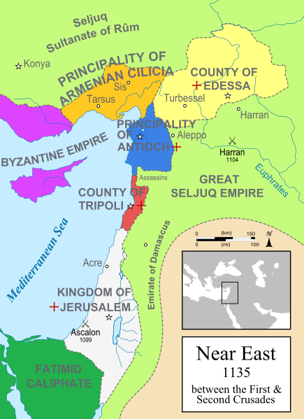
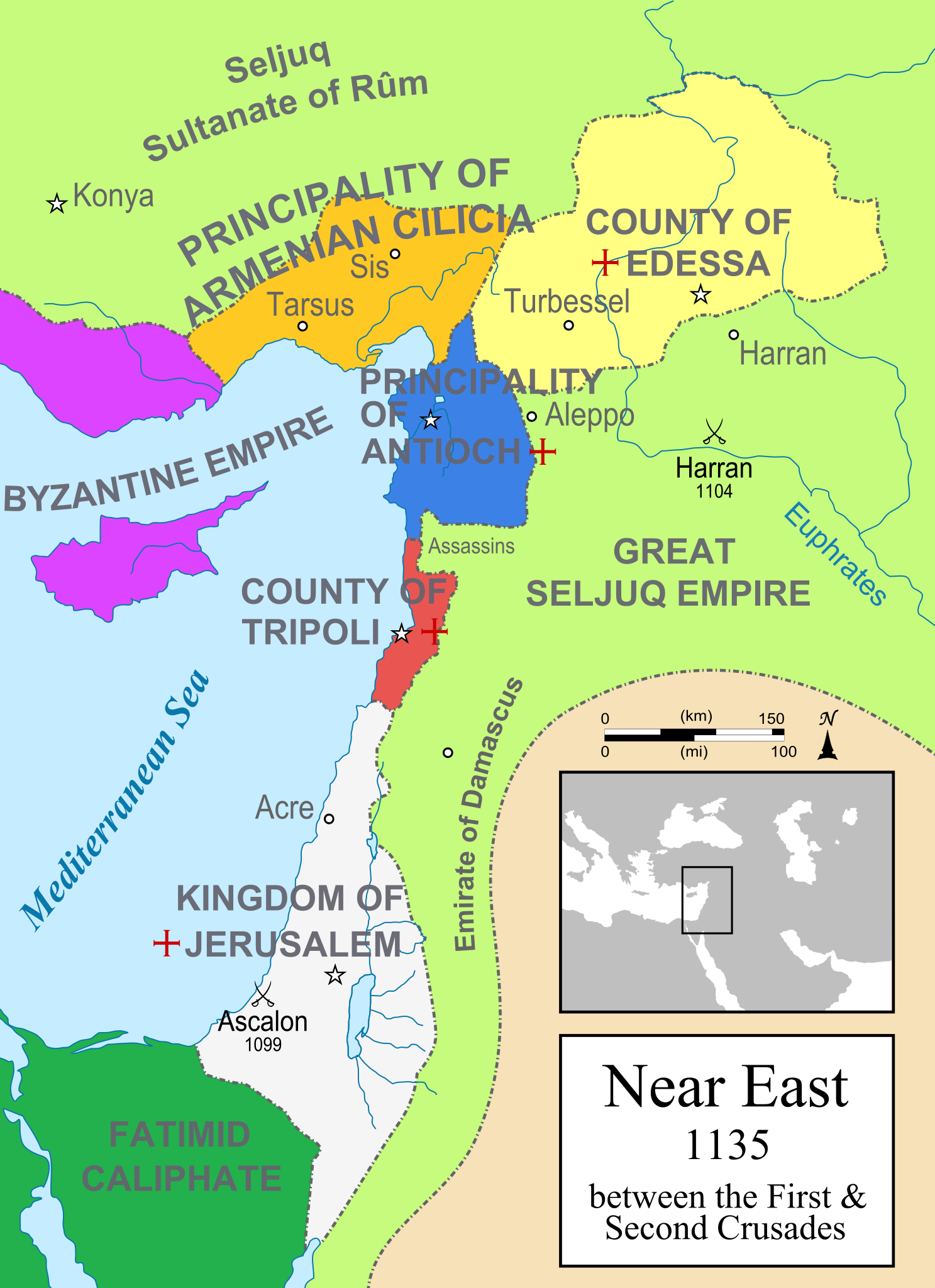
A political map of the Near East in 1135 CE. Crusader states are marked with a red cross.
Buod[baguhin]
| Paglalarawan |
[]
Čeština: Politická mapa Blízkého východu v roce 1135. Deutsch: Die Levante, 1135, zwischen den Ersten und Zweiten Kreuzzügen. Kreuzzugsstaaten sind mit einem roten Kreuz gekennzeichnet Eesti: Lähis-Ida (1135) Español: Oriente Próximo en 1135, entre la primera y segunda cruzadas. Esperanto: Politika mapo de Levantenio dum 1135, inter la krucmilitaroj unuaj kaj duaj. Français : Carte politique du Proche-Orient en 1135, entre la Première et la Seconde Croisades. les États latins d'Orient sont marqués d'une croix rouge. Italiano: Carta politica del Vicino Oriente nel 1135. Magyar: A Közel-Kelet térképe 1135-ben. Polski: Mapa polityczna Bliskiego Wschodu w roku 1135, w okresie II krucjaty. Ελληνικά: Πολιτικός χάρτης της Μέσης Ανατολής το 1135, ανάμεσα στην πρώτη και τη δεύτερη Σταυροφορία Македонски: Политичка карта на Блискиот Исток во 1135 г. Крстоносните држави се означени со црвени крстови. Русский: Карта Ближнего Востока в 1135 г. Српски / srpski: Politička karta Bliskog Istoka 1135. godine, između Prvog i Drugog krstaškog pohoda. Krstaške države su označene crvenim krstom. ქართული: ახლო აღმოსავლეთი 1135 წელს ไทย: แผนที่ตะวันออกกลาง (คศ. 1135) ระหว่างครูเสดครั้งที่ 1 และครั่งที่ 2 中文: 一副关于1135年近东地区局势的地图,标注红色十字的为十字军国家 العربية : الدويلات الصليبية والدول الإسلامية المجاورة لها في الفترة بين الحملتين الصليبيتين الأولى والثانية. فارسی : نسخه فارسی |
||
| Pinanggalingan | Sariling gawa | ||
| May-akda | MapMaster | ||
| Iba pang mga bersyon |
[]
See also[baguhin] |
||
| SVG genesis |


-ka.png)


References[baguhin]
- Bjorklund, Oddvar; Holmboe, Haakon; Rohr, Anders (1970) Historical Atlas of the World, Barnes & Noble, NY, SBN: 389-00253-4.
- Asia Minor and the Crusader states, c. 1140 from Findlay, Alexander G. (1849) Classical Atlas of Ancient Geography.
- Map of the Crusader states from Muir's Historical Atlas (1911)
Paglilisensiya[baguhin]
Ako, na may karapatang-ari ng akdang ito, ang naglalathala nito alinsunod sa ilalim ng sumusunod na mga lisensya:

|
Pinapayagan ang pagkopya, pamamahagi, at/o pagbabago sa dokumentong ito sa ilalim ng mga nakasaad sa GNU Free Documentation License, Bersyon 1.2 o kahit anong mas bagong bersyong nilathala ng Free Software Foundation; nang walang pabago-bagong bahagi, walang teksto sa front-cover, at walang teksto sa back-cover. May nakalagay na kopya ng lisensiya sa bahaging pinamagatang GNU Free Documentation License. |
| Lisensyado ang file na ito sa ilalim ng lisensiyang Creative Commons Attribution-Share Alike 3.0 Unported. | ||
| ||
| Ang tatak ng paglilisensiya ay idinagdag sa talaksang ito bilang bahagi ng pagsasapanahon ng paglilinsensiya ng GFDL . |
derivative works[baguhin]
Derivative works of this file:
Nakaraan ng file
Pindutin ang isang petsa/oras para makita ang file noong puntong yon.
| Petsa/Oras | Thumbnail | Sukat | Tagagamit | Komento | |
|---|---|---|---|---|---|
| ngayon | 21:01, 19 Marso 2015 | | 955 × 1,315 (418 KB) | Denniss (usapan | ambag) | Reverted to version as of 09:13, 25 July 2012 |
| 13:03, 19 Marso 2015 |  | 955 × 1,315 (433 KB) | Dorudgar (usapan | ambag) | Translation from English to Arabic الترجمة من الإنگليزية إلى العربية | |
| 09:13, 25 Hulyo 2012 |  | 955 × 1,315 (418 KB) | HorsefaCe (usapan | ambag) | Cilicia wan't a kingdom yet | |
| 09:08, 25 Hulyo 2012 |  | 955 × 1,315 (120 KB) | HorsefaCe (usapan | ambag) | A Chinese version. | |
| 11:48, 12 Hulyo 2010 |  | 955 × 1,315 (418 KB) | Malus Catulus (usapan | ambag) | Cilicia wan't a kingdom yet | |
| 10:59, 12 Hulyo 2010 |  | 955 × 1,315 (424 KB) | Malus Catulus (usapan | ambag) | Corrected burid dynasty | |
| 22:01, 11 Hulyo 2010 |  | 955 × 1,315 (418 KB) | Malus Catulus (usapan | ambag) | Final tweaks | |
| 21:52, 11 Hulyo 2010 |  | 955 × 1,315 (403 KB) | Malus Catulus (usapan | ambag) | Now complies with w3c so I hope the box is gone | |
| 21:22, 11 Hulyo 2010 |  | 955 × 1,315 (403 KB) | Malus Catulus (usapan | ambag) | Trying to remove black box | |
| 21:18, 11 Hulyo 2010 |  | 955 × 1,315 (402 KB) | Malus Catulus (usapan | ambag) | Forgot to convert Med. sea and Euphrates to path |
Hindi mo mao-overwrite ang file na ito.
Paggamit sa file
Ginagamit ng sumusunod na pahina ang file na ito:
- Atlas of Cyprus
- Atlas of Israel
- Atlas of Palestine
- Atlas of the Levant
- Levant
- User:Malus Catulus
- User:MapMaster
- File:CiliciaPrincipadoDeAntioquíaYCondadoDeTrípoli.svg
- File:Crusader States (1135)-ka.png
- File:Lähis-Ida 1135.png
- File:Map Crusader states 1135-ar.png
- File:Map Crusader states 1135-cs.svg
- File:Map Crusader states 1135-de.svg
- File:Map Crusader states 1135-de2.svg
- File:Map Crusader states 1135-el.svg
- File:Map Crusader states 1135-en.svg
- File:Map Crusader states 1135-eo.svg
- File:Map Crusader states 1135-es.svg
- File:Map Crusader states 1135-es2.svg
- File:Map Crusader states 1135-fr.svg
- File:Map Crusader states 1135-fr2.svg
- File:Map Crusader states 1135-hu.svg
- File:Map Crusader states 1135-hy.svg
- File:Map Crusader states 1135-it.png
- File:Map Crusader states 1135-jp.png
- File:Map Crusader states 1135-mk.svg
- File:Map Crusader states 1135-nl.svg
- File:Map Crusader states 1135-pl.png
- File:Map Crusader states 1135-pl.svg
- File:Map Crusader states 1135-pt.svg
- File:Map Crusader states 1135-ru.svg
- File:Map Crusader states 1135-zh.svg
- File:Map Crusads states 1135-fa.png
- File:MapofTripoli.png
- File:Near East 1135.svg (redirect ng file)
- User:MapMaster
- Atlas of Cyprus
- Atlas of Israel
- File:Principality of Antioch locator.svg
- Atlas of Palestine
- User:Malus Catulus
- File:Map Crusader states 1135-cs.svg
- File:Map Crusader states 1135-es2.svg
- File:Map Crusader states 1135-ar.png
- Levant
- File:Map Crusader states 1135-pt.svg
- File:Map Crusader states 1135-es.svg
- File:CiliciaPrincipadoDeAntioquíaYCondadoDeTrípoli.svg
- File:Map Crusader states 1135-hu.svg
- File:PrincipadodeAntioquía.png
- File:MapofTripoli.png
- File:PrincipadodeAntioquía.png
- File:Principality of Antioch locator.svg
- File:Second Crusade-ar.svg
- File:The Crusader States in 1135-ar.svg
- File:The Crusader States in 1135.svg
- Template:Other versions/Map Crusader states 1135
- Category:County of Tripoli
- Category:Kingdom of Jerusalem
- Category:Princes of Antioch
- Category:Principality of Antioch
Pandaigdigang paggamit sa file
Ginagamit ng mga sumusunod na wiki ang file na ito:
- Paggamit sa an.wikipedia.org
- Paggamit sa ar.wikipedia.org
- Paggamit sa arz.wikipedia.org
- Paggamit sa ast.wikipedia.org
- Paggamit sa azb.wikipedia.org
- Paggamit sa az.wikipedia.org
- Paggamit sa ba.wikipedia.org
- Paggamit sa be.wikipedia.org
- Paggamit sa bg.wikipedia.org
- Paggamit sa bn.wikipedia.org
- Paggamit sa br.wikipedia.org
- Paggamit sa bxr.wikipedia.org
- Paggamit sa ckb.wikipedia.org
- Paggamit sa cs.wikipedia.org
- Paggamit sa cy.wikipedia.org
- Paggamit sa da.wikipedia.org
Tingnan ang karagdagang pandaigdigang paggamit sa file na ito.
Metadata
Mga kategorya:
- Crusader states
- Maps of Cilicia
- Maps of the County of Edessa
- Maps of the County of Tripoli
- Maps of the Kingdom of Jerusalem
- Maps of the Principality of Antioch
- Maps of Crusader states
- Maps of the history of Cyprus
- Maps of the history of the Levant
- Maps of the history of the Middle East
- Maps showing 12th-century history
- English-language SVG maps showing history
- Maps of the Seljuk Empire
- Greater Israel