File:Map Europe 1923-en.svg
跳至導覽
跳至搜尋

此 SVG 檔案的 PNG 預覽的大小:800 × 543 像素。 其他解析度:320 × 217 像素 | 640 × 434 像素 | 1,024 × 695 像素 | 1,280 × 869 像素 | 2,560 × 1,738 像素 | 1,037 × 704 像素。
原始檔案 (SVG 檔案,表面大小:1,037 × 704 像素,檔案大小:230 KB)
說明
說明
添加單行說明來描述出檔案所代表的內容
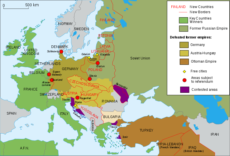
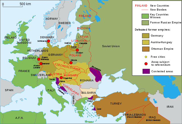
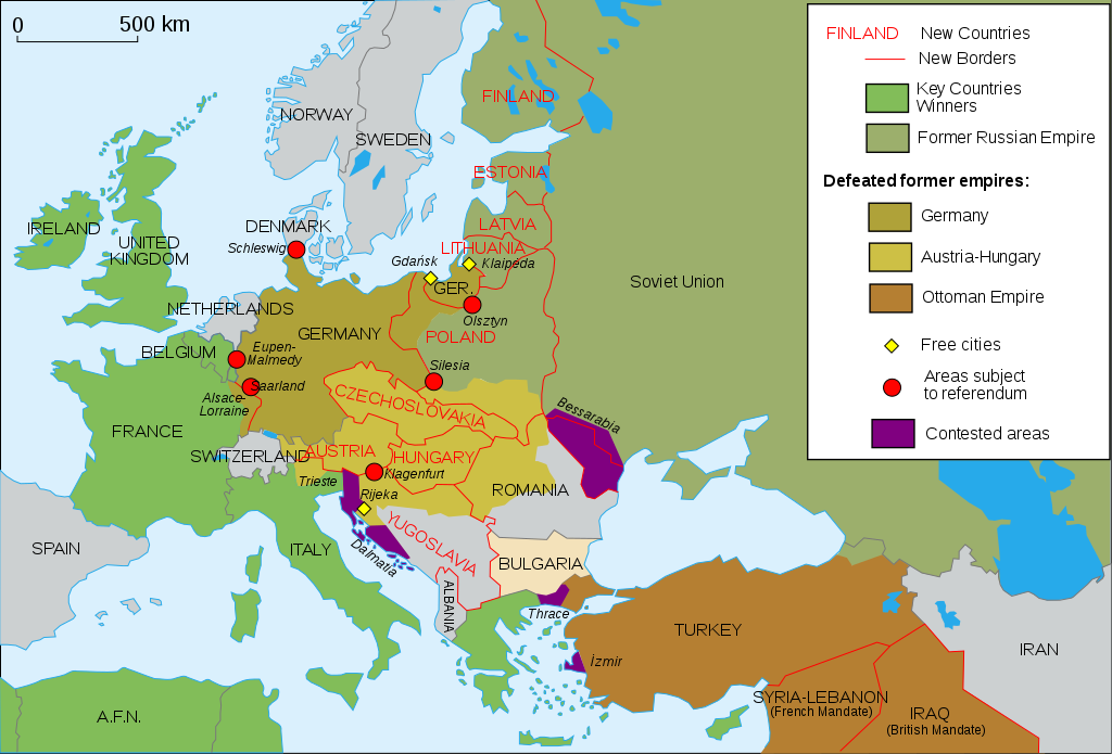
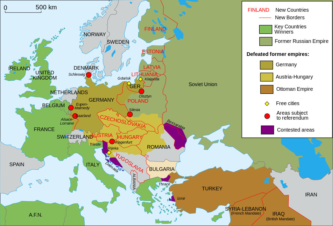
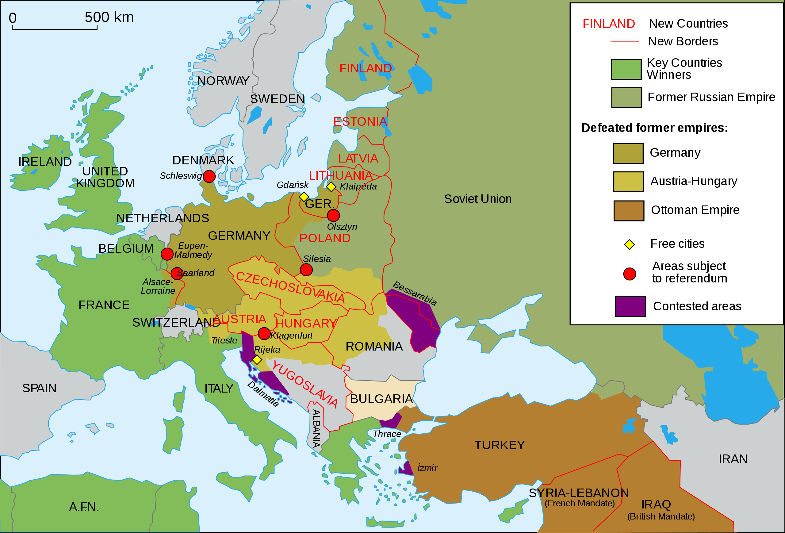
Map of Europe and western Asia in 1923
| 描述 |
English: Map of Europe and Western Asia in 1923 after World War I Español: Mapa de Europa y Asia en 1923 Français : Carte de l'Europe en 1923. Português: Mapa da Europa e da Ásia em 1923 অসমীয়া: প্ৰথম বিশ্বযুদ্ধৰ পিছত ১৯২৩ চনত ইউৰোপ আৰু পশ্চিম এছিয়াৰ মানচিত্ৰ বাংলা : প্রথম বিশ্বযুদ্ধের পর ১৯২৩ সালে ইউরোপ ও পশ্চিম এশিয়ার মানচিত্র |
| 日期 | (UTC) |
| 來源 | |
| 作者 |
|
| 其他版本 |
Derivative works of this file: []
|
| SVG開發 |


我,本作品的著作權持有者,決定用以下授權條款發佈本作品:
原始上傳日誌
[編輯]
This image is a derivative work of the following images:
- File:Map_Europe_1923-fr.svg licensed with Cc-by-sa-2.5,2.0,1.0, Cc-by-sa-2.5,2.0,1.0/en
- 2007-04-19T18:31:16Z Bibi Saint-Pol 1037x704 (191242 Bytes) {{Information |Description= {{en|Map of Europe in 1923.}} {{fr|Carte de l'Europe en 1923.}} |Source=Own work |Date=2007-02-16 |Author=[[User:Historicair|Historicair]] |Permission={{self2|GFDL|cc-by-sa-2.5,2.0,1.0}} |other_ver
Uploaded with derivativeFX

|
This SVG file contains embedded text that can be translated into your language, using any capable SVG editor, text editor or the SVG Translate tool. For more information see: About translating SVG files. |
檔案歷史
點選日期/時間以檢視該時間的檔案版本。
| 日期/時間 | 縮圖 | 尺寸 | 用戶 | 備註 | |
|---|---|---|---|---|---|
| 目前 | 2024年5月17日 (五) 10:43 | | 1,037 × 704(230 KB) | Andrei Stroe(對話 | 貢獻) | File uploaded using svgtranslate tool (https://svgtranslate.toolforge.org/). Added translation for ro. |
| 2015年11月11日 (三) 13:42 |  | 1,037 × 704(188 KB) | Oosterhagen(對話 | 貢獻) | The Netherlands as neutral | |
| 2015年8月15日 (六) 14:24 |  | 1,037 × 704(177 KB) | Fluteflute(對話 | 貢獻) | Correct misspelling. Sweeden -> Sweden | |
| 2009年1月13日 (二) 16:21 |  | 1,037 × 704(187 KB) | Fluteflute(對話 | 貢獻) | small text changes | |
| 2009年1月13日 (二) 16:17 |  | 1,037 × 704(187 KB) | Fluteflute(對話 | 貢獻) | {{Information |Description={{en|Map of Europe in 1923.}} {{fr|Carte de l'Europe en 1923.}} |Source=*File:Map_Europe_1923-fr.svg |Date=2009-01-13 16:16 (UTC) |Author=*derivative work: ~~~ *File:Map_Europe_1923-fr.svg: [[User:Historicair|Histori |
無法覆蓋此檔案。
檔案用途
下列23個頁面有用到此檔案:
- Atlas of World War I
- User:Magog the Ogre/Maps of conflicts/2015 August
- User:Magog the Ogre/Maps of conflicts/2015 November
- User:Magog the Ogre/Maps of conflicts/2024 May
- File:Map Europe 1923-ar.svg
- File:Map Europe 1923-bn.svg
- File:Map Europe 1923-bs.svg
- File:Map Europe 1923-bxr.svg
- File:Map Europe 1923-ca.svg
- File:Map Europe 1923-de.svg
- File:Map Europe 1923-el.svg
- File:Map Europe 1923-en.svg
- File:Map Europe 1923-es.svg
- File:Map Europe 1923-fr.svg
- File:Map Europe 1923-hr.svg
- File:Map Europe 1923-hu.svg
- File:Map Europe 1923-it.svg
- File:Map Europe 1923-mk.svg
- File:Map Europe 1923-nl.svg
- File:Map Europe 1923-pt-br.svg
- File:Map Europe 1923-ru.svg
- File:ஐரோப்பிய வரைபடம் 1923.svg
- Template:Other versions/Map Europe 1923
全域檔案使用狀況
以下其他 wiki 使用了這個檔案:
- af.wikipedia.org 的使用狀況
- ar.wikipedia.org 的使用狀況
- azb.wikipedia.org 的使用狀況
- az.wikipedia.org 的使用狀況
- be-tarask.wikipedia.org 的使用狀況
- bn.wikibooks.org 的使用狀況
- ca.wikipedia.org 的使用狀況
- ckb.wikipedia.org 的使用狀況
- cy.wikipedia.org 的使用狀況
- en.wikipedia.org 的使用狀況
- Molotov–Ribbentrop Pact
- Nation state
- Self-determination
- Treaty of Versailles
- Woodrow Wilson
- 20th century
- Flight and expulsion of Germans (1944–1950)
- Balkanization
- Aftermath of World War I
- Revanchism
- Causes of World War II
- Territorial evolution of Russia
- History of Western civilization
- World War I
- List of national border changes (1914–present)
- Presidency of Woodrow Wilson
- Presidency of Warren G. Harding
- January 1920
- Wikipedia:Graphics Lab/Map workshop/Archive/2016
- Portal:Modern history
- Wikipedia:WikiProject Military history/News/June 2019/Op-ed
- History of U.S. foreign policy, 1913–1933
- User:Sm8900/harding
- User:Falcaorib/Europe
- en.wikibooks.org 的使用狀況
- eo.wikipedia.org 的使用狀況
- eu.wikipedia.org 的使用狀況
- fa.wikipedia.org 的使用狀況
- fi.wikipedia.org 的使用狀況
- fi.wikibooks.org 的使用狀況
- ga.wikipedia.org 的使用狀況
- hy.wikipedia.org 的使用狀況
- hyw.wikipedia.org 的使用狀況
- id.wikipedia.org 的使用狀況
檢視此檔案的更多全域使用狀況。