File:Map Europe 1923-en.svg
跳转到导航
跳转到搜索

此SVG文件的PNG预览的大小:800 × 543像素。 其他分辨率:320 × 217像素 | 640 × 434像素 | 1,024 × 695像素 | 1,280 × 869像素 | 2,560 × 1,738像素 | 1,037 × 704像素。
原始文件 (SVG文件,尺寸为1,037 × 704像素,文件大小:251 KB)
说明
说明
添加一行文字以描述该文件所表现的内容
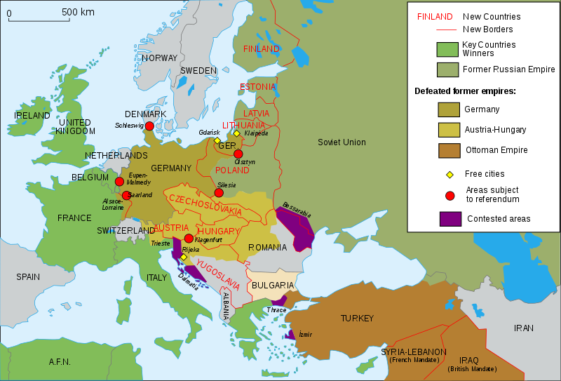
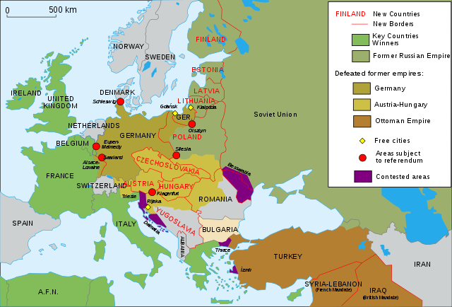
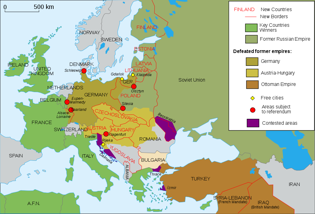
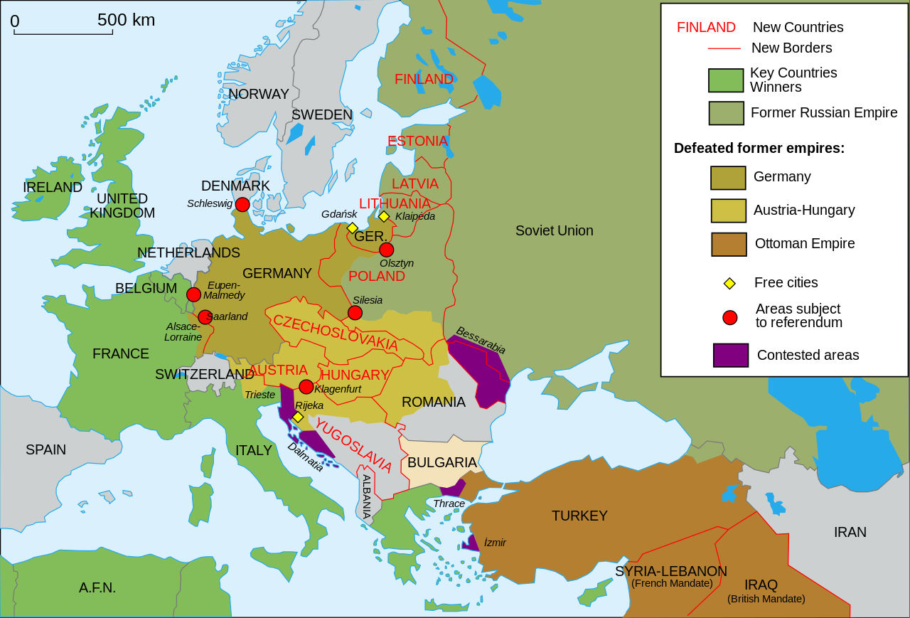
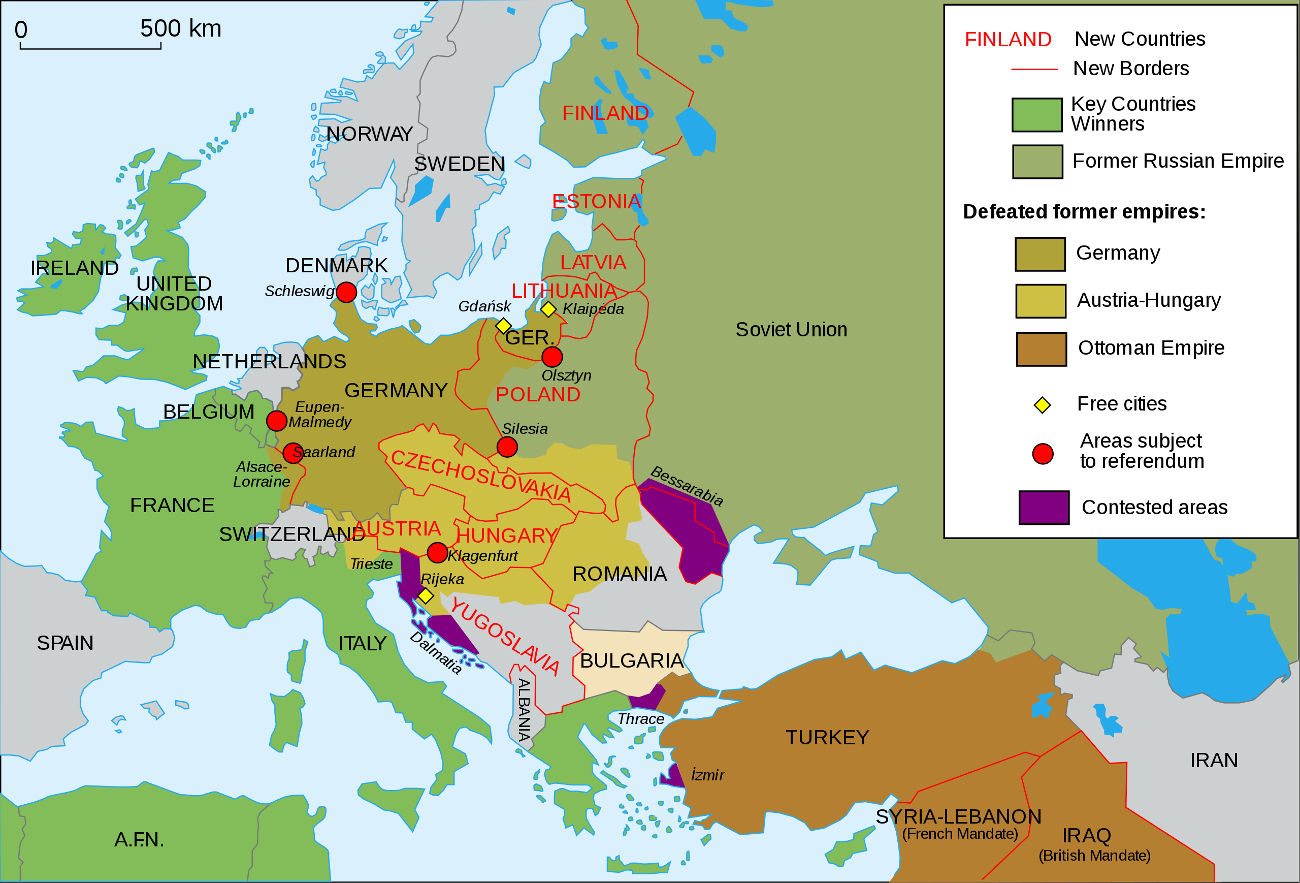
Map of Europe and western Asia in 1923
| 描述 |
English: Map of Europe and Western Asia in 1923 after World War I Español: Mapa de Europa y Asia en 1923 Français : Carte de l'Europe en 1923. Português: Mapa da Europa e da Ásia em 1923 অসমীয়া: প্ৰথম বিশ্বযুদ্ধৰ পিছত ১৯২৩ চনত ইউৰোপ আৰু পশ্চিম এছিয়াৰ মানচিত্ৰ বাংলা : প্রথম বিশ্বযুদ্ধের পর ১৯২৩ সালে ইউরোপ ও পশ্চিম এশিয়ার মানচিত্র |
| 日期 | (UTC) |
| 来源 | |
| 作者 |
|
| 其他版本 |
Derivative works of this file: []
|
| SVG开发 |


我,本作品著作权人,特此采用以下许可协议发表本作品:
- 您可以自由地:
- 共享 – 复制、发行并传播本作品
- 修改 – 改编作品
- 惟须遵守下列条件:
- 署名 – 您必须对作品进行署名,提供授权条款的链接,并说明是否对原始内容进行了更改。您可以用任何合理的方式来署名,但不得以任何方式表明许可人认可您或您的使用。
- 相同方式共享 – 如果您再混合、转换或者基于本作品进行创作,您必须以与原先许可协议相同或相兼容的许可协议分发您贡献的作品。
原始上传日志
[编辑]
This image is a derivative work of the following images:
- File:Map_Europe_1923-fr.svg licensed with Cc-by-sa-2.5,2.0,1.0, Cc-by-sa-2.5,2.0,1.0/en
- 2007-04-19T18:31:16Z Bibi Saint-Pol 1037x704 (191242 Bytes) {{Information |Description= {{en|Map of Europe in 1923.}} {{fr|Carte de l'Europe en 1923.}} |Source=Own work |Date=2007-02-16 |Author=[[User:Historicair|Historicair]] |Permission={{self2|GFDL|cc-by-sa-2.5,2.0,1.0}} |other_ver
Uploaded with derivativeFX

|
This SVG file contains embedded text that can be translated into your language, using any capable SVG editor, text editor or the SVG Translate tool. For more information see: About translating SVG files. |
文件历史
点击某个日期/时间查看对应时刻的文件。
| 日期/时间 | 缩略图 | 大小 | 用户 | 备注 | |
|---|---|---|---|---|---|
| 当前 | 2024年7月30日 (二) 00:49 | | 1,037 × 704(251 KB) | Ratherous(留言 | 贡献) | Aland Islands |
| 2024年5月17日 (五) 10:43 |  | 1,037 × 704(230 KB) | Andrei Stroe(留言 | 贡献) | File uploaded using svgtranslate tool (https://svgtranslate.toolforge.org/). Added translation for ro. | |
| 2015年11月11日 (三) 13:42 |  | 1,037 × 704(188 KB) | Oosterhagen(留言 | 贡献) | The Netherlands as neutral | |
| 2015年8月15日 (六) 14:24 |  | 1,037 × 704(177 KB) | Fluteflute(留言 | 贡献) | Correct misspelling. Sweeden -> Sweden | |
| 2009年1月13日 (二) 16:21 |  | 1,037 × 704(187 KB) | Fluteflute(留言 | 贡献) | small text changes | |
| 2009年1月13日 (二) 16:17 |  | 1,037 × 704(187 KB) | Fluteflute(留言 | 贡献) | {{Information |Description={{en|Map of Europe in 1923.}} {{fr|Carte de l'Europe en 1923.}} |Source=*File:Map_Europe_1923-fr.svg |Date=2009-01-13 16:16 (UTC) |Author=*derivative work: ~~~ *File:Map_Europe_1923-fr.svg: [[User:Historicair|Histori |
您不可以覆盖此文件。
文件用途
以下24个页面使用本文件:
- Atlas of World War I
- User:Magog the Ogre/Maps of conflicts/2015 August
- User:Magog the Ogre/Maps of conflicts/2015 November
- User:Magog the Ogre/Maps of conflicts/2024 July
- User:Magog the Ogre/Maps of conflicts/2024 May
- File:Map Europe 1923-ar.svg
- File:Map Europe 1923-bn.svg
- File:Map Europe 1923-bs.svg
- File:Map Europe 1923-bxr.svg
- File:Map Europe 1923-ca.svg
- File:Map Europe 1923-de.svg
- File:Map Europe 1923-el.svg
- File:Map Europe 1923-en.svg
- File:Map Europe 1923-es.svg
- File:Map Europe 1923-fr.svg
- File:Map Europe 1923-hr.svg
- File:Map Europe 1923-hu.svg
- File:Map Europe 1923-it.svg
- File:Map Europe 1923-mk.svg
- File:Map Europe 1923-nl.svg
- File:Map Europe 1923-pt-br.svg
- File:Map Europe 1923-ru.svg
- File:ஐரோப்பிய வரைபடம் 1923.svg
- Template:Other versions/Map Europe 1923
全域文件用途
以下其他wiki使用此文件:
- af.wikipedia.org上的用途
- ar.wikipedia.org上的用途
- azb.wikipedia.org上的用途
- az.wikipedia.org上的用途
- be-tarask.wikipedia.org上的用途
- bn.wikibooks.org上的用途
- ca.wikipedia.org上的用途
- ckb.wikipedia.org上的用途
- cy.wikipedia.org上的用途
- en.wikipedia.org上的用途
- Molotov–Ribbentrop Pact
- Nation state
- Self-determination
- Treaty of Versailles
- Woodrow Wilson
- 20th century
- Flight and expulsion of Germans (1944–1950)
- Balkanization
- Aftermath of World War I
- Revanchism
- Causes of World War II
- Territorial evolution of Russia
- History of Western civilization
- World War I
- List of national border changes (1914–present)
- Presidency of Woodrow Wilson
- Presidency of Warren G. Harding
- January 1920
- Wikipedia:Graphics Lab/Map workshop/Archive/2016
- Portal:Modern history
- Wikipedia:WikiProject Military history/News/June 2019/Op-ed
- History of U.S. foreign policy, 1913–1933
- User:Sm8900/harding
- User:Falcaorib/Europe
- 1917 Franco-Russian agreement
- en.wikibooks.org上的用途
- eo.wikipedia.org上的用途
- eu.wikipedia.org上的用途
- fa.wikipedia.org上的用途
- fi.wikipedia.org上的用途
- fi.wikibooks.org上的用途
- ga.wikipedia.org上的用途
- hy.wikipedia.org上的用途
查看此文件的更多全域用途。