File:Map Europe alliances 1914-en.svg
Spring til navigation
Spring til søgning

Size of this PNG preview of this SVG file: 800 × 473 pixels. Andre opløsninger: 320 × 189 pixels | 640 × 379 pixels | 1.024 × 606 pixels | 1.280 × 758 pixels | 2.560 × 1.515 pixels | 1.002 × 593 pixels.
Oprindelig fil (SVG fil, basisstørrelse 1.002 × 593 pixels, filstørrelse: 97 KB)
Captions
Captions
Tilføj en kort forklaring på en enkelt linje om hvad filen viser
| Beskrivelse |
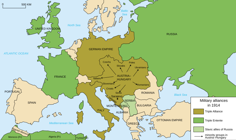
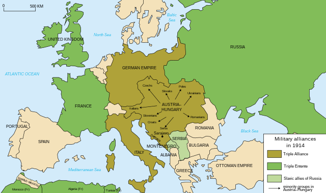
Deutsch: Karte von Militärbündnisse in Europa in 1914, (Englisch) English: Map of military alliances of Europe in 1914. (English) Français : Carte des alliances militaires en Europe en 1914. (Anglais) Русский: Схема военных альянсов в Европе в 1914 г. (англ.) |
| Dato |
|
| Kilde | Translated in English from French SVG Map_Europe_alliances_1914-fr.svg |
| Forfatter |
|
| Andre versioner |
Derivative works of this file: Map Europe alliances 1914-he.svg
[] .gif)
|


W3C-validity not checked.

|
SVG-filen indeholder indlejret tekst som let kan oversættes til dit sprog ved hjælp af [toolforge:svgtranslate/File:Map_Europe_alliances_1914-en.svglink dette automatiske værktøj]. Lær mere her. |
| Dette er et retoucheret billede, hvilket betyder, at det er blevet digitalt ændret fra sin oprindelige version. Ændringer: English translation. Originalen kan ses her: Map Europe alliances 1914-fr.svg. Ændringer blev udført af Fluteflute.
|
Jeg, dette værks ophavsretsindehaver, publicerer hermed værket under den følgende licens:
Denne fil er udgivet under Creative Commons Navngivelse – Del på samme vilkår 2.5 Generisk, 2.0 Generisk og 1.0 Generisk-licensen.
- Du må frit:
- at dele – at kopiere, distribuere og overføre værket
- at remixe – at tilpasse værket
- Under følgende vilkår:
- kreditering – Du skal give passende kreditering, angive et link til licensen, og oplyse om der er foretaget ændringer. Du må gøre det på enhver fornuftig måde, men ikke på en måde der antyder at licensgiveren godkender dig eller din anvendelse.
- deling på samme vilkår – Hvis du bearbejder, ændrer eller bygger videre på dette værk, skal du distribuere dine bidrag under den samme eller en kompatibel licens som originalen.
Oprindelig oplægningslog[redigér]
This image is a derivative work of the following images:
- File:Map_Europe_alliances_1914-fr.svg licensed with Cc-by-sa-2.5,2.0,1.0, Cc-by-sa-2.5,2.0,1.0/en
- 2007-02-26T23:36:35Z Bibi Saint-Pol 998x593 (100171 Bytes) {{Information |Description= {{fr|Carte des alliances militaires en Europe en 1914.}} |Source=Création personnelle(version renommée de [[:Image:Les rivalités en Europe en 1914.svg]]) |Date=2006-10-31 |Author=[[User:Histori
Uploaded with derivativeFX
Filhistorik
Klik på en dato/tid for at se filen som den så ud på det tidspunkt.
| Dato/tid | Miniaturebillede | Dimensioner | Bruger | Kommentar | |
|---|---|---|---|---|---|
| nuværende | 4. apr. 2021, 20:59 | | 1.002 × 593 (97 KB) | Andrewtips (diskussion | bidrag) | File uploaded using svgtranslate tool (https://svgtranslate.toolforge.org/). Added translation for zh-hant. |
| 4. aug. 2020, 21:02 |  | 1.002 × 593 (92 KB) | Ionaki (diskussion | bidrag) | File uploaded using svgtranslate tool (https://svgtranslate.toolforge.org/). Added translation for eu. | |
| 4. aug. 2020, 21:02 |  | 1.002 × 593 (92 KB) | Ionaki (diskussion | bidrag) | File uploaded using svgtranslate tool (https://svgtranslate.toolforge.org/). Added translation for eu. | |
| 4. aug. 2020, 20:59 |  | 1.002 × 593 (92 KB) | Ionaki (diskussion | bidrag) | File uploaded using svgtranslate tool (https://svgtranslate.toolforge.org/). Added translation for eu. | |
| 2. aug. 2020, 15:14 |  | 1.002 × 593 (72 KB) | Bogomolov.PL (diskussion | bidrag) | reservoirs on Dnieper, Don and Volga rivers were built after Second WW, erased. Romania, Serbia, Montenegro, Albania and Bulgaria borders corrected | |
| 21. jan. 2017, 11:22 |  | 1.002 × 593 (75 KB) | Perey (diskussion | bidrag) | This portrays the Triple Alliance, not the Central Powers (of which Italy was never one). Error introduced in version dated 2010-03-07 by Mnmazur (talk). | |
| 28. nov. 2015, 21:18 |  | 1.002 × 593 (75 KB) | Turnless (diskussion | bidrag) | Aland Islands | |
| 2. jan. 2015, 12:25 |  | 1.002 × 593 (75 KB) | Borodun (diskussion | bidrag) | Moonsund archipelago is territory of Russia | |
| 2. jan. 2015, 00:30 |  | 1.002 × 593 (70 KB) | ZYjacklin (diskussion | bidrag) | Capitalize the name for Romania. | |
| 17. nov. 2010, 16:49 |  | 1.002 × 593 (70 KB) | Ras67 (diskussion | bidrag) | "cropped" and minor things |
Du kan ikke overskrive denne fil.
Filanvendelse
De følgende 44 sider bruger denne fil:
- User:M0tty/WWI
- User:Magog the Ogre/Maps of conflicts/2015 November
- User:Magog the Ogre/Maps of conflicts/2017 January
- User:Magog the Ogre/Maps of conflicts/2020 August
- User:Magog the Ogre/Maps of conflicts/2021 April
- User:Magog the Ogre/Multilingual legend/2020 August 1-10
- User:Magog the Ogre/Multilingual legend/2021 April 1-10
- File:1914 ஐரோப்பியக் கூட்டணிகள்.svg
- File:1914년 유럽의 군사동맹지도.PNG
- File:Alliances militaires en Europe 1914-1918-hy.png
- File:Map Europe WW1 Frontlines as of 1916.png
- File:Map Europe alliances 1914-ar.svg
- File:Map Europe alliances 1914-az.svg
- File:Map Europe alliances 1914-bg.svg
- File:Map Europe alliances 1914-bn.svg
- File:Map Europe alliances 1914-ce.svg
- File:Map Europe alliances 1914-cs.svg
- File:Map Europe alliances 1914-de.svg
- File:Map Europe alliances 1914-el.svg
- File:Map Europe alliances 1914-en.svg
- File:Map Europe alliances 1914-eo.svg
- File:Map Europe alliances 1914-es.svg
- File:Map Europe alliances 1914-fr.svg
- File:Map Europe alliances 1914-gl.svg
- File:Map Europe alliances 1914-he.svg
- File:Map Europe alliances 1914-hr.svg
- File:Map Europe alliances 1914-hu.svg
- File:Map Europe alliances 1914-hy.jpg
- File:Map Europe alliances 1914-it.svg
- File:Map Europe alliances 1914-ko.svg
- File:Map Europe alliances 1914-la.svg
- File:Map Europe alliances 1914-lt.svg
- File:Map Europe alliances 1914-mk.svg
- File:Map Europe alliances 1914-nl.svg
- File:Map Europe alliances 1914-no.svg
- File:Map Europe alliances 1914-ro.svg
- File:Map Europe alliances 1914-ru.svg
- File:Map Europe alliances 1914-sr.svg
- File:Map Europe alliances 1914-sv.svg
- File:Map Europe alliances 1914-ta.png
- File:Map Europe alliances 1914-uk.svg
- File:PotenciasEnLiza1914-pt.svg
- File:PotenciasEnLiza1914.svg
- Template:Other versions/Map Europe alliances 1914
Global filanvendelse
Følgende andre wikier anvender denne fil:
- Anvendelser på ar.wikipedia.org
- Anvendelser på bcl.wikipedia.org
- Anvendelser på bh.wikipedia.org
- Anvendelser på br.wikipedia.org
- Anvendelser på cy.wikipedia.org
- Anvendelser på da.wikipedia.org
- Anvendelser på el.wikipedia.org
- Anvendelser på en.wikipedia.org
- Franz Joseph I of Austria
- Triple Alliance (1882)
- Military alliance
- Triple Entente
- Yugoslav Committee
- Treaty of London (1915)
- Switzerland during the World Wars
- Polish Legions in World War I
- Two-front war
- History of Western civilization
- World War I
- France–Russia relations
- 1914
- European balance of power
- Wikipedia:Graphics Lab/Illustration workshop/Archive/Nov 2010
- Sweden during World War I
- Talk:World War I/Archive 16
- User:Chickstarr404/Gather lists/16060 – "Paris 1919" by Margaret Macmillan
- User:Chickstarr404/Gather lists
- User:Falcaorib
- Friedrich von Pourtalès
- Draft:Participants of World War I
- Anvendelser på en.wikibooks.org
- Anvendelser på en.wiktionary.org
- Anvendelser på et.wikipedia.org
- Anvendelser på eu.wikipedia.org
- Anvendelser på fa.wikipedia.org
- Anvendelser på fiu-vro.wikipedia.org
- Anvendelser på fi.wikipedia.org
- Anvendelser på fi.wikibooks.org
- Anvendelser på fo.wikipedia.org
- Anvendelser på fy.wikipedia.org
Vis flere globale anvendelser af denne fil.