File:Map Europe alliances 1914-en.svg

Πρωτότυπο αρχείο (Αρχείο SVG, ονομαστικό μέγεθος 1.002 × 593 εικονοστοιχεία, μέγεθος αρχείου: 97 KB)
Λεζάντες
Λεζάντες
| Περιγραφή |
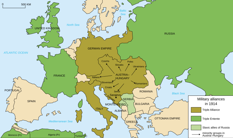
Deutsch: Karte von Militärbündnisse in Europa in 1914, (Englisch) English: Map of military alliances of Europe in 1914. (English) Français : Carte des alliances militaires en Europe en 1914. (Anglais) Русский: Схема военных альянсов в Европе в 1914 г. (англ.) |
| Ημερομηνία |
|
| Πηγή | Translated in English from French SVG Map_Europe_alliances_1914-fr.svg |
| Δημιουργός |
|
| άλλες εκδόσεις |
Derivative works of this file: Map Europe alliances 1914-he.svg
[]
|
.gif)


|
Αυτό το αρχείο SVG περιέχει κείμενο που μπορεί εύκολα να μεταφραστεί χρησιμοποιώντας [toolforge:svgtranslate/File:Map_Europe_alliances_1914-en.svglink αυτό το αυτόματο εργαλείο]. Περισσότερα. |
| Αυτή είναι μία ρετουσαρισμένη εικόνα, που σημαίνει ότι έχει μεταβληθεί ψηφιακά από την αρχική της έκδοση. Τροποποιήσεις: English translation. Η πρωτότυπη μπορεί να βρεθεί εδώ: Map Europe alliances 1914-fr.svg. Οι τροποποιήσεις έγιναν από τον Fluteflute.
|
- Είστε ελεύθερος:
- να μοιραστείτε – να αντιγράψετε, διανέμετε και να μεταδώσετε το έργο
- να διασκευάσετε – να τροποποιήσετε το έργο
- Υπό τις ακόλουθες προϋποθέσεις:
- αναφορά προέλευσης – Θα πρέπει να κάνετε κατάλληλη αναφορά, να παρέχετε σύνδεσμο για την άδεια και να επισημάνετε εάν έγιναν αλλαγές. Μπορείτε να το κάνετε με οποιοδήποτε αιτιολογήσιμο λόγο, χωρίς όμως να εννοείται με οποιονδήποτε τρόπο ότι εγκρίνουν εσάς ή τη χρήση του έργου από εσάς.
- παρόμοια διανομή – Εάν αλλάξετε, τροποποιήσετε ή δημιουργήσετε πάνω στο έργο αυτό, μπορείτε να διανείμετε αυτό που θα προκύψει μόνο υπό τους όρους της ίδιας ή συμβατής άδειας με το πρωτότυπο.
Καταγραφές ανεβασμάτων πρωτότυπου αρχείου
[επεξεργασία]
This image is a derivative work of the following images:
- File:Map_Europe_alliances_1914-fr.svg licensed with Cc-by-sa-2.5,2.0,1.0, Cc-by-sa-2.5,2.0,1.0/en
- 2007-02-26T23:36:35Z Bibi Saint-Pol 998x593 (100171 Bytes) {{Information |Description= {{fr|Carte des alliances militaires en Europe en 1914.}} |Source=Création personnelle(version renommée de [[:Image:Les rivalités en Europe en 1914.svg]]) |Date=2006-10-31 |Author=[[User:Histori
Uploaded with derivativeFX
Ιστορικό αρχείου
Πατήστε σε μια ημερομηνία/ώρα για να δείτε το αρχείο όπως εμφανιζόταν εκείνη την χρονική στιγμή.
| Ημερομηνία/Ώρα | Μικρογραφία | Διαστάσεις | Χρήστης | Σχόλιο | |
|---|---|---|---|---|---|
| τρέχον | 20:59, 4 Απριλίου 2021 | | 1.002 × 593 (97 KB) | Andrewtips (συζήτηση | Συνεισφορά) | File uploaded using svgtranslate tool (https://svgtranslate.toolforge.org/). Added translation for zh-hant. |
| 21:02, 4 Αυγούστου 2020 |  | 1.002 × 593 (92 KB) | Ionaki (συζήτηση | Συνεισφορά) | File uploaded using svgtranslate tool (https://svgtranslate.toolforge.org/). Added translation for eu. | |
| 21:02, 4 Αυγούστου 2020 |  | 1.002 × 593 (92 KB) | Ionaki (συζήτηση | Συνεισφορά) | File uploaded using svgtranslate tool (https://svgtranslate.toolforge.org/). Added translation for eu. | |
| 20:59, 4 Αυγούστου 2020 |  | 1.002 × 593 (92 KB) | Ionaki (συζήτηση | Συνεισφορά) | File uploaded using svgtranslate tool (https://svgtranslate.toolforge.org/). Added translation for eu. | |
| 15:14, 2 Αυγούστου 2020 |  | 1.002 × 593 (72 KB) | Bogomolov.PL (συζήτηση | Συνεισφορά) | reservoirs on Dnieper, Don and Volga rivers were built after Second WW, erased. Romania, Serbia, Montenegro, Albania and Bulgaria borders corrected | |
| 11:22, 21 Ιανουαρίου 2017 |  | 1.002 × 593 (75 KB) | Perey (συζήτηση | Συνεισφορά) | This portrays the Triple Alliance, not the Central Powers (of which Italy was never one). Error introduced in version dated 2010-03-07 by Mnmazur (talk). | |
| 21:18, 28 Νοεμβρίου 2015 |  | 1.002 × 593 (75 KB) | Turnless (συζήτηση | Συνεισφορά) | Aland Islands | |
| 12:25, 2 Ιανουαρίου 2015 |  | 1.002 × 593 (75 KB) | Borodun (συζήτηση | Συνεισφορά) | Moonsund archipelago is territory of Russia | |
| 00:30, 2 Ιανουαρίου 2015 |  | 1.002 × 593 (70 KB) | ZYjacklin (συζήτηση | Συνεισφορά) | Capitalize the name for Romania. | |
| 16:49, 17 Νοεμβρίου 2010 |  | 1.002 × 593 (70 KB) | Ras67 (συζήτηση | Συνεισφορά) | "cropped" and minor things |
Δεν μπορείτε να αντικαταστήσετε αυτό το αρχείο.
Χρήση αρχείου
Οι ακόλουθες 45 σελίδες χρησιμοποιούν προς αυτό το αρχείο:
- User:M0tty/WWI
- User:Magog the Ogre/Maps of conflicts/2015 November
- User:Magog the Ogre/Maps of conflicts/2017 January
- User:Magog the Ogre/Maps of conflicts/2020 August
- User:Magog the Ogre/Maps of conflicts/2021 April
- User:Magog the Ogre/Multilingual legend/2020 August 1-10
- User:Magog the Ogre/Multilingual legend/2021 April 1-10
- File:1914 ஐரோப்பியக் கூட்டணிகள்.svg
- File:1914년 유럽의 군사동맹지도.PNG
- File:Alliances militaires en Europe 1914-1918-hy.png
- File:Kartenn aliañsoù Europa 1914-br.svg
- File:Map Europe WW1 Frontlines as of 1916.png
- File:Map Europe alliances 1914-ar.svg
- File:Map Europe alliances 1914-az.svg
- File:Map Europe alliances 1914-bg.svg
- File:Map Europe alliances 1914-bn.svg
- File:Map Europe alliances 1914-ce.svg
- File:Map Europe alliances 1914-cs.svg
- File:Map Europe alliances 1914-de.svg
- File:Map Europe alliances 1914-el.svg
- File:Map Europe alliances 1914-en.svg
- File:Map Europe alliances 1914-eo.svg
- File:Map Europe alliances 1914-es.svg
- File:Map Europe alliances 1914-fr.svg
- File:Map Europe alliances 1914-gl.svg
- File:Map Europe alliances 1914-he.svg
- File:Map Europe alliances 1914-hr.svg
- File:Map Europe alliances 1914-hu.svg
- File:Map Europe alliances 1914-hy.jpg
- File:Map Europe alliances 1914-it.svg
- File:Map Europe alliances 1914-ko.svg
- File:Map Europe alliances 1914-la.svg
- File:Map Europe alliances 1914-lt.svg
- File:Map Europe alliances 1914-mk.svg
- File:Map Europe alliances 1914-nl.svg
- File:Map Europe alliances 1914-no.svg
- File:Map Europe alliances 1914-ro.svg
- File:Map Europe alliances 1914-ru.svg
- File:Map Europe alliances 1914-sr.svg
- File:Map Europe alliances 1914-sv.svg
- File:Map Europe alliances 1914-ta.png
- File:Map Europe alliances 1914-uk.svg
- File:PotenciasEnLiza1914-pt.svg
- File:PotenciasEnLiza1914.svg
- Template:Other versions/Map Europe alliances 1914
Καθολική χρήση αρχείου
Τα ακόλουθα άλλα wiki χρησιμοποιούν αυτό το αρχείο:
- Χρήση σε ar.wikipedia.org
- Χρήση σε bcl.wikipedia.org
- Χρήση σε bh.wikipedia.org
- Χρήση σε bn.wikibooks.org
- Χρήση σε cy.wikipedia.org
- Χρήση σε da.wikipedia.org
- Χρήση σε el.wikipedia.org
- Χρήση σε en.wikipedia.org
- Franz Joseph I of Austria
- Triple Alliance (1882)
- Military alliance
- Triple Entente
- Yugoslav Committee
- Treaty of London (1915)
- Switzerland during the World Wars
- Polish Legions in World War I
- Two-front war
- History of Western civilization
- World War I
- France–Russia relations
- 1914
- European balance of power
- Wikipedia:Graphics Lab/Illustration workshop/Archive/Nov 2010
- Sweden during World War I
- Talk:World War I/Archive 16
- User:Chickstarr404/Gather lists/16060 – "Paris 1919" by Margaret Macmillan
- User:Chickstarr404/Gather lists
- Friedrich von Pourtalès
- Draft:Participants of World War I
- User:Falcaorib/Europe
- Χρήση σε en.wikibooks.org
- Χρήση σε en.wiktionary.org
- Χρήση σε et.wikipedia.org
- Χρήση σε eu.wikipedia.org
- Χρήση σε fa.wikipedia.org
- Χρήση σε fiu-vro.wikipedia.org
- Χρήση σε fi.wikipedia.org
- Χρήση σε fi.wikibooks.org
- Χρήση σε fo.wikipedia.org
- Χρήση σε fy.wikipedia.org
Δείτε περισσότερη καθολική χρήση αυτού του αρχείου.