File:Map France 1030-br.svg
Aller à la navigation
Aller à la recherche

Taille de cet aperçu PNG pour ce fichier SVG : 526 × 599 pixels. Autres résolutions : 211 × 240 pixels | 422 × 480 pixels | 674 × 768 pixels | 899 × 1 024 pixels | 1 799 × 2 048 pixels | 989 × 1 126 pixels.
Fichier d’origine (Fichier SVG, nominalement de 989 × 1 126 pixels, taille : 741 kio)
Légendes
Légendes
Ajoutez en une ligne la description de ce que représente ce fichier
Description
[modifier]| Description |
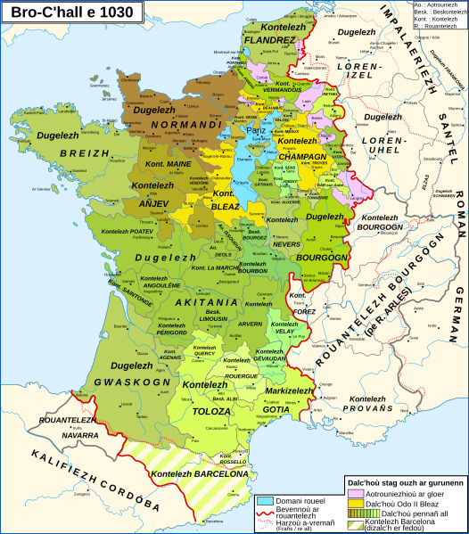
Brezhoneg: Kartenn Rouantelezh Bro-C'hall e 1030
English: Map of the France in 1030
Français : Carte de la France en 1030 |
| Date | |
| Source |
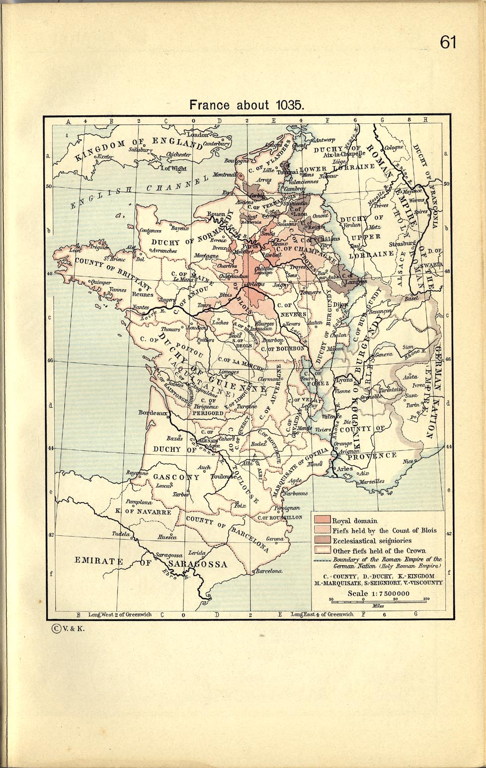
English: From France about 1035, in William R. Shepherd, The Historical Atlas, 1911
Data from the same and:
Français : D'après France about 1035, in William R. Shepherd, The Historical Atlas, 1911
Données d'après cette source et :
|
| Auteur |
|
| Autres versions |
[]
|


Conditions d’utilisation
[modifier]
Ce fichier est disponible selon les termes de la licence Creative Commons Attribution – Partage dans les Mêmes Conditions 3.0 (non transposée).
- Vous êtes libre :
- de partager – de copier, distribuer et transmettre cette œuvre
- d’adapter – de modifier cette œuvre
- Sous les conditions suivantes :
- paternité – Vous devez donner les informations appropriées concernant l'auteur, fournir un lien vers la licence et indiquer si des modifications ont été faites. Vous pouvez faire cela par tout moyen raisonnable, mais en aucune façon suggérant que l’auteur vous soutient ou approuve l’utilisation que vous en faites.
- partage à l’identique – Si vous modifiez, transformez, ou vous basez sur cette œuvre, vous devez distribuer votre contribution sous la même licence ou une licence compatible avec celle de l’original.
Historique du fichier
Cliquer sur une date et heure pour voir le fichier tel qu'il était à ce moment-là.
| Date et heure | Vignette | Dimensions | Utilisateur | Commentaire | |
|---|---|---|---|---|---|
| actuel | 24 février 2024 à 17:18 | | 989 × 1 126 (741 kio) | Adriendelucca (d | contributions) | testenn adaozet / ajustement de texte |
| 4 octobre 2023 à 15:52 |  | 989 × 1 126 (712 kio) | Adriendelucca (d | contributions) | Uploaded a work by *File:Map_France_1030-fr.svg: Zigeuner *troet e brezhoneg gant Adriendelucca from {{en|Own work, from [http://www.lib.utexas.edu/maps/historical/shepherd_1911/shepherd-c-061.jpg France about 1035], in William R. Shepherd, ''The Historical Atlas'', 1911 Data from the same and: *Olivier Guyotjeannin, ''Atlas de l'histoire de France IXe-XVe siècle'', Paris, 2005 *François Menant, H. Martin, B. Merdignac & M. Chauvin, ''Les Capétien... |
Vous ne pouvez pas remplacer ce fichier.
Utilisations locales du fichier
Les 13 pages suivantes utilisent ce fichier :
- User:Adriendelucca
- User:Chumwa/OgreBot/Travel and communication maps/2023 October 1-10
- User:Chumwa/OgreBot/Travel and communication maps/2024 February 20-29
- User:Magog the Ogre/Multilingual legend/2023 October 1-4
- User:Magog the Ogre/Multilingual legend/2024 February 20-24
- File:Map France 1030-br.svg
- File:Map France 1030-ca.svg
- File:Map France 1030-de.svg
- File:Map France 1030-es.svg
- File:Map France 1030-fr.svg
- File:Map France 1030-ru.svg
- File:Map France 1180-ru.svg
- Template:Other versions/France 1030
Utilisations du fichier sur d’autres wikis
Les autres wikis suivants utilisent ce fichier :
- Utilisation sur br.wikipedia.org
Métadonnées
Catégories :
- Breton-language maps
- Breton-language SVG maps
- SVG maps of the history of France
- Maps showing 11th-century history
- Maps of 11th-century France
- Maps showing 1030
- County of Champagne
- Kingdom of Burgundy
- County of Burgundy
- Duchy of Burgundy
- Maps of the county of Flanders
- Duchy of Brittany
- Duchy of Normandy
- Maps of the history of Lorraine
- Maine (province)
- Maps of Poitou
- Bourbonnais
- Nivernais
- Marche (province)
- County of Anjou
- Angoumois
- Saintonge
- County of Auvergne
- Forez
- Maps of Limousin
- Maps of the history of Provence
- Kingdom of Navarre
- Maps of the County of Barcelona
- County of Toulouse
- Roussillon
- Maps of Gascogne