Category:Kingdom of Burgundy
Jump to navigation
Jump to search
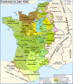
English: Burgundy is a historic region in Western Europe that has existed as a political entity in a number of forms with very different boundaries. Two of these entities - the first around the 6th century, the second around the 11th century - have been called the Kingdom of Burgundy; a third was very nearly created including a county and Duchy, almost all of them being influential and fairly wealthy. In the last stages of the later house of Burgundy, Burgundy had became one of the most influential and powerful states in Europe and a great prize as a duchy, with possessions obtained by marriage and inheritance extending from and encompassing the Netherlands (then including modern Belgium), and extensive lands from Lorraine and encompassing the entire surrounds of the valley of the Rhone River, nearly to the Rhine abutting western Switzerland extending down the Rhone Valley to the Mediterranean coast.
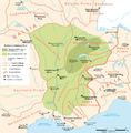
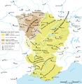
Français : Un premier royaume de Bourgogne, la Burgondie, fut créé par le peuple burgonde après son installation sur les bords du lac Léman, en Sapaudie, au . Son souverain le plus glorieux, Gondebaud, gouverna alors un territoire qui s'étend de Langres à Marseille et du Rhin à la Loire.
history of all the kingdoms and others states named Burgundy .svg)  | |||||
| Upload media | |||||
| Instance of | |||||
|---|---|---|---|---|---|
| Basic form of government | |||||
| Official language | |||||
| Has part(s) |
| ||||
| Different from | |||||
| |||||
Subcategories
This category has the following 2 subcategories, out of 2 total.
P
Media in category "Kingdom of Burgundy"
The following 33 files are in this category, out of 33 total.
-
 Banner of arms of the kingdom of Arles.png 1,775 × 1,775; 25 KB
-
 Burgundies 3.png 479 × 487; 128 KB
-
 Burgundy kings.png 842 × 595; 31 KB
-
 Denier of Conrad the Peaceful.jpg 590 × 589; 145 KB
-
 Denier of Conrad the Peaceful.webp 800 × 381; 94 KB
-
 Karte Koenigreich Burgund 2 DE.png 1,500 × 1,529; 202 KB
-
 Karte Koenigreich Burgund DE.png 1,500 × 1,529; 405 KB
-
 Le royaume Burgonde au Ve siècle-ru.svg 586 × 753; 119 KB
-
 Le royaume des Francs sous Hugues Capet-be.svg 1,796 × 1,796; 1.36 MB
-
 Le royaume des Francs sous Hugues Capet-en.svg 1,796 × 1,796; 1.37 MB
-
 Le royaume des Francs sous Hugues Capet-es.svg 1,916 × 1,916; 1.37 MB
-
 Le royaume des Francs sous Hugues Capet-fr.svg 1,796 × 1,796; 1.38 MB
-
 Le royaume des Francs sous Hugues Capet-ka.svg 1,796 × 1,800; 1.23 MB
-
 Le royaume des Francs sous Hugues Capet-ru.svg 1,796 × 1,796; 1.07 MB
-
 Les pagi de la Bourgogne Viennoise au VIIIe et IXe siècle.gif 972 × 972; 210 KB
-
 Map Burgundia 443-476-hu.svg 1,068 × 1,081; 366 KB
-
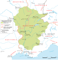
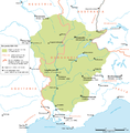 Map Burgundian Kingdom 2 EN.png 1,500 × 1,529; 204 KB
-
 Map Burgundian Kingdom 2 hu.svg 2,000 × 2,039; 370 KB
-
 Map Burgundian Kingdom EN.png 1,500 × 1,529; 242 KB
-
 Map Burgundian Kingdom-el.png 1,500 × 1,529; 317 KB
-
 Map Burgundian Kingdom-es.svg 1,002 × 1,014; 245 KB
-
 Map Burgundian Kingdom-hu.svg 1,002 × 1,014; 237 KB
-
 Map Burgundian Kingdom.svg 1,002 × 1,014; 236 KB
-
 Map Burgundian Kingdom443-476-es.svg 1,068 × 1,081; 1.14 MB
-
 Map Burgundian Kingdom443-476-ru.svg 1,067 × 1,082; 361 KB
-
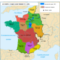
 Map France 1030-br.svg 989 × 1,126; 741 KB
-
 Map France 1030-de.svg 988 × 1,124; 1.49 MB
-
 Map France 1030-es.svg 1,053 × 1,199; 4.12 MB
-
 Map France 1030-fr.svg 989 × 1,126; 718 KB
-
 Map France 1030-ru.svg 988 × 1,124; 789 KB
-
 Map France 1030-uk.svg 988 × 1,124; 789 KB
-
 Map Kingdom Arelat AR.png 1,454 × 1,485; 856 KB
-
 Map Kingdom Arelat EN.png 1,310 × 1,338; 209 KB


