File:Map Iberian Peninsula 1037-es.svg
跳至導覽
跳至搜尋

此 SVG 檔案的 PNG 預覽的大小:800 × 555 像素。 其他解析度:320 × 222 像素 | 640 × 444 像素 | 1,024 × 711 像素 | 1,280 × 888 像素 | 2,560 × 1,777 像素 | 827 × 574 像素。
原始檔案 (SVG 檔案,表面大小:827 × 574 像素,檔案大小:252 KB)
說明
說明
添加單行說明來描述出檔案所代表的內容
摘要
[編輯]| 描述 |
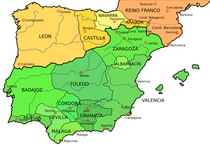
English: Map of the Iberian Peninsula in 1037
Español: Mapa de la Península ibérica en 1037 |
| 日期 | |
| 來源 | File:España1037.jpg, that comes from [1] liberated to the public domain by the University of Texas at Austin. |
| 作者 | Crates |
| 其他版本 |
[]
See also[編輯]
Derivative works of this file: Map Iberian Peninsula 1037-en.svg File:España1037.jpg (JPG version) |


![[1]](http://www.lib.utexas.edu/maps/historical/shepherd_1911/shepherd-c-082-083.jpg)

|
This SVG file contains embedded text that can be translated into your language, using any capable SVG editor, text editor or the SVG Translate tool. For more information see: About translating SVG files. |
授權條款
[編輯]
我,本作品的著作權持有者,決定用以下授權條款發佈本作品:

|
已授權您依據自由軟體基金會發行的無固定段落、封面文字和封底文字GNU自由文件授權條款1.2版或任意後續版本,對本檔進行複製、傳播和/或修改。該協議的副本列在GNU自由文件授權條款中。 |
This file is licensed under the Creative Commons Attribution-Share Alike Attribution-Share Alike 4.0 International, 3.0 Unported, 2.5 Generic, 2.0 Generic and 1.0 Generic license.
- 您可以自由:
- 分享 – 複製、發佈和傳播本作品
- 重新修改 – 創作演繹作品
- 惟需遵照下列條件:
- 姓名標示 – 您必須指名出正確的製作者,和提供授權條款的連結,以及表示是否有對內容上做出變更。您可以用任何合理的方式來行動,但不得以任何方式表明授權條款是對您許可或是由您所使用。
- 相同方式分享 – 如果您利用本素材進行再混合、轉換或創作,您必須基於如同原先的相同或兼容的條款,來分布您的貢獻成品。
您可以選擇您需要的授權條款。
檔案歷史
點選日期/時間以檢視該時間的檔案版本。
| 日期/時間 | 縮圖 | 尺寸 | 用戶 | 備註 | |
|---|---|---|---|---|---|
| 目前 | 2009年1月18日 (日) 00:11 | | 827 × 574(252 KB) | Phirosiberia(對話 | 貢獻) | {{Information |Description={{en|1=Map of the Iberian Peninsula in 1037}} {{es|1=Mapa de la Península ibérica en 1037}} |Source=File:España1037.jpg, that comes from [http://www.lib.utexas.edu/maps/historical/shepherd_1911/shepherd-c-082-083.jpg] li |
無法覆蓋此檔案。
檔案用途
下列12個頁面有用到此檔案:
- Maps of Spain
- Reconquista
- File:España1037.jpg
- File:Map Iberian Peninsula 1037-bg.svg
- File:Map Iberian Peninsula 1037-en.svg
- File:Map Iberian Peninsula 1037-es.svg
- File:Map Iberian Peninsula 1037-hu.svg
- File:Map Iberian Peninsula 1037-pt.svg
- File:Península ibérica 1037.svg (檔案重新導向)
- Template:Other versions/Map Iberian Peninsula 1037
全域檔案使用狀況
以下其他 wiki 使用了這個檔案:
- af.wikipedia.org 的使用狀況
- arz.wikipedia.org 的使用狀況
- ast.wikipedia.org 的使用狀況
- azb.wikipedia.org 的使用狀況
- br.wikipedia.org 的使用狀況
- ca.wikipedia.org 的使用狀況
- de.wikipedia.org 的使用狀況
- el.wikipedia.org 的使用狀況
- en.wikipedia.org 的使用狀況
- es.wikipedia.org 的使用狀況
- eu.wikipedia.org 的使用狀況
- fr.wikipedia.org 的使用狀況
- gl.wikipedia.org 的使用狀況
- hy.wikipedia.org 的使用狀況
- id.wikipedia.org 的使用狀況
- it.wikipedia.org 的使用狀況
- ko.wikipedia.org 的使用狀況
- lt.wikipedia.org 的使用狀況
- nl.wikipedia.org 的使用狀況
- no.wikipedia.org 的使用狀況
- pt.wikipedia.org 的使用狀況
- th.wikipedia.org 的使用狀況
- uk.wikipedia.org 的使用狀況
- zh.wikipedia.org 的使用狀況
分類:
- Maps showing 1037
- History of Catalonia
- Iberian kingdoms
- Maps of 11th-century Iberian Peninsula
- Maps of the Frankish territory
- Maps of the Kingdom of Aragon
- Maps of the Kingdom of León
- Maps showing 11th-century history
- Spanish-language SVG maps showing history of Europe
- Maps of the taifa kingdoms
- Maps of the County of Barcelona
- 1037 in Spain