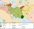
File:Map Iran 1900-en.png

Faylın orijinalı (1.096 × 911 piksel, fayl həcmi: 352 KB, MIME növü: image/png)
Captions
Captions

|
This historical map image could be re-created using vector graphics as an SVG file. This has several advantages; see Commons:Media for cleanup for more information. If an SVG form of this image is available, please upload it and afterwards replace this template with
{{vector version available|new image name}}.
It is recommended to name the SVG file “Map Iran 1900-en.svg”—then the template Vector version available (or Vva) does not need the new image name parameter. |
Xülasə[redaktə]
| İzahMap Iran 1900-en.png |
Lisenziya[redaktə]I, the copyright holder of this work, hereby publish it under the following license: This file is licensed under the Creative Commons Attribution-Share Alike 2.5 Generic, 2.0 Generic and 1.0 Generic license.
|
||||||||
|
Note : |
|||||||||
See also the French version: Image:Map_Iran_1900-fr.png
Faylın tarixçəsi
Faylın əvvəlki versiyasını görmək üçün gün/tarix bölməsindəki tarixlərə klikləyin.
| Tarix/Vaxt | Kiçik şəkil | Ölçülər | İstifadəçi | Şərh | |
|---|---|---|---|---|---|
| indiki | 17:40, 6 avqust 2017 |  | 1.096 × 911 (352 KB) | Oganesson007 (müzakirə | töhfələr) | Added Kingdom of Kartli-Kakheti, deleted modern day Turkmenistan, which was never under Qajar's control. |
| 15:18, 20 iyul 2015 |  | 1.096 × 911 (353 KB) | LouisAragon (müzakirə | töhfələr) | When people say your previous map that showed the same is wrong, don't sneakily change it on an already existing map to push your PoV. Cais-Soas is not a source. | |
| 19:46, 19 iyul 2015 |  | 1.096 × 910 (327 KB) | History of Persia (müzakirə | töhfələr) | The Qajars had control of Herat before 1857.EVIDENCE: Treaty of Paris (1857) (wikipedia article). See the reference list for that article. Also see this map of Persia from 1808: http://www.cais-soas.com/CAIS/Images2/Maps/breaku1.jpg | |
| 19:42, 19 iyul 2015 |  | 1.096 × 910 (327 KB) | History of Persia (müzakirə | töhfələr) | The Qajars had control of Herat before 1857. EVIDENCE: Treaty of Paris (1857) (wikipedia article). Also see the reference list for that article. Also see this map of Persia from 1808: https://upload.wikimedia.org/wikipedia/commons/thumb/f/f9/Persia1808... | |
| 17:29, 24 iyun 2013 |  | 1.096 × 911 (353 KB) | HistoryofIran (müzakirə | töhfələr) | Fixed the horrible non-accurate borders and fixed territorial losses. | |
| 15:53, 28 aprel 2013 |  | 1.096 × 911 (356 KB) | HistoryofIran (müzakirə | töhfələr) | ||
| 21:35, 24 sentyabr 2006 |  | 1.096 × 911 (358 KB) | Fabienkhan (müzakirə | töhfələr) | uploaded updated version | |
| 21:32, 24 sentyabr 2006 |  | 1.098 × 927 (367 KB) | Fabienkhan (müzakirə | töhfələr) | ||
| 20:58, 24 sentyabr 2006 |  | 1.098 × 924 (384 KB) | Fabienkhan (müzakirə | töhfələr) | <div style="height:8px; border:1px solid #8898BF; -moz-border-radius-topleft:8px; -moz-border-radius-topright:8px; background:#C8D8FF; font-size:1px;"> </div> <div style="margin-bottom:1.5em; border:1px solid #8898BF; border-top:0; padding:5px; background |
Siz bu faylı yenidən yükləyə bilməzsiniz.
Fayl keçidləri
Aşağıdakı 6 səhifə bu faylı istifadə edir:
Faylın qlobal istifadəsi
Bu fayl aşağıdakı vikilərdə istifadə olunur:
- ar.wikipedia.org layihəsində istifadəsi
- ast.wikipedia.org layihəsində istifadəsi
- azb.wikipedia.org layihəsində istifadəsi
- az.wikipedia.org layihəsində istifadəsi
- ba.wikipedia.org layihəsində istifadəsi
- be.wikipedia.org layihəsində istifadəsi
- bg.wikipedia.org layihəsində istifadəsi
- bo.wikipedia.org layihəsində istifadəsi
- ca.wikipedia.org layihəsində istifadəsi
- ckb.wikipedia.org layihəsində istifadəsi
- cs.wikipedia.org layihəsində istifadəsi
- de.wikipedia.org layihəsində istifadəsi
- el.wikipedia.org layihəsində istifadəsi
- en.wikipedia.org layihəsində istifadəsi
- Iran
- History of Iran
- Great Game
- Sphere of influence
- Anglo-Russian Convention
- Military history of Iran
- Territorial evolution of Russia
- History of Azerbaijan
- Iranian nationalism
- Portal:Azerbaijan
- Russia–United Kingdom relations
- Wikipedia:Graphics Lab/Images to improve/Archive/Apr 2008
- Qajar Iran
- User:Chickstarr404/Gather lists/14627 – Personal History - Desert Gardens by Vincent Sheehan
- User:Joelton Ivson/Gather lists/24351 – Geórgia
- User:Joelton Ivson/Gather lists/24359 – Os Persas
- User:Falcaorib
- User:Thecatcherintherye/Sandbox
- Turkoman (ethnonym)
- Erdoğan Iran poem controversy
- User talk:A Contemporary Nomad
- es.wikipedia.org layihəsində istifadəsi
Bu faylın qlobal istifadəsinə baxın.
