File:Map Kingdom Arelat AR.png
Siirry navigaatioon
Siirry hakuun

Tämän esikatselun koko: 587 × 600 kuvapistettä. Muut resoluutiot: 235 × 240 kuvapistettä | 470 × 480 kuvapistettä | 752 × 768 kuvapistettä | 1 003 × 1 024 kuvapistettä | 1 454 × 1 485 kuvapistettä.
Alkuperäinen tiedosto (1 454 × 1 485 kuvapistettä, 856 KiB, MIME-tyyppi: image/png)
Kuvatekstit
Kuvatekstit
Lisää yhden rivin pituinen kuvaus tästä tiedostosta
Yhteenveto
[muokkaa]| Kuvaus |
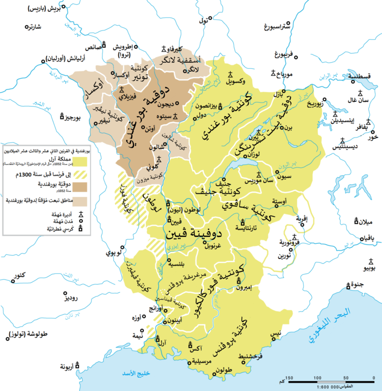
العربية: مملكة آرل ودوقيَّة بورغندية القبطانيَّة في القرنين الثاني عشر والثالث عشر الميلاديين. |
| Päiväys | |
| Lähde |
Tämä tiedosto on johdettu tiedostosta: Map Kingdom Arelat EN.png |
| Tekijä | |
| Muut versiot |
|


| Tämän kuvan originaalia on jälkikäsitelty digitaalisesti. Muutokset: Translated to Arabic - عُرِبَت. Originaali: Map Kingdom Arelat EN.png. Muokkaaja: باسم.
|
Lisenssi
[muokkaa]
You may use my work outside wikipedia for free as long as you name me as the author. If you would like to use my work in a print medium, please send me a specimen copy.
Contact me if you have questions regarding the license or if you want individual changes to the map (marco.zanoli at hotmail.ch). Tämä tiedosto on lisensoitu Creative Commons Nimeä-JaaSamoin 4.0 Kansainvälinen -lisenssillä. Nimeä: Marco Zanoli
|
Tiedoston historia
Päiväystä napsauttamalla näet, millainen tiedosto oli kyseisellä hetkellä.
| Päiväys | Pienoiskuva | Koko | Käyttäjä | Kommentti | |
|---|---|---|---|---|---|
| nykyinen | 30. syyskuuta 2017 kello 19.40 | | 1 454 × 1 485 (856 KiB) | باسم (keskustelu | muokkaukset) | User created page with UploadWizard |
Et voi tallentaa uutta tiedostoa tämän tilalle.
Tiedoston käyttö
Seuraava sivu käyttää tätä tiedostoa:
Tiedoston järjestelmänlaajuinen käyttö
Seuraavat muut wikit käyttävät tätä tiedostoa:
- Käyttö kohteessa ar.wikipedia.org
Metatieto
Luokat:
- Maps of the history of Burgundy
- History of Bourgogne
- Maps of the kingdom of France
- Maps of the history of Switzerland
- Duchy of Burgundy
- County of Burgundy
- Nivernais
- Maps of Lyonnais
- Forez
- Maps of Dauphiné
- Maps of the Duchy of Savoy
- Maps of the history of Provence
- Maps of 11th-century Europe
- Maps of 12th-century Europe
- Kingdom of Arles
- Kingdom of Burgundy