File:Map The Acropolis of Athens and its slopes 1928-1940 - Touring Club Italiano CART-TRC-37.jpg
跳转到导航
跳转到搜索

本预览的尺寸:800 × 580像素。 其他分辨率:320 × 232像素 | 640 × 464像素 | 1,024 × 743像素 | 1,280 × 929像素 | 2,560 × 1,857像素 | 8,279 × 6,007像素。
原始文件 (8,279 × 6,007像素,文件大小:31.78 MB,MIME类型:image/jpeg)
说明
说明
添加一行文字以描述该文件所表现的内容
摘要
[编辑]| 标题 |
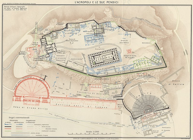
The Acropolis of Athens and its slopes |
|
| 描写 |
English: The map shows the Acropolis of Athens and its slopes, giving additional information about the state of conservation of the buildings and their different architectural styles. It derives from Judeich's"Topographie von Athen" and it was updated by Professor Della Seta. The map is one of the tables made by the TCI Cartographic Office for the Italian Encyclopedia of Giovanni Treccani Institute Italiano: La mappa mostra l'Acropoli di Atene e le sue pendici, dando informazioni riguardo lo stato di conservazione dei diversi monumenti che compongono il complesso archeologico e il diverso stile architettonico che li contraddistingue, correlato al periodo in cui vennero costruiti. Derivata dalla "Topographie von Athen" di Judeich, con aggiornamenti a cura del Professor Della Seta. La mappa è una delle tavole realizzate dall'Ufficio Cartografico del TCI per l'Enciclopedia Italiana Giovanni Treccani |
|
| 日期 | 在1928年到1940年之间 | |
| 来源 | 扫描自原作品 Archivio Storico del Touring Club Italiano | |
| 授权 (二次使用本文件) |
|
|
| Geotemporal data | ||
| 地图位置 | Greece | |
| 地图类型 | Maps of archeological sites | |
| 比例尺 | 1: 1 300 | |
| 地理参考 | 如果不适当,请设置 warp_status = skip 为隐藏。 | |
| Bibliographic data | ||
| 系列 | 1° Edition Italian Encyclopedia Giovanni Treccani | |
| 语言 | 意大利语 | |
| 出版地 | Milan | |
| 出版者 |
TCI |
|
| 印刷自 |
Vallardi |
|
| Archival data | ||
| 馆藏 | ||
| 登录号 |
CART.TRC.37 |
|

许可协议
[编辑]
文件历史
点击某个日期/时间查看对应时刻的文件。
| 日期/时间 | 缩略图 | 大小 | 用户 | 备注 | |
|---|---|---|---|---|---|
| 当前 | 2022年10月18日 (二) 07:13 | | 8,279 × 6,007(31.78 MB) | Marta Arosio (WMIT)(留言 | 贡献) | Cropped 8 % horizontally, 16 % vertically using CropTool with lossless mode. |
| 2022年10月13日 (四) 12:58 |  | 9,048 × 7,153(18.31 MB) | Ilaria Parma (TCI)(留言 | 贡献) | pattypan 22.03 |
您不可以覆盖此文件。
文件用途
全域文件用途
以下其他wiki使用此文件:
- az.wikipedia.org上的用途
- en.wikipedia.org上的用途
- fr.wikipedia.org上的用途
- it.wikipedia.org上的用途
- mk.wikipedia.org上的用途
- outreach.wikimedia.org上的用途
- ru.wikipedia.org上的用途
- zh.wikipedia.org上的用途
元数据
分类:
- Maps of ancient Greece
- Maps of Athens
- Maps by TCI Cartographic Office
- Enciclopedia Treccani - Maps
- Italian-language maps
- Plans of the Acropolis of Athens
- 1930s maps showing history
- Touring Club Italiano maps showing history
- Augustus
- Italian-language maps showing history of Italy
- 1930s maps from Archivio Storico Touring Club Italiano